

Wet At Times This Weekend; Drier Monday
RADAR CHECK: Again today we have scattered to numerous showers and storms across the great state of Alabama…. moving eastward producing heavy rain and frequent lightning.
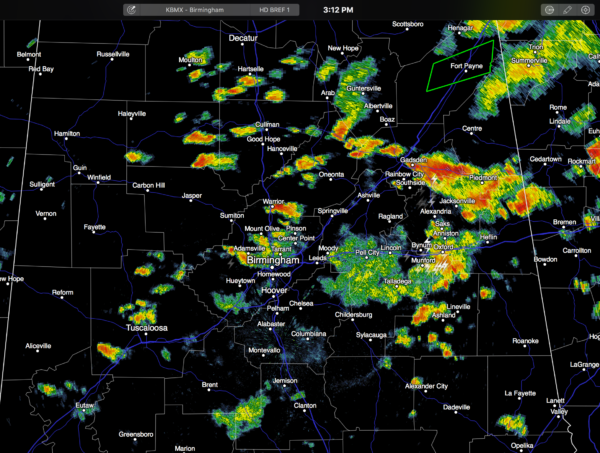
A flash flood warning is in effect for parts of DeKalb County, including Fort Payne… it will expire at 4:45p CT.
Showers and storms will slowly fade late tonight, but some high school football stadiums could get wet on week one of the season. I would take the rain gear for that reason.
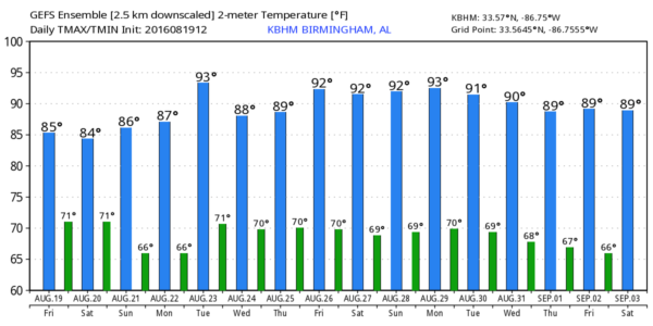
TOMORROW/SUNDAY: Not much change over the weekend… a very moist, unstable airmass will remain parked over Alabama with a number of showers and storms around both days. Best chance of rain will come during the afternoon and evening hours, but we can’t rule out a late night or morning shower. With just a limited amount of sunshine, we project a high in the mid to upper 80s both days.
A surface front will creep into far North Alabama later in the weekend, and places like Florence, Athens, and Huntsville could get into drier air Sunday, but the rest of the state will stay rather unsettled.
NEXT WEEK: Drier, continental air slips into the northern half of the state, and we expect shower-free weather Monday and Tuesday (for North and Central Alabama) with lower humidity and cooler nights. Some of the normally cooler spots could visit the upper 50s early Tuesday for a nice preview of fall. But, moisture returns Wednesday with a risk of scattered showers and storms for the latter half of the week. See the Weather Xtreme video for maps, graphics, and more details.
AT THE BEACH: About 7 to 9 hours of sunshine through early next week on the coast from Panama City Beach to Gulf Shores with a few scattered showers and storms around daily. Highs 87-90 on the immediate coast, with low 90s inland. See a very detailed Gulf Coast forecast here.
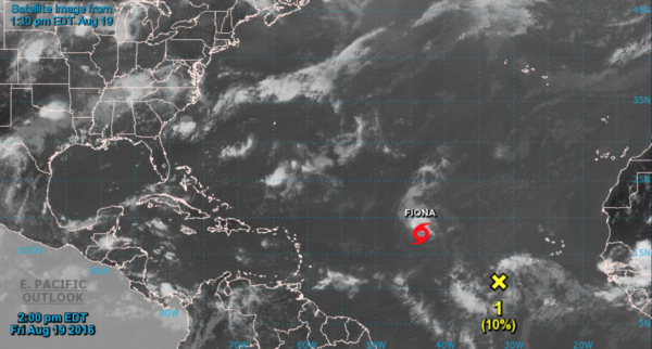
FIONA: The tropical storm in the open Atlantic is fighting dry air, and should weaken to a tropical depression over the weekend. It will turn northward and is no threat to land, if it survives.
INVEST 99: The system southeast of Fiona will take a more low latitude track, and has a chance of becoming Tropical Storm Gaston in coming days. Global models are not in very good agreement; remains to be seen if this will impact the U.S. See the Weather Xtreme video for much more information and all the graphics.
WEATHER BRAINS: Don’t forget you can listen to our weekly 90 minute netcast anytime on the web, or on iTunes. This is the show all about weather featuring many familiar voices, including our meteorologists here at ABC 33/40.
CONNECT: You can find me on all of the major social networks…
Facebook
Twitter
Google Plus
Instagram
Look for my next Weather Xtreme video early Monday morning by 7:00… Brian Peters will have the video updates tomorrow and Sunday. Enjoy the weekend!
Category: Alabama's Weather
About the Author (Author Profile)
James Spann is one of the most recognized and trusted television meteorologists in the industry. He holds the AMS CCM designation and television seals from the AMS and NWA. He is a past winner of the Broadcast Meteorologist of the Year from both professional organizations.Subscribe
If you enjoyed this article, subscribe to receive more just like it.


