

Pleasant Mornings, Hot Afternoons
NEW DAY, OLD FORECAST: Today will be the seventh consecutive day with no rain for Birmingham and most of North/Central Alabama; dry air means a mostly sunny sky with a high up in the low to mid 90s this afternoon. On the positive side, dew points remain low, and the humidity values during the peak of the heat later today will be only in the 20/30 percent range.
And, no change tomorrow. Lots of sun, a high between 92 and 95, and fairly low humidity levels.
THE ALABAMA WEEKEND: We will keep an eye on a weak surface front that will drift down into North Alabama Saturday night, but the day Saturday looks rain-free with a partly sunny sky and a high in the low 90s. We will mention a small risk of a shower with the front Saturday night and Sunday, but with little moisture and no real upper support, the chance of any one spot getting wet is only about one in ten. The high Sunday will drop back into the upper 80s with the sky remaining partly sunny.
FOOTBALL WEATHER: High school games played under tomorrow night lights across Alabama will be rain-free with a clear sky; temperatures will fall from the mid 80s at kickoff into the 70s by the final whistle.
Alabama hosts Western Kentucky Saturday at Bryant-Denny Stadium for the 2016 home opener (2:30p CT kickofF)… the sky will be mostly sunny with 92 degrees at kickoff… dropping back into the upper 80s by the end of the game. You won’t be needing a jacket or sweater… we promise.
Auburn will host Arkansas State at Jordan Hare Stadium Saturday evening (6:30p CT kickoff)… the sky will be mostly fair with temperatures falling from 86 degrees at kickoff into the upper 70s by the fourth quarter.
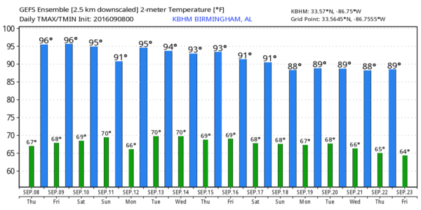
NEXT WEEK: The generally dry pattern continues. We might consider a small risk of a shower Monday over Central and South Alabama south of the stalled surface front, but again the chance of any one front yard getting rain is very small. The latest model data suggests highs around 90, and lows between 67 and 70. See the Weather Xtreme video for maps, graphics, and more details.
AT THE BEACH: Mostly sunny days, fair nights, and only isolated storms on the coast from Gulf Shores to Panama City Beach through the weekend. Highs in the upper 80s on the immediate coast, with low 90s inland. See a very detailed Gulf Coast forecast here.
TROPICS: A tropical wave in the eastern Atlantic near the Cape Verde Islands could show some development in coming days, but odds are high this gains latitude and won’t impact the Caribbean or the Gulf. NHC has actually lowered the development odds a bit overnight.
ON THIS DATE IN 1900: An estimated Category 4 storm made landfill in Galveston, Texas. This hurricane killed between 6,000 and 12,000 individuals, making it the deadliest U.S. Atlantic hurricane on record. The highest point in the city of Galveston was less than nine feet above sea level. The hurricane brought a storm surge of over 15 feet, which overwhelmed the entire island.
WEATHER BRAINS: Don’t forget you can listen to our weekly 90 minute netcast anytime on the web, or on iTunes. This is the show all about weather featuring many familiar voices, including our meteorologists here at ABC 33/40.
CONNECT: You can find me on all of the major social networks…
Facebook
Twitter
Google Plus
Instagram
I have a weather program this morning at Clanton Middle School… be looking for the next Weather Xtreme video here by 4:00 this afternoon… enjoy the day!
Category: Alabama's Weather
About the Author (Author Profile)
James Spann is one of the most recognized and trusted television meteorologists in the industry. He holds the AMS CCM designation and television seals from the AMS and NWA. He is a past winner of the Broadcast Meteorologist of the Year from both professional organizations.Subscribe
If you enjoyed this article, subscribe to receive more just like it.


