Weak Front Arrives Over The Weekend
ANOTHER DRY DAY: This is the seventh consecutive day with no measurable rain for much of North/Central Alabama… temperatures are mostly in the low 90s with a good supply of sunshine. Birmingham reported 91 degrees at 2:00 with a dew point of 59, making the relative humidity 33 percent. The humidity at the Shelby County Airport dropped to 28 percent.
The weather won’t change much tomorrow; dry air stays in place. The sky will be mostly sunny with a high between 91 and 94 degrees.
THE WEEKEND: A weak surface front will drift down into North Alabama Saturday night. The day Saturday still looks dry with a high in the low 90s, but the high resolution NAM model suggests a broken band of showers will drift into North Alabama Saturday evening…
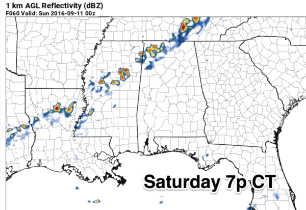
These showers will become fewer in number as they move southeast, but we will mention a small risk of a shower Saturday night and Sunday. Nothing widespread or beneficial, but a few lawns might see a little rain. Sunday will feature a partly sunny sky with a high in the upper 80s.
FOOTBALL WEATHER: High school games played under tomorrow night lights across Alabama will be rain-free with a clear sky; temperatures will fall from the mid 80s at kickoff into the 70s by the final whistle.
Alabama hosts Western Kentucky Saturday at Bryant-Denny Stadium for the 2016 home opener (2:30p CT kickofF)… the sky will be partly sunny with 92 degrees at kickoff… dropping back into the upper 80s by the end of the game. You won’t be needing a jacket or sweater… we promise. Keep in mind a few isolated showers are possible in Tuscaloosa after the game Saturday night.
Auburn will host Arkansas State at Jordan Hare Stadium Saturday evening (6:30p CT kickoff)… the sky will be mostly fair with temperatures falling from 86 degrees at kickoff into the upper 70s by the fourth quarter.
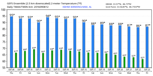
NEXT WEEK: The front over Alabama will wash out early in the week, and the pattern still looks mostly dry. Any showers Monday will be widely spaced, and the risk of a shower is so small Tuesday through Thursday that we won’t mention it in the forecast. Highs next week will be in the 88-92 degree range; lows will be in the 60s. See the Weather Xtreme video for maps, graphics, and more details.
AT THE BEACH: Mostly sunny days, fair nights, and only widely scattered storms on the coast from Panama City Beach to Gulf Shores through the weekend. Highs on the immediate coast in the upper 80s, with low 90s inland. See a very detailed Gulf Coast forecast here.
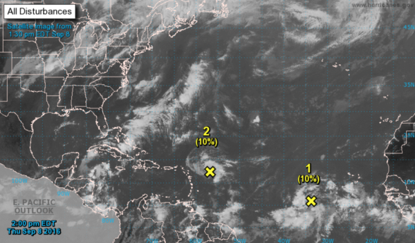
TROPICS: NHC is monitoring two tropical waves; both are disorganized. One is east of the Leeward Islands (designated Invest 93L), and the other is farther out in the eastern Atlantic. Higher probability of development goes to the eastern-most system; remains to be seen if they develop at all, or impact any landmass.
WEATHER BRAINS: Don’t forget you can listen to our weekly 90 minute netcast anytime on the web, or on iTunes. This is the show all about weather featuring many familiar voices, including our meteorologists here at ABC 33/40.
CONNECT: You can find me on all of the major social networks…
Facebook
Twitter
Google Plus
Instagram
I had a great time today visiting the 6th graders at Clanton Middle School… be looking for them on the Pepsi KIDCAM today at 5:00 on ABC 33/40 News at 5:00! The next Weather Xtreme video will be posted here by 7:00 a.m. tomorrow…
Category: Alabama's Weather
About the Author (Author Profile)
James Spann is one of the most recognized and trusted television meteorologists in the industry. He holds the AMS CCM designation and television seals from the AMS and NWA. He is a past winner of the Broadcast Meteorologist of the Year from both professional organizations.Subscribe
If you enjoyed this article, subscribe to receive more just like it.


