

Coolest Air So Far This Fall Arrives Tonight
LONG DRY SPELL: Today is the 10th consecutive day with no rain for Birmingham (and most of North/Central Alabama), and unfortunately we see no real signifiant chance of rain around here for the next seven to ten days. And, remember October is typically the driest month of the year here. Lake Purdy is very low (photo below from Edward Burch of ABC 33/40), and the Birmingham Water Works announced a stage-one drought advisory yesterday… asking customers to “use water wisely and limit unnecessary usage.”

COOLEST AIR SO FAR THIS SEASON: It arrives tonight. Tomorrow and Friday will be delightful with sunny pleasant days and clear cool nights. Highs drop into the mid 70s, with lows well down in the 50s. Cooler spots, like this morning, will hit the mid to upper 40s.
THE WEEKEND: Not much change. Lots of sunshine both days; the high Saturday will be in the upper 70s, followed by low 80s Sunday. Lows hold in the 50s.
FOOTBALL WEATHER: Looking fantastic for Friday night’s high school games; a clear sky with temperatures falling through the 60s during the games (remember, they were falling through the 80s this past Friday night). Some stadiums will see 50s by the fourth quarter, and a light jacket will be in order.
Alabama will host Kentucky Saturday evening at Bryant-Denny Stadium (6:00p CT kickoff)… the sky will be clear with temperatures falling from 73 at kickoff, into the mid 60s by the fourth quarter.
Auburn hosts Louisiana-Monroe Saturday at Jordan Hare Stadium (2:30p CT kickoff)… expect a sunny sky with a kickoff temperature of 76 degrees…falling into the upper 60s by the final whistle.
NEXT WEEK: Still dry with mostly sunny days; highs will be in the 80s and lows in the upper 50s and low 60s. See the Weather Xtreme video for maps, graphics, and more details.
AT THE BEACH: Mostly sunny days, fair nights on the coast from Panama City Beach to Gulf Shores with only isolated storms; highs will be in the 80s. See a very detailed Gulf Coast forecast here.
NEW TROPICAL STORM: A good chance Matthew, now in the vicinity of the Windward Islands, becomes a hurricane within the next 48 hours as it moves through the Caribbean. Just about all model guidance still suggests a sharp turn to the north this weekend, and the official NHC track does the same.
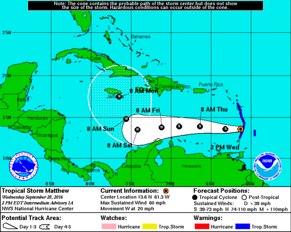
The chance of Matthew getting into the Gulf of Mexico is not zero, but very low based on the projected upper air pattern, and looking at analogs. One interesting analog is Hurricane Hazel from 1954, which also made that sharp right turn in the Caribbean. It would go to make landfall in the Carolinas, but it remains to be seen if Matthew impacts the U.S. East Coast. But, everyone from Key West to Cape Cod will need to monitor the system closely over the next 5 to 10 days. See the Weather Xtreme video for more graphics and details.
WEATHER BRAINS: Don’t forget you can listen to our weekly 90 minute netcast anytime on the web, or on iTunes. This is the show all about weather featuring many familiar voices, including our meteorologists here at ABC 33/40.
CONNECT: You can find me on all of the major social networks…
Facebook
Twitter
Google Plus
Instagram
Look for the next Weather Xtreme video here by 7:00 a.m. tomorrow….
Category: Alabama's Weather
About the Author (Author Profile)
James Spann is one of the most recognized and trusted television meteorologists in the industry. He holds the AMS CCM designation and television seals from the AMS and NWA. He is a past winner of the Broadcast Meteorologist of the Year from both professional organizations.Subscribe
If you enjoyed this article, subscribe to receive more just like it.


