

Complex Weekend Storm System
QUIET AFTERNOON: We have a mix of sun and clouds across Alabama this afternoon with temperatures the low 70s; nothing showing up on radar. But, things get active over the weekend as a deep upper low forms west of the state, and unstable air moves northward.
Here is the latest thinking after viewing the new computer model data that arrived this morning…
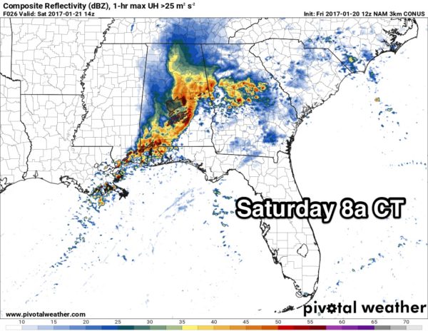
ROUND ONE: The first opportunity for strong to severe storms will come early tomorrow morning, generally in the 3:00 a.m. to 10:00 a.m. time frame. High resolution model data suggests the best combination of instability, shear, and stronger wind fields will be over Central and South Alabama, generally south of I-20 (Tuscaloosa, Birmingham, Anniston and points south).
Storms early tomorrow morning over Central and South Alabama will be capable of producing large hail, damaging winds, and a few tornadoes. For now severe weather over North Alabama, north of I-20, looks unlikely early tomorrow morning.
TOMORROW AFTERNOON/EVENING: The main low level jet, about 5,000 feet off the ground, moves east of Alabama by the afternoon, and it sure looks like this could be a pretty quiet period with some sun breaking through the clouds along with temperatures approaching 70 degrees. But, the air will be rather unstable, and an isolated storm can’t be totally ruled out. But, generally speaking, we should be in a lull tomorrow afternoon and early tomorrow night with few, if any storms.
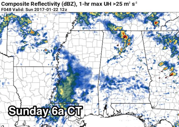
ROUND TWO: The next thunderstorm event comes Sunday with the upper low approaching. Storms could form as early as 2:00 a.m. Sunday, and the chance of storms will continue through the day, although by Sunday afternoon the stronger storms will shift down into areas south and east of Birmingham. Forecast wind fields are rather unidirectional, so for this round of storms it looks like the main threat will come from small hail and gusty thunderstorm winds… the tornado risk looks pretty low for now.
Rain amounts over the weekend should be in the 1-2 inch range, and flash flooding is not expected.
BOTTOM LINE: This is a pretty complex pattern, and understand there could be forecast changes as we get into the weekend, so keep up with the latest posts here on the blog. For now, the primary tornado threat seems to be early tomorrow morning over Central and South Alabama.
CALL TO ACTION: Be sure you have a way of hearing severe weather watches and warnings. At home, you need a properly programmed NOAA Weather Radio with a battery backup. On your phone, for warnings we recommend WeatherRadio by WDT. You can watch our live severe weather coverage on the free ABC 33/40 app. Here are the links…
ABC 33/40 iOS version for iPhones and iPads
ABC 33/40 Android version for Android phones and tablets
Review your action plan in case a tornado warning polygon includes your home. Get in a small room, on the lowest floor, away from windows, and near the center of the house. You do NOT have to be underground. Never be in a car or mobile home.
NEXT WEEK: Monday will be cloudy, windy, and much cooler with a chance of some light rain, mainly during the morning. The high will be in the low to mid 50s. Even colder air returns later in the week with highs dropping into the 40s. See the Weather Xtreme video for maps, graphics, and more details.
As always, watch me for the full weather story on ABC 33/40 News this evening at 4, 5, 6, and 10:00!
WEATHER BRAINS: Don’t forget you can listen to our weekly 90 minute netcast anytime on the web, or on iTunes. This is the show all about weather featuring many familiar voices, including our meteorologists here at ABC 33/40.
CONNECT: You can find me on all of the major social networks…
Facebook
Twitter
Google Plus
Instagram
Snapchat: spannwx
I had a great time today visiting with the 3rd graders at Hillview Elementary in Forestdale… be looking for them on the Pepsi KIDCAM today at 5:00 on ABC 33/40 News! My next Weather Xtreme video will be posted here early Monday morning… Brian Peters will have the video updates tomorrow and Sunday. Enjoy the weekend, and check the blog often for updates…
Category: Alabama's Weather
About the Author (Author Profile)
James Spann is one of the most recognized and trusted television meteorologists in the industry. He holds the AMS CCM designation and television seals from the AMS and NWA. He is a past winner of the Broadcast Meteorologist of the Year from both professional organizations.Subscribe
If you enjoyed this article, subscribe to receive more just like it.


