

Spring-Like Today; Rain Returns Tomorrow
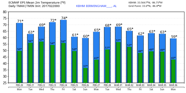
WARM FEBRUARY DAY: The average high today for Birmingham is 60 degrees… we should climb about 15 degrees above that today with a high in the mid to upper 70s along with a good supply of sunshine. If you enjoyed the weather yesterday, you will love it today. We will keep an eye on active weather to the west; storms are moving into Houston early this morning ahead of a progressive upper trough.
RAIN RETURNS: Clouds increase tonight, and rain will move into the state tomorrow. Rain should be fairly widespread by midday, continuing through the afternoon and into tomorrow night. No severe weather is expected, and you probably won’t hear thunder over the northern half of the state. Rain amounts will be in the 1/2 inch range, with isolated totals to one inch. The day will be cooler with the clouds and rain with highs back in the 60s.
WEDNESDAY/THURSDAY: Any lingering showers should end very early Wednesday morning, and we will forecast gradual clearing by afternoon with a high in the low 70s. Then, Thursday looks dry and very mild with a high in the mid 70s as the spring preview continues.
FRIDAY: A deep surface low will pass well north of the state setting up a severe weather threat for parts of the Midwest U.S…
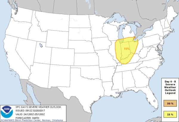
Here in Alabama, the day Friday looks dry and warm with a high well up in the 70s; some spots could touch the 80 degree mark. The trailing cold front will pass through Friday night with a band of showers and storms, but for now the overall severe weather threat looks low with the main dynamic support passing well to the north.
THE ALABAMA WEEKEND: The weather will be dry and cooler; the sky will be mostly sunny both Saturday and Sunday with highs between 62 and 66 degrees for most places. Sunday morning will be pretty chilly with a low in the 30s; colder pockets could see a late season freeze.
NEXT WEEK: The week is looking rather unsettled and stormy with a deep upper trough setting up west of the state. This could open the door for a severe weather threat or two… see the Weather Xtreme video for maps, graphics, and more details. Keep in mind the spring tornado season begins next week.
We should also mention this is severe weather awareness week in Alabama… now is a good time to be sure you can hear warnings (NOAA Weather Radio and a good smart phone app), and review your action plan in case it is needed in coming months.
WEATHER BRAINS: Don’t forget you can listen to our weekly 90 minute netcast anytime on the web, or on iTunes. This is the show all about weather featuring many familiar voices, including our meteorologists here at ABC 33/40. We will produce this week’s show tonight at 8:30 CT… you can watch it live here.
CONNECT: You can find me on all of the major social networks…
Facebook
Twitter
Google Plus
Instagram
Pinterest
Snapchat: spannwx
Look for the next Weather Xtreme video here by 4:00 this afternoon… enjoy the day!
Category: Alabama's Weather
About the Author (Author Profile)
James Spann is one of the most recognized and trusted television meteorologists in the industry. He holds the AMS CCM designation and television seals from the AMS and NWA. He is a past winner of the Broadcast Meteorologist of the Year from both professional organizations.Subscribe
If you enjoyed this article, subscribe to receive more just like it.


