

Strong Storms over Northwest Alabama
Strong storms are over Northwest Alabama this evening.
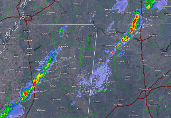
One intense thunderstorm is over eastern Lauderdale County in Northwest Alabama, northwest of Athens. It will clip northwestern Limestone County before passing into Tennessee.
Another storm is over Lawrence County northwest of Moulton.
Not much else going in the state at this hour. There are showers over northern Marion, Franklin and northwestern Winston Counties.
In Mississippi, a decent line of storms now extends from southeast of Oxford to Grenada to east of Greenwood to west of Yazoo City. This main line is moving east at 25 mph. There briefly was a severe thunderstorm warning for Yalobusha County which is just east of I-55 north of Grenada.
The storms over Northwest Alabama will continue into Tennessee. The Mississippi storms will reach Marion County around midnight. They will reach Lamar County a little after midnight. Sumter and Pickens County around 1-2 a.m.
Instabilities are dropping over Northwest Alabama with the loss of the sun. There is quite a bit of speed shear, which is helping the storms. And a strong jet stream wind max is moving in from the west, which is also helping the storms for now. They should begin to go downhill after 10 p.m. annd wll be weakening as they push into West Alabama from Mississippi.
Category: The Attic
About the Author (Author Profile)
Bill Murray is the President of The Weather Factory. He is the site's official weather historian and a weekend forecaster. He also anchors the site's severe weather coverage. Bill Murray is the proud holder of National Weather Association Digital Seal #0001 @wxhistorianSubscribe
If you enjoyed this article, subscribe to receive more just like it.


