

A 7:20 pm Look at the Alabama Weather Situation
After a very warm day that saw every one of the 8 major reporting stations in Alabama except Mobile set a record high for the date, a change to colder is coming.
81s were wild across the northern half of the state, with 81F being reported at Muscle Shoals, Huntsville, Anniston, Birmingham and Tuscaloosa. Montgomery checked in with 83F.
A cold front was approaching Memphis tonight. On this side of the front, temperatures are n the 70s and 60s. At Springdale in the northwestern corner of Arkansas, the temperature was 46F.
The surface low is east of Chicago. In the warm sector, severe thunderstorm watches are in effect for parts of Michigan, Ohio, Indiana and Kentucky. There are a couple of severe thunderstorm warnings in Ohio right now. Hail and wind damage reports have been all we have seen so far.
On the back side of the low, winter weather advisories cover a wide area from the Des Moines area in Iowa to the Upper Peninsula of Michigan. Winter storm warnings remain in effect for extreme northern Wisconsin and Michigan. A blizzard warning remains in effect for parts of Iowa where strong wind is still blowing snow around. 6-12 snowfall amounts are common over Iowa and eastern Nebraska into Minnesota, with reports of over a foot common in southeastern Minnesota.
A few showers broke out over Northwest Alabama about an hour ago, but they have had a hard time holding together with a decent cap in place. The main line of showers and storms was forming from east of Monroe LA to near Greenville in western Mississippi to north of Corinth and on into Kentucky. These showers and storsm will peak over the next three hours and then start to go downhill as they move into Alabama.
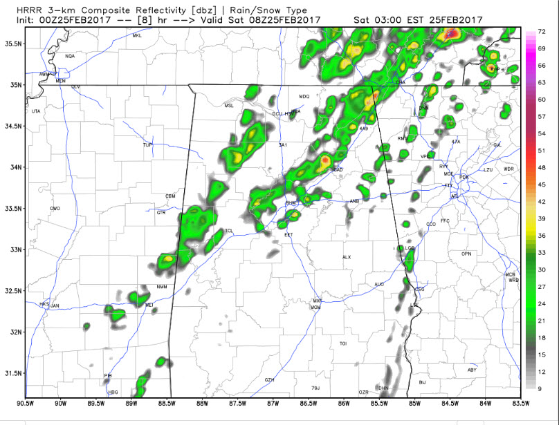
HRRR simulated radar reflectivity for 2 a.m. Saturday morning
The main line will reach the Northwest Corner of Alabama between 9 and 10 p.m. It should reach the I-59 Corridor from Tuscaloosa to Birmingham to Gadsden around 2 a.m. but it is hard to imagine there will be much thunder left in the weakening system. You might get lucky and see some brief heavy rain and gusty winds. A few spots over West Alabama could see some small hail or gusty winds but severe weather isn’t expected.
There will be a few showers out ahead of the main line through the evening hours but they will battle that capping inversion. It will take the forcing of the cold front to trigger storms.
Winds will shift to northwest overnight, first near Hamilton around 1130, Jasper around 1, Tuscaloosa and Birmingham around 2 and Anniston around 330. After that, temperatures will fall into the 40s fairly quickly with gusty winds. Highs on Saturday will struggle to rise into the middle and upper 50s with a biting northwest wind of 10-20 mph and gusts to 25 mph. Skies will become partly cloudy quickly with lots of stratocumulus clouds around.
Lows Saturday night will be chilly, with lows along and north of I-20 ranging between 27-32F. Between I-20 and I-85, lows will range from 32F to 37F. After today’s warmth, that will feel quite chilly. We will be back in the 60s on Sunday.
Category: The Attic
About the Author (Author Profile)
Bill Murray is the President of The Weather Factory. He is the site's official weather historian and a weekend forecaster. He also anchors the site's severe weather coverage. Bill Murray is the proud holder of National Weather Association Digital Seal #0001 @wxhistorianSubscribe
If you enjoyed this article, subscribe to receive more just like it.


