

The Weather Roundup for March 3rd, 2017
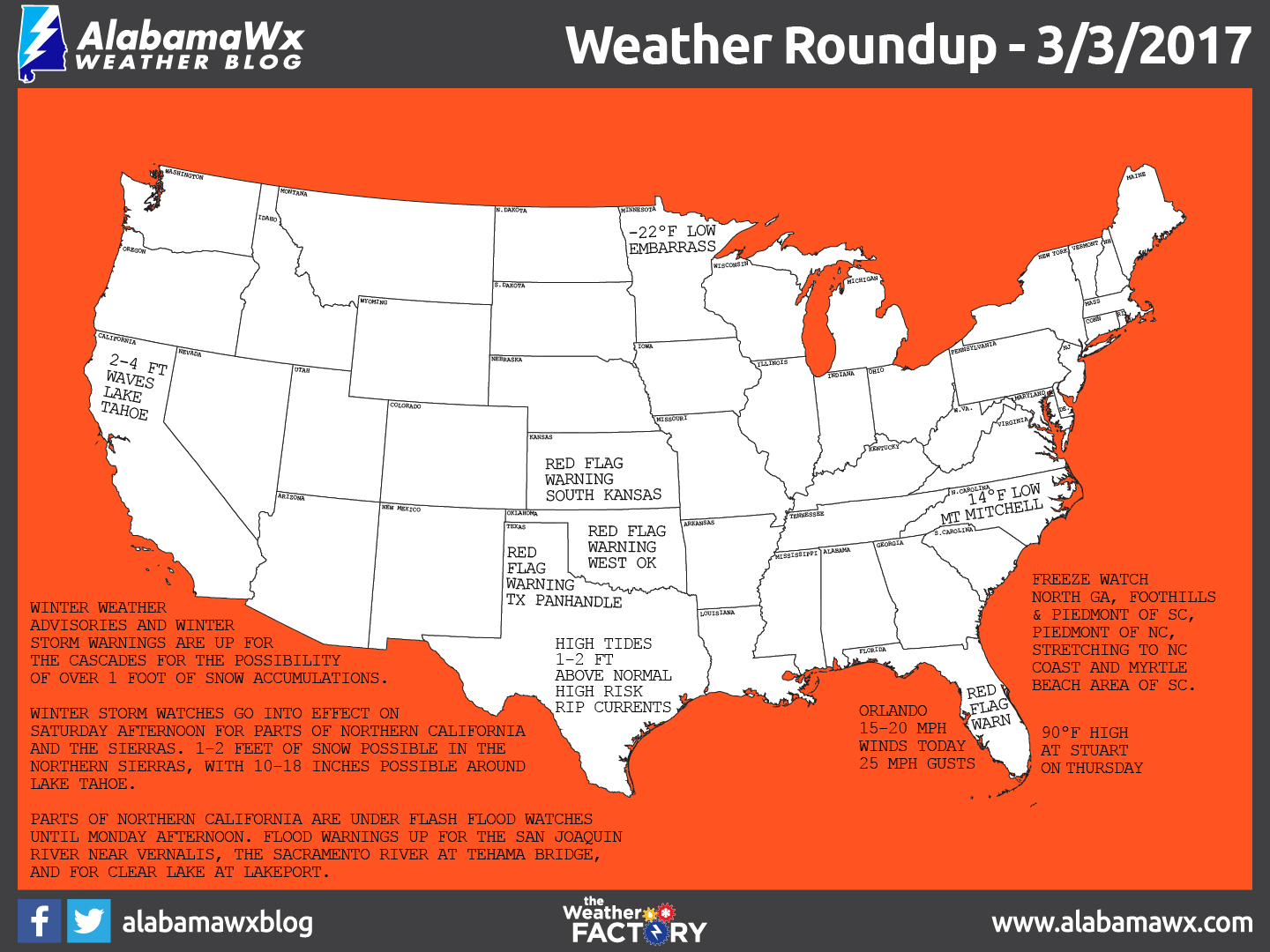
It was a chilly morning this morning across the Foothills and Piedmont of Northeast Georgia and the Carolinas, where a widespread freeze occurred. Places like Lenoir (31F), Boone (29F) and Bryson City (26F) all recorded freezes. It was 14F atop Mt. Mitchell and 18F at Beech Mountain. A big trough across the eastern half of the nation has ushered in this cold weather.
The freeze worries shift southward for tonight, with freeze warnings now posted for the rest of North Georgia, the Foothills and Piedmont of South Carolina and the Piedmont of North Carolina. A freeze watch goes all the way to the North Carolina Coast and the Myrtle Beach area of South Carolina.
Red flag warnings are posted over a wide area of the Plains, including much of western Oklahoma, southern Kansas and the Texas Panhandle, where strong winds ahead of our next storm system and low humidities of 10% or less will lead to a high danger of wildfires today.
Red flag warnings are up now for much of Central Florida as well. It will be a beautiful day for spring training baseball at Disney’s Wide World of Sports Complex in Orlando when the Braves host the Red Sox at 1:30, but the wind will be blowing 15-20 mph with gusts to 25 mph out of the northeast, of from left to right field. Temperatures will be in the middle 70s, but will feel chillier because of the wind.
Blizzard warnings are in effect along the Beaufort Sea Coast along the North Slope of Alaska. But for only 2 inches of snow. Whaaaat? Well, you have to look at the definition of a blizzard. ‘A blizzard is a severe snow storm with strong winds that cause blowing snow that results in low visibiities. To be a blizzard, you have to have sustained winds or frequent gusts that are greater than or equal to 35 mph with blowing or drifting snow that reduces visibilities to ¼ mile or less. These conditions must last for three hours or more. They will have that with winds gusting to 45 mph for much of the day and wind chills of -50F.
Out on the west coast, a low moving inland over British Columbia will be dragging a cold front across much of the Pacific Northwest and northern California. This will bring more rain over the Pacific Coasts of Washington, Oregon, and northern California. Along with the rain, Winter Weather Advisories and Winter Storm Warnings have been issued for the Cascades due to this system, and the possibility of snow accumulations over 1 foot.
2 to 3 feet of snow is expected on Mount Baker and at Paradise on Mt. Rainier. Snow levels are expected to drop to 1,500 feet.
Winter Storm Watches are also in effect for much of Northern California and the Sierras starting on Saturday afternoon and lasting through Sunday night. 1-2 feet of snow may fall in the northern Sierras with 10-18 inches around Lake Tahoe. Wave heights on the lake are expected to reach 2-4 feet!
Just a little to the south, parts of the northern half of California are under Flash Flood Watches through part of the day on Monday, with Flood Warnings for the San Joaquin River near Vernalis, the Sacramento River at Tehama Bridge, and for Clear Lake at Lakeport.
Surf’s up along the Texas coast thanks to the big high pressure area over the Ohio Valley. Winds blowing clockwise around the big high are push Gulf water against the Lower Texas Coast. High tides of 1-2 feet above normal will overwash the beaches and reach the dune level. There is a high risk of rip currents as well.
About the Author (Author Profile)
Scott Martin is an operational meteorologist, professional graphic artist, musician, husband, and father. Not only is Scott a member of the National Weather Association, but he is also the Central Alabama Chapter of the NWA president. Scott is also the co-founder of Racecast Weather, which provides forecasts for many racing series across the USA. He also supplies forecasts for the BassMaster Elite Series events including the BassMaster Classic.Subscribe
If you enjoyed this article, subscribe to receive more just like it.


