

Strong Storms For Far North Alabama Later Today
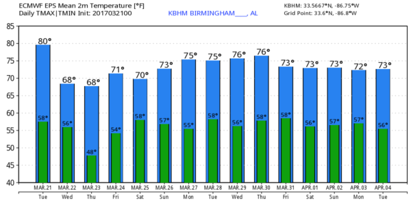
ANOTHER WARM EARLY SPRING DAY: Birmingham’s official high yesterday was 83 degrees… within a few degrees of the record high for March 20, 87 set in 1907. We go back into the 80s today, but Birmingham’s record will be safe (it was 90 degrees on March 21, 1907, our record today). The sky will be partly sunny, and most of the day will be dry.
However, a surface front over Tennessee will push southward this afternoon, and a band of strong to severe storms will clip far North Alabama this evening. SPC maintains the standard “slight risk” for the Tennessee Valley region of North Alabama, with a “marginal risk” down to Cullman and Gadsden…
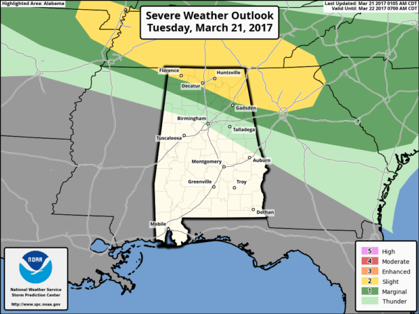
Storms over far North and Northeast Alabama this evening could produce hail and strong winds; the tornado threat is very low due to relatively weak wind fields. The main window for stronger storms will come from 5:00 until 8:00 p.m.
TOMORROW/THURSDAY: The surface front will sag slowly southward across Alabama, and we expect a slow cooling trend with a high back in the 70s tomorrow, and 60s Thursday. We will mention just a small risk of a shower tomorrow, but scattered showers seem to be a little more likely Thursday as the surface front begins to push northward as a warm front.
For now Friday looks rain-free with a decent amount of sun, and a high close to 70 degrees, pretty close to average for late March in Alabama.
STORMY WEEKEND: A surface low, with good upper air support, will move from Kansas to near Chicago, and Alabama will be in the “warm sector” meaning potential for stormy weather over the weekend. The GFS is a little slower in the arrival of the rain, now suggesting it might be late Saturday or Saturday night before showers and storms arrive in Alabama. The reliable European model still shows a chance of showers and storms as early as Saturday afternoon. Both models hint the rain will continue into at least part of the day Sunday.
Due to the uncertainly of the timing, SPC has pulled Alabama out of the severe weather risk area for Saturday for now… showing the threat just to the west on the their “Day 5” outlook…
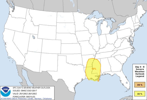
The bottom line is that strong to severe storms are possible across Alabama at some point over the weekend, but confidence is low for now on the timing, or magnitude of the threat. See the Weather Xtreme video for maps, graphics, and more details.
NEXT WEEK: A few scattered showers are possible Monday and Tuesday, and it looks like a stronger system will impact the state later in the week with some potential for strong storms by Thursday or Friday.
Click here to see the Beach Forecast Center page. Save Up To 25% on Spring Break Beach Vacations on the Alabama Gulf Coast with Brett/Robinson! The Beach Forecast is partially underwritten by the support of Brett/Robinson Vacation Rentals in Gulf Shores and Orange Beach. Click here to see Brett/Robinson’s best beach offers now!.
STORM SPOTTER TRAINING TONIGHT IN CLAY COUNTY: We will be on the road through early April offering free storm spotter classes. We need more trained spotters in Alabama; by attending you can make the severe weather warning process better. No need to register; just come with a curious mind. And, there is no age limit… kids that love weather will enjoy it. You will never look at a storm the same again. The next class will is this evening in Lineville at the Clay County Farmers Market on Highway 9; it begins at 6:30.
ON THIS DATE IN 1932: It was Alabama’s deadliest tornado outbreak; the records show that 268 died in Alabama March 21, 1932, but I suspect the death toll was much, much higher. One long track, F-4 tornado tore through the western part of Tuscaloosa and into Northport killing 37. Forming 30 minutes after the Tuscaloosa tornado, the deadliest tornado of the outbreak carved a path 60 miles long southeast of Birmingham across Perry, Bibb, Chilton, Shelby, and Coosa counties. Also the longest-tracked single tornado to touch down this day, it was followed an hour later by another F4 tornado, on a path 8 miles to the southeast. Each killed an estimated 19 people in Chilton County alone. The first, earlier event killed 21 people, including entire families, near the town of Jemison and in the Union Grove community, both in Chilton County.
WEATHER BRAINS: Don’t forget you can listen to our weekly 90 minute netcast anytime on the web, or on iTunes. This is the show all about weather featuring many familiar voices, including our meteorologists here at ABC 33/40.
CONNECT: You can find me on all of the major social networks…
Facebook
Twitter
Google Plus
Instagram
Pinterest
Snapchat: spannwx
I have weather programs today at Madison Academy near Huntsville, and at McElwain Christian Academy in Birmingham. Look for the next discussion here by 4:00 this afternoon… enjoy the day!
Category: Alabama's Weather, ALL POSTS
About the Author (Author Profile)
James Spann is one of the most recognized and trusted television meteorologists in the industry. He holds the AMS CCM designation and television seals from the AMS and NWA. He is a past winner of the Broadcast Meteorologist of the Year from both professional organizations.Subscribe
If you enjoyed this article, subscribe to receive more just like it.


