

Severe Storms Over North Alabama; Storms Intensifying Over Eastern Mississippi As Well
LATE REPORT
Golfball size hail was just reported in Curry in Walker County at 445 p.m. A severe thunderstorm warning is in effect for Walker and Cullman Counties.
SEVERE STORMS CONTINUE
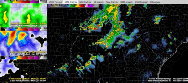
Strong to severe storms continue across Northwest and North Central Alabama at this hour. Everything is moving northeast.
That one severe storm is moving from Walker into Cullman County. It has large hail in it.
Severe storms continue from north of Hamilton to Phil Campbell and back into Winston County.
Additional severe storms are in the Athens/Decatur area and north of Hazel Green in Madison County.
To the southwest, severe storms are over eastern Mississippi from DeKalb back to Newton. These storms will push into West Alabama’s Pickens and Sumter Counties between 6 p.m. and 7 p.m.
SEVERE ENVIRONMENT
There is still substantial instability across Alabama, especially in areas east of I-65, so the storms should continue to maintain or strengthen over the next 2-3 hours before slowly diminishing later this evening. Instability values are running 1,000-1,5000 joules west of I-65 and 1,500 to 2,000 joules east of I-65.
There is a substantial threat of large hail and damaging winds are also possible. Hail may reach 1.5-2 inches, or ping pong ball to egg sized.
There is still 45 knots of effective shear across North and Central Alabama, especially along I-65 so the storms will remain organized. The left entrance region of a 250 millibar jet, up at about 32,000 feet, is trying to nose into North Alabama which is helping the storms stay strong as well.
There is a weak 850 mb jet over Northeast Mississippi and Northwest Alabama. It will move eastward across North and North Central Alabama over the next few hours, helping to maintain the damaging wind threat.
A weak surface low is near Memphis. Lots of severe storms from western Kentucky into western Tennessee. That weak surface low will help to maintain a tornado threat, mainly across western Tennessee into Northwest Alabama. Storm relative helicity values are 50-100 m2/s2 across North Alabama right now, which is fairly low, but could increase over the next couple of hours.
Our shortwave trough is moving eastward. The axis of the trough extends across Illinois and Missouri.
About the Author (Author Profile)
Bill Murray is the President of The Weather Factory. He is the site's official weather historian and a weekend forecaster. He also anchors the site's severe weather coverage. Bill Murray is the proud holder of National Weather Association Digital Seal #0001 @wxhistorianSubscribe
If you enjoyed this article, subscribe to receive more just like it.


