

Strong Storms Moving Across Central Alabama
Strong storms are moving across Central Alabama this evening.
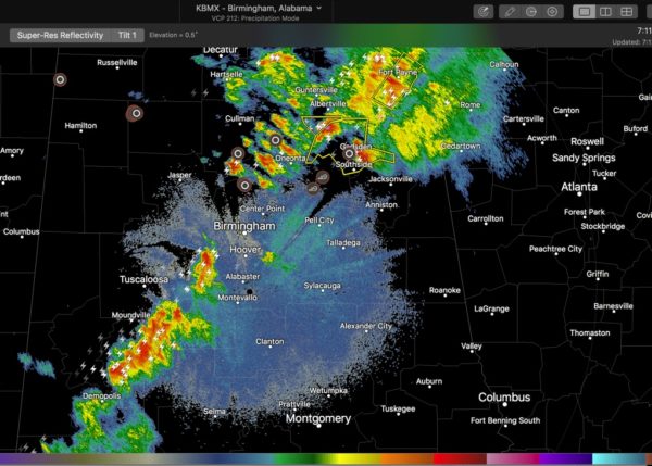
At 710 p.m. they extended across parts of Hale and Tuscaloosa Counties. moving into Bibb and Jefferson Counties.
There is an isolated storm over northern Shelby County as well, but it has weakened in the past few minutes.
They are not severe at this time, but could become severe with little or no notice so they are being monitored closely.
They still have a pool of 1,000+ joules/kg of CAPE to draw on and good lapse rates, so they should hold together or intensify. They have been moving out from under a little convective inhibition as well.
This means small hail and wind gusts to 40 mph as well as lots of lightning. Lots of lightning too. In fact, the lightning has increased in the past 30 minutes substantially. And be prepared in case they intensify.
Be indoors as these storms approach.
To the north, severe thunderstorm warnings continue for parts of Etowah, Cherokee and DeKalb Counties. Golf ball sized hail was reported in Gadsden at 701 p.m.
Category: ALL POSTS, Severe Weather
About the Author (Author Profile)
Bill Murray is the President of The Weather Factory. He is the site's official weather historian and a weekend forecaster. He also anchors the site's severe weather coverage. Bill Murray is the proud holder of National Weather Association Digital Seal #0001 @wxhistorianSubscribe
If you enjoyed this article, subscribe to receive more just like it.


