

Storm That Moved Through Birmingham Caused Damage on East Side of Town
813PM
Tree reported on car in 7700 block of 1st Avenue South according to John Talbot. One person injured.
Interestingly, no strong wind gust at the airport, but Doppler radar clearly showed winds of 56 mph moving through the East Lake/Woodlawn areas.
807PM
Birmingham FD reporting live wires down at Oporto Madrid Blvd and 73rd Street.
743PM
Doppler radar shows winds of 55 mph approaching the Roebuck area along I-59. Be in a safe place across eastern Jefferson County as these storms approach!
REPORT FOM JOHN TALBOT
725pm – Tree and power lines down: Longview Dr & Crescent Dr in S Hueytown. FD has road blocked.
ORIGINAL POST
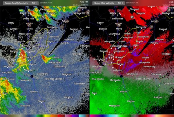
As we expected they might, the storms moving into Jefferson County have intensified.
Be ready for damaging winds of 60 mph and 1 inch hail.
There have been reports of power flashes west of Birmingham.
The storm will impact everything from Downtown Birmingham through Hoover along I-65 northeastward through the Airport, Tarrant, Roebuck, Center Point, Trussville, Irondale, Mountain Brook, Vestavia Hills, Cahaba Heights and into Leeds.
Be in a safe place as these dangerous storms move through.
Lots of dangerous lightning and brief heavy rain as well.
Category: Alabama's Weather, ALL POSTS
About the Author (Author Profile)
Bill Murray is the President of The Weather Factory. He is the site's official weather historian and a weekend forecaster. He also anchors the site's severe weather coverage. Bill Murray is the proud holder of National Weather Association Digital Seal #0001 @wxhistorianSubscribe
If you enjoyed this article, subscribe to receive more just like it.


