

Severe Storms Possible Later Today/Tonight
COMPLEX SETUP: There is a risk of severe weather statewide today as a large scale upper trough approaches from the west. A surface low will be near St. Louis this afternoon, and all of Alabama is in the “warm sector” of the system. While the synoptic scale pattern favors severe storms, the mesoscale features will determine what ultimately happens.
We have an area of rain and storms over Southeast Mississippi early this morning, and that will move into South Alabama in a few hours. There is a chance this will disrupt the inflow of warm, moist air into the northern half of the state, and also reducing the instability due to clouds and limited surface heating today. This, in turn, would result in a lowered overall severe weather threat.
UPDATE: SPC has now removed the “enhanced risk” for Northwest Alabama… we have a “slight risk” for all 67 Alabama counties…
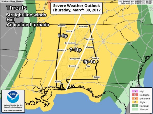
THREATS: Stronger storms later today and tonight will be capable of producing hail and strong straight line winds. An isolated tornado or two is still possible.
TIMING: The primary severe weather threat for Northwest Alabama will come from 5 until 9pm… for places like Birmingham, Tuscaloosa, Anniston, and Gadsden, the main window will be from 7-11pm… and for East Alabama from 9pm until 2am.
RAIN: Rain amounts of 1/2 to 1 inch are expected; no flooding issues.
CALL TO ACTION: Be sure you have a way of getting warnings; a NOAA Weather Radio is the baseline, and a good smart phone app is the other tier. Identify the safe place in your home, and be sure everyone knows where it is. And, in that safe place have helmets for everyone, along with hard sole shoes and preferably a portable airhorn in case you need help.
Be sure you have the ABC 33/40 app on your phone so you can watch our live severe weather coverage, if needed:
Rain and storms end late tonight as drier air pushes into the state.
TOMORROW THROUGH SUNDAY: Tomorrow and Saturday will be delightful spring days, with ample sunshine. The high tomorrow will be in the mid 70s, and close to 80 Saturday afternoon. We project a mix of sun and clouds Sunday with a high between 77 and 80; showers and storms could creep into the state Sunday night.
NEXT WEEK: Rain and storms are likely Monday; the latest GFS run suggests the surface low will pass across Central Alabama; if that is the case the main severe weather threat will be near the Gulf Coast, although North Alabama could see heavy rain. This could easily change, however… just too early to be specific. And, yet another chance of strong storms shows up late Wednesday and Wednesday night as the wave train keeps cranking out the hits. See the Weather Xtreme video for maps, graphics, and more details.

Click here to see the Beach Forecast Center page. Save Up To 25% on Spring Break Beach Vacations on the Alabama Gulf Coast with Brett/Robinson! The Beach Forecast is partially underwritten by the support of Brett/Robinson Vacation Rentals in Gulf Shores and Orange Beach. Click here to see Brett/Robinson’s best beach offers now!.
STORM SPOTTER TRAINING: We will be on the road through April offering free storm spotter classes. We need more trained spotters in Alabama; by attending you can make the severe weather warning process better. No need to register; just come with a curious mind. And, there is no age limit… kids that love weather will enjoy it. You will never look at a storm the same again. The next training is in Tuscaloosa Tuesday evening (April 4) at 6:30 at Shelton State Community College.
WEATHER BRAINS: Don’t forget you can listen to our weekly 90 minute netcast anytime on the web, or on iTunes. This is the show all about weather featuring many familiar voices, including our meteorologists here at ABC 33/40.
CONNECT: You can find me on all of the major social networks…
Facebook
Twitter
Google Plus
Instagram
Pinterest
Snapchat: spannwx
I am speaking this morning at Saint Patrick Catholic Church in Adamsville… look for the next Weather Xtreme video here by 4:00 this afternoon. Enjoy the day!
Category: Alabama's Weather, ALL POSTS
About the Author (Author Profile)
James Spann is one of the most recognized and trusted television meteorologists in the industry. He holds the AMS CCM designation and television seals from the AMS and NWA. He is a past winner of the Broadcast Meteorologist of the Year from both professional organizations.Subscribe
If you enjoyed this article, subscribe to receive more just like it.


