

Severe Threat Late This Afternoon and Evening
Lots of activities going on this weekend across Central Alabama, and wouldn’t you know, a threat for severe weather as well. The good news is that the major outdoor events today and tomorrow should be ok. Let’s dig into the details.
NICE MORNING: This busy Saturday is getting off to a very nice start for much of Central Alabama. Temperatures are in the middle and upper 60s with a partly cloudy sky. The only exception is over South Central and West Central Alabama where clouds are a little thicker. A diminishing line of showers is over Northwest Alabama.
The air is beginning to have that muggy feel, with dewpoints around 60F. Winds re light out of the south. Those winds will begin picking up as we go through the morning and temperatures will rise quickly through the 70s, heading for highs in the lower 80s.
LET’S GO TO THE MAPS: At the Jetstream level, a trough of low pressure is pushing eastward through the Central Plains states. This trough brought severe weather to the Plains on Friday and Friday evening. Yesterday morning’s storms dissipated over North Alabama overnight and last evening’s storms will dissipate to the north this morning. At the surface, we find a weak surface low over Arkansas. This low will track eastward slowly today, firing a line of showers and storms near the Mississippi River around noon. This line of storms will grow as It progresses eastward, reach West Alabama around 4 p.m. The storms should reach the I-59 Corridor between 5-9 p.m. and be into East Alabama between 7-11 p.m.
HONDA INDY GRAND PRIX: Huge crowds out at Barber today and tomorrow for the huge race weekend. The good news is that Most of today’s activities should be dry. It will be quite pleasant; breezy, warm and partly sunny. Take your sunscreen and a hat. Clouds will thicken by mid-afternoon and a shower could show up before the last race is done at 630 p.m. Tomorrow, expect showers, especially for the morning races. Most of the rain should be gone, should by the main event, the Honda Indy Grand Prix of Alabama, which goes off at 2:30 p.m. The morning event could deal with a little light rain or showers. It will be noticeably cooler and breezy as well, with a brisk west wind and temperatures holding in the 60s. Places north of Birmingham may stay in the 50s all day!
IT’S THAT TIME AGAIN! The Honda Indy Grand Prix continues today and tomorrow at the beautiful Barber Motorsports Park! Make plans for the event that has been voted “Best Annual Event” & “Best Sporting Event” in Birmingham. Kids 15 & under are admitted free with a ticketed adult, and three-day general admission tickets are $69. Single day tickets are $15. Pack a picnic/cooler and bring the family out for a weekend full of activities and racing! Get tickets and more information here. Get the detailed race cast here.
ALABAMA A-DAY: The Crimson Tide’s Spring Football Game is today at Bryant-Denny Stadium. Again, the pre-game will be nice, with a mix of sun and clouds, warm temperatures and a balmy southerly breeze. The kick off temperature will be around 82F, peaking about there. The bulk of the game will be dry. There is a chance of a shower or storm during the second half. Alabama’s Chief Meteorologist James Spann will be on site monitoring the weather throughout the game and communicating with University officials, who have a great severe weather plan.
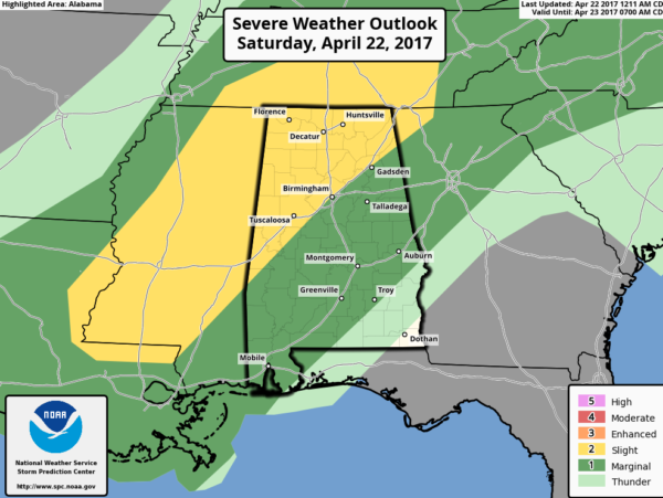
SEVERE WEATHER THREAT: The SPC has much of the northwestern half of Alabama, generally along and northwest of I-59 in a slight risk severe weather outlook for today and this evening The good news is that the tornado threat looks to be nearly zero. The main threat will come from the afternoon and evening storms in the form of damaging winds or hail. Rainfall amounts should average around ½ inch, with some 1 inch amounts possible. We can use the rain. Birmingham has been sixteen days without measurable rain, which has actually worsened our drought conditions.
NEW WEEK: Ok, I have already told you that Sunday will breezy and much cooler with showers especially during the morning. Lows Monday morning will be airish, in the 40s in most locations. Dry with a warming trend for the rest of the week. Highs will be back in the 70s on Monday then 80s the rest of the week.
WEKEEND SNEAK PEEK: Looks wet for next weekend, probably coming in a couple of different waves. Rainfall amounts could be healthy, around an inch for most folks, with heavier amounts to the northwest. Another cool spell will follow that system. There could be some late season frost in the Central Plains and Ozarks of Arkansas on Monday morning the 1st of May. We could see 40s over North Alabama. That’s not that unusual: we’ve seen lows in the 30s many times in early May.
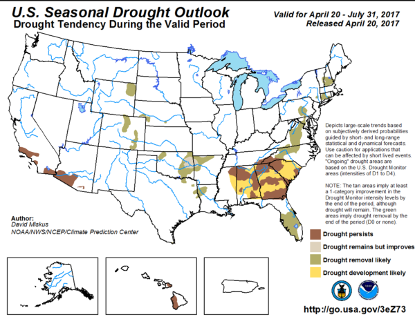
DROUGHTWATCH: Don’t look for drought conditions to improve over the next 90 days. The official Climate Prediction Center outlook over the May, June and July time frame shows prospects for worsening drought over much of Alabama, in keeping with the signals that we have been seeing from the longer range climate prediction models. Great. Someone told me yesterday he was giving up gardening. Nah, I told him. We can’t do that! We love it too much.
TROPICS: We said goodbye to the short lived Arlene yesterday, only the second known tropical storm to have ever occurred in the Atlantic in April. The Atlantic hurricane season doesn’t officially kick off until June 1.
GULF COAST WEATHER: Showers tonight and early Sunday, then gorgeous for the rest of the week. Highs all week will be in the upper 70s to lower 80s. lows will be in the 60s. Water temperatures are now in the upper 70s.
Click here to see the Beach Forecast Center page. Save Up To 25% on Spring Break Beach Vacations on the Alabama Gulf Coast with Brett/Robinson! The Beach Forecast is partially underwritten by the support of Brett/Robinson Vacation Rentals in Gulf Shores and Orange Beach. Click here to see Brett/Robinson’s best beach offers now!.
DANCING WITH THE STATS: It’s official, the 2016-17 water season in the northern Sierra of California is the wettest in history, surpassing the 1982-83 season. The 8 station Northern Sierra index now stands at 92.4 inches, smashing the previous Oct 1-Sep 30 total which was 88.5 inches. Could they break 100 inches? They generally see another 6 inches between mid-April and the end of September.
ADVERTISE WITH US: Deliver your message to a highly engaged audience by advertising on the AlabamaWX.com website. The site has enjoyed over 6.8 million pageviews since January 1st. Don’t miss out! We can customize a creative, flexible and affordable package that will suit your organization’s needs. Contact me, Bill Murray, at (205) 687-0782 and let’s talk.
WEATHERBRAINS: This week, the panel will entertain Dr. Shawn Miller from the AMS. We will be talking about weather and government. Check out the show at www.WeatherBrains.com. You can also subscribe on iTunes. You can watch the show live at live.bigbrainsmedia.com You will be able to see the show on the James Spann 24×7 weather channel on cable or directly over the air on the dot 2 feed.
ON THIS DATE IN 1997: A mid-afternoon F2 tornado struck the small northeast Alabama town of Rainsville without warning, injuring 12 people. Over 30 homes were damaged by the twister and 50 buildings in the small town received damage, including the city and police and fire stations. No tornado warning was in effect at the time of the storm since NWS Doppler radar did not show significant signs of storm rotation. Ironically, a more powerful Doppler radar was being prepared for installation, very near the location of the tornado at Hytop. It probably would have made a difference. Follow my weather history tweets on Twitter. I am @wxhistorian at Twitter.com.
Category: Alabama's Weather, ALL POSTS, Weather Xtreme Videos
About the Author (Author Profile)
Bill Murray is the President of The Weather Factory. He is the site's official weather historian and a weekend forecaster. He also anchors the site's severe weather coverage. Bill Murray is the proud holder of National Weather Association Digital Seal #0001 @wxhistorianSubscribe
If you enjoyed this article, subscribe to receive more just like it.


