Showers and Storms Developing Across West Alabama
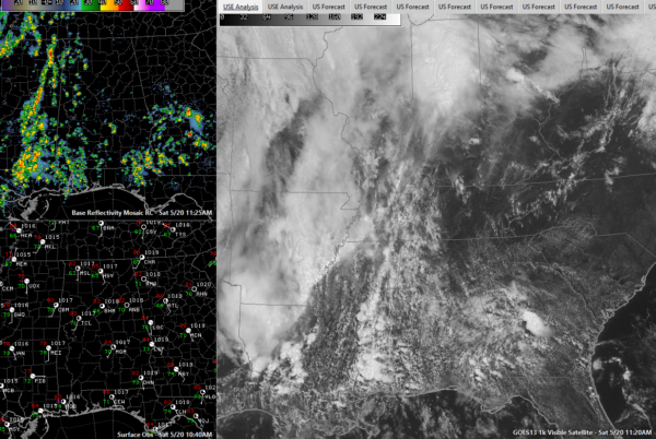
Showers have developed over West Alabama and eastern Mississippi late this morning ahead of an approaching trough in an increasing flux of moisture out of the Gulf of Mexico.
There is not much lightning in Alabama yet, but several storms have developed in eastern and southern Mississippi.
There is just enough wind shear to keep the storms from choking on their own downdrafts and the light south southwesterly flow is pushing them north northeast at 20 mph.
There is a moderate amount of instability to power the storms and the approaching trough is providing the spark.
The showers ands storms will continue to grow in grow in coverage and intensity through the afternoon, but light shear and weak mid-level lapse rates should keep them under control.
Showers and storms leftover from last night’s event in the Plains are approaching the Mississippi River as we approach lunch time. These storms could become severe later this afternoon, with better wind shear available. They will likely limp into Alabama in a weakening state this evening. There is a slight risk of severe thunderstorms over Northwest Alabama according to the SPC with a marginal risk over the rest of the state. The main threat is from damaging winds. It’s hard for me to imagine a tornado threat, although the SPC does have the slight risk area in a 5% chance of tornadoes. The hail threat is minimal, since the freezing level is over 15,000 feet. That’s just too high for a hailstone to reach the ground before melting.
Category: Alabama's Weather, ALL POSTS
About the Author (Author Profile)
Bill Murray is the President of The Weather Factory. He is the site's official weather historian and a weekend forecaster. He also anchors the site's severe weather coverage. Bill Murray is the proud holder of National Weather Association Digital Seal #0001 @wxhistorianSubscribe
If you enjoyed this article, subscribe to receive more just like it.


