Storms Approaching Shelby County from the South
Showers and storms continue to develop early this afternoon across Alabama and Mississippi.
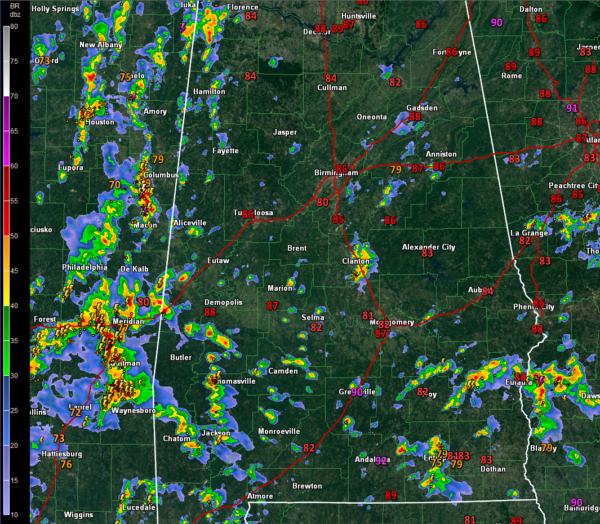
The greatest concentration has been along the Alabama/Mississippi border and over eastern Mississippi, where some pretty heavy downpours and lots of lightning is occurring. This activity extends back into Southwest Alabama and just curves into extreme Northwest Alabama.
This activity will gradually spread over West Alabama through the afternoon hours.
Scattered storms are over the rest of Central Alabama. One of the main clusters is over northern Autauga and southeastern Chilton County. It is moving north northeast and will impact eastern Shelby County over the next hour.
Some showers have been affecting the Regions Classic out at Greystone, but the rain has been relatively brief. The storms over Chilton County could affect the course before 3 p.m. with a more extended period of rain and lightning.
Be alert for storms in your area. Look for darkening skies and keep an eye on the radar.
The prefrontal activity in western Mississippi has weakened and the activity over eastern Mississippi will likely become the main event as we head into the evening hours as a weak surface flow move northeast into northern Mississippi.
Category: Alabama's Weather, ALL POSTS
About the Author (Author Profile)
Bill Murray is the President of The Weather Factory. He is the site's official weather historian and a weekend forecaster. He also anchors the site's severe weather coverage. Bill Murray is the proud holder of National Weather Association Digital Seal #0001 @wxhistorianSubscribe
If you enjoyed this article, subscribe to receive more just like it.


