

The Latest On Tropical Storm Bret
As of the 10AM CDT public advisory, the center of Tropical Storm Bret was located around 315 miles to the east of Curacao, and is moving to the west-northwest at approximately 21 MPH. Maximum sustained winds at that point were 45 MPH, and the minimum central pressure is around 1008 mb (29.77 inHg).
A Tropical Storm Warning is up for Margarita Island, while a Tropical Storm Watch is in effect for Bonaire, Curacao, and Aruba. The Venezuelan government had discontinued the Tropical Storm Warning from Pedernales to Cumana.
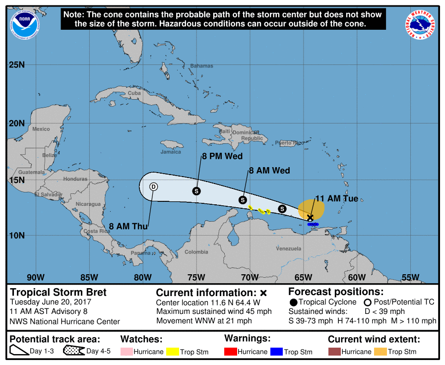
The latest thoughts on Bret will have it weakening within the next couple of days to a depression as it gets closer to Central America, but for now it is forecast to stay as a tropical storm until at least Wednesday night and into Thursday morning. Even with that being said, Bret is still capable of producing rainfall totals of 2-4 inches over the Windward Islands and the northeastern coast of Venezuela throughout the rest of the day today.
Here is the public advisory from the National Hurricane Center…
BULLETIN
Tropical Storm Bret Advisory Number 8
NWS National Hurricane Center Miami FL AL022017
1100 AM AST Tue Jun 20 2017
…BRET FORECAST TO WEAKEN AS IT MOVES ACROSS THE EASTERN CARIBBEAN
SEA…
SUMMARY OF 1100 AM AST…1500 UTC…INFORMATION
———————————————–
LOCATION…11.6N 64.4W
ABOUT 315 MI…505 KM E OF CURACAO
MAXIMUM SUSTAINED WINDS…45 MPH…75 KM/H
PRESENT MOVEMENT…WNW OR 290 DEGREES AT 21 MPH…33 KM/H
MINIMUM CENTRAL PRESSURE…1008 MB…29.77 INCHES
WATCHES AND WARNINGS
——————–
CHANGES WITH THIS ADVISORY:
The Government of Venezuela has discontinued the Tropical Storm
Warning from Pedernales to Cumana.
SUMMARY OF WATCHES AND WARNINGS IN EFFECT:
A Tropical Storm Warning is in effect for…
* Venezuela Isla de Margarita
A Tropical Storm Watch is in effect for…
* Bonaire
* Curacao
* Aruba
For storm information specific to your area, please monitor products
issued by your national meteorological service.
DISCUSSION AND 48-HOUR OUTLOOK
——————————
At 1100 AM AST (1500 UTC), the center of Tropical Storm Bret was
located near latitude 11.6 North, longitude 64.4 West. Bret is
moving toward the west-northwest near 21 mph (33 km/h), and this
motion is expected to continue through tomorrow. On the forecast
track, the center of the tropical storm or its remnants will
continue to move across the southeastern Caribbean Sea for the next
couple of days.
Maximum sustained winds are near 45 mph (75 km/h) with higher gusts.
Weakening should begin today, and the system is expected to
dissipate on Thursday.
Tropical-storm-force winds extend outward up to 125 miles (205 km)
to the north of the center.
The estimated minimum central pressure is 1008 mb (29.77 inches).
HAZARDS AFFECTING LAND
———————-
WIND: Tropical storm conditions are occurring over portions of the
warning area, but these conditions should subside later today.
Tropical storm conditions are possible within the watch area by
tonight and Wednesday.
RAINFALL: Bret is expected to produce total rain accumulations of 2
to 4 inches over the Windward Islands and the northeastern coast of
Venezuela through today.
About the Author (Author Profile)
Scott Martin is an operational meteorologist, professional graphic artist, musician, husband, and father. Not only is Scott a member of the National Weather Association, but he is also the Central Alabama Chapter of the NWA president. Scott is also the co-founder of Racecast Weather, which provides forecasts for many racing series across the USA. He also supplies forecasts for the BassMaster Elite Series events including the BassMaster Classic.Subscribe
If you enjoyed this article, subscribe to receive more just like it.


