

7 p.m. Update: Cindy Still Meandering Over The Central Gulf
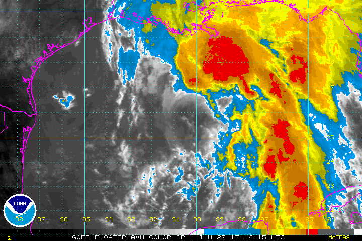
Not much change in the status or organization of Tropical Storm Cindy tonight. An upper low near the Texas coast has delivered dry air out of the arid Southwest U.S. and produced significant wind shear over the western half of the storm and preventing it from developing quickly.
The shear may relax enough late tonight and Wednesday to allow for some strengthening of the system, but it not not seem that it will be significant.
Already, better outflow over the northern Gulf is enhancing thunderstorms there, and wind gusts to tropical storm force have been being reported all day from oil rigs off the Louisiana coast. There was even a gust to 68 mph.
The Air Force plane just coming on station near the Center has encountered widespread 40+ knot winds at flight level over a large distance northeast of the center. The last plane encountered an area of 50+ knot winds south of the Mouth of the Mississippi River. So while the storm is not getting better organized, widespread tropical storm force winds are occurring north of the center.
Heavy rain has spread onshore over Southeast Louisiana, southern Mississippi, southern Alabama, southwestern Georgia and the Florida Panhandle. Rainfall rates of up to three inches per hour are possible in the stronger convection. Flash flood watches are in effect.
The NWS in Mobile has placed coastal Alabama and their southern Mississippi counties in an extreme risk for flash flooding over the next three days. They warn that widespread, potentially life threatening flash flooding will be possible over their area through Thursday. 10-12 inches could fall over coastal Mississippi and Alabama with 5-8 inches over the rest of southeastern Louisiana, southeastern Mississippi, southwestern Alabama and extreme Northwest Florida.
Surf of 6-10 feet will be affecting the beaches of Alabama and Northwest Florida and double red flags are flying on most beaches, meaning no one in the water.
Surge of 1-3 feet will impact the coast including beaches, bays and sounds during high tides all along the coast from the Upper Texas Coast to the Florida Panhandle.
Isolated brief tornadoes are possible tonight near the coast of Alabama, Mississippi and over southeast Louisiana. The severe weather threat will extend westward to the Texas line tomorrow and then will start to spread north and northeast on Thursday and Friday, even affecting us here in North and Central Alabama.
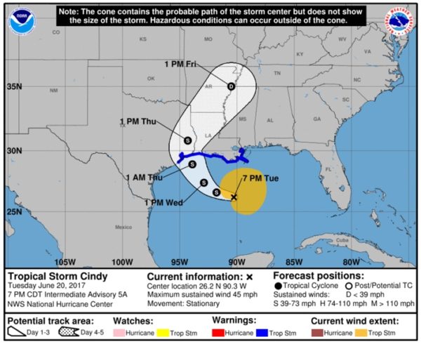
The storm has been basically describing a loop over a small area, making it essentially stationary. It should begin moving northwest later tonight. Tropical storm force winds will affect the southern Louisiana into Southwest Louisiana and the extreme southeastern corner of Texas around Beaumont and Port Arthur.
FAST FACTS AS OF 7 PM
———————————————-
Location…26.2n 90.3w
About 250 Mi…400 Km Sse Of Morgan City Louisiana
About 350 Mi…560 Km Se Of Galveston Texas
Maximum Sustained Winds…45 Mph…75 Km/h
Present Movement…stationary
Minimum Central Pressure…997 Mb…29.44 Inches
WATCHES AND WARNINGS
——————–
CHANGES WITH THIS ADVISORY:
None.
SUMMARY OF WATCHES AND WARNINGS IN EFFECT:
A Tropical Storm Warning is in effect for…
* San Luis Pass to the Mouth of the Pearl River
A Tropical Storm Warning means that tropical storm conditions are
expected somewhere within the warning area, in this case within the
next 24 to 36 hours.
Interests elsewhere along the U.S. Gulf Coast from the central Texas
coast to the western Florida Panhandle should monitor the progress
of this system.
For storm information specific to your area, including possible
inland watches and warnings, please monitor products issued by your
local National Weather Service forecast office.
DISCUSSION AND 48-HOUR OUTLOOK
——————————
At 700 PM CDT (0000 UTC), the center of Tropical Storm Cindy was
located near latitude 26.2 North, longitude 90.3 West. Cindy has
been nearly stationary for the past several hours, but a
northwestward motion is expected to resume tonight and continue
through Wednesday. A turn toward the north-northwest and then toward
the north is expected Wednesday night and early Thursday. On the
forecast track, the center of Cindy will approach the coast of
southwest Louisiana and southeast Texas late Wednesday and Wednesday
night, and move inland over southeastern Texas on Thursday.
Maximum sustained winds are near 45 mph (75 km/h) with higher
gusts. Some slight strengthening is expected during the next 24
hours.
Tropical-storm-force winds extend outward up to 205 miles (335 km)
from the center, mainly to the north and east of the center.
The estimated minimum central pressure is 997 mb (29.44 inches).
HAZARDS AFFECTING LAND
———————-
RAINFALL: Cindy is expected to produce total rain accumulations of
6 to 9 inches with isolated maximum amounts of 12 inches over
southeastern Louisiana, southern Mississippi, southern Alabama, and
the Florida Panhandle through Thursday. This rainfall could cause
life-threatening flash flooding in these areas.
Rainfall amounts of 3 to 5 inches with isolated maximum amounts of 6
inches can be expected farther west across southwest Louisiana into
southeast Texas through Thursday.
WIND: Tropical storm conditions are expected to first reach the
coast within the warning area later tonight and spread westward
within the warning area through early Thursday.
STORM SURGE: Inundation of 1 to 3 feet above ground level is
possible along the coast in portions of the Tropical Storm Warning
area.
TORNADOES: Isolated tornadoes are possible this evening and tonight
from south-central Louisiana to the western Florida Panhandle.
NEXT ADVISORY
————-
Next complete advisory at 1000 PM CDT.
Watches And Warnings
——————–
Changes With This Advisory:
None.
Summary Of Watches And Warnings In Effect:
A Tropical Storm Warning Is In Effect For…
* San Luis Pass To The Mouth Of The Pearl River
A Tropical Storm Warning Means That Tropical Storm Conditions Are
Expected Somewhere Within The Warning Area, In This Case Within The
Next 24 To 36 Hours.
Interests Elsewhere Along The U.s. Gulf Coast From The Central Texas
Coast To The Western Florida Panhandle Should Monitor The Progress
Of This System.
For Storm Information Specific To Your Area, Including Possible
Inland Watches And Warnings, Please Monitor Products Issued By Your
Local National Weather Service Forecast Office.
Discussion And 48-hour Outlook
——————————
At 700 Pm Cdt (0000 Utc), The Center Of Tropical Storm Cindy Was
Located Near Latitude 26.2 North, Longitude 90.3 West. Cindy Has
Been Nearly Stationary For The Past Several Hours, But A
Northwestward Motion Is Expected To Resume Tonight And Continue
Through Wednesday. A Turn Toward The North-northwest And Then Toward
The North Is Expected Wednesday Night And Early Thursday. On The
Forecast Track, The Center Of Cindy Will Approach The Coast Of
Southwest Louisiana And Southeast Texas Late Wednesday And Wednesday
Night, And Move Inland Over Southeastern Texas On Thursday.
Maximum Sustained Winds Are Near 45 Mph (75 Km/h) With Higher
Gusts. Some Slight Strengthening Is Expected During The Next 24
Hours.
Tropical-storm-force Winds Extend Outward Up To 205 Miles (335 Km)
From The Center, Mainly To The North And East Of The Center.
The Estimated Minimum Central Pressure Is 997 Mb (29.44 Inches).
Hazards Affecting Land
———————-
Rainfall: Cindy Is Expected To Produce Total Rain Accumulations Of
6 To 9 Inches With Isolated Maximum Amounts Of 12 Inches Over
Southeastern Louisiana, Southern Mississippi, Southern Alabama, And
The Florida Panhandle Through Thursday. This Rainfall Could Cause
Life-threatening Flash Flooding In These Areas.
Rainfall Amounts Of 3 To 5 Inches With Isolated Maximum Amounts Of 6
Inches Can Be Expected Farther West Across Southwest Louisiana Into
Southeast Texas Through Thursday.
Wind: Tropical Storm Conditions Are Expected To First Reach The
Coast Within The Warning Area Later Tonight And Spread Westward
Within The Warning Area Through Early Thursday.
Storm Surge: Inundation Of 1 To 3 Feet Above Ground Level Is
Possible Along The Coast In Portions Of The Tropical Storm Warning
Area.
Tornadoes: Isolated Tornadoes Are Possible This Evening And Tonight
From South-central Louisiana To The Western Florida Panhandle.
Next Advisory
————-
Next Complete Advisory At 1000 Pm Cdt.
$$
Forecaster Stewart
About the Author (Author Profile)
Bill Murray is the President of The Weather Factory. He is the site's official weather historian and a weekend forecaster. He also anchors the site's severe weather coverage. Bill Murray is the proud holder of National Weather Association Digital Seal #0001 @wxhistorianSubscribe
If you enjoyed this article, subscribe to receive more just like it.


