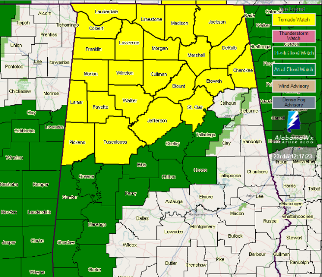
Good News… Tornado Watch Has Been Cancelled
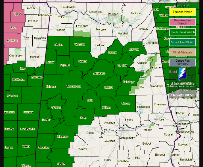
All counties in Central Alabama have been removed from the Tornado Watch as the threat of organized severe weather has come to an end behind the line of storms.
___________________________________________
WATCH COUNTY NOTIFICATION FOR WATCH 365
NATIONAL WEATHER SERVICE BIRMINGHAM AL
407 PM CDT FRI JUN 23 2017
ALC009-073-125-232215-
/O.CAN.KBMX.TO.A.0365.000000T0000Z-170624T0100Z/
THE NATIONAL WEATHER SERVICE HAS CANCELLED TORNADO WATCH 365 FOR
THE FOLLOWING AREAS
IN ALABAMA THIS CANCELS 3 COUNTIES
IN CENTRAL ALABAMA
BLOUNT JEFFERSON
IN WEST CENTRAL ALABAMA
TUSCALOOSA
THIS INCLUDES THE CITIES OF BIRMINGHAM, HOOVER, ONEONTA,
AND TUSCALOOSA.
$$
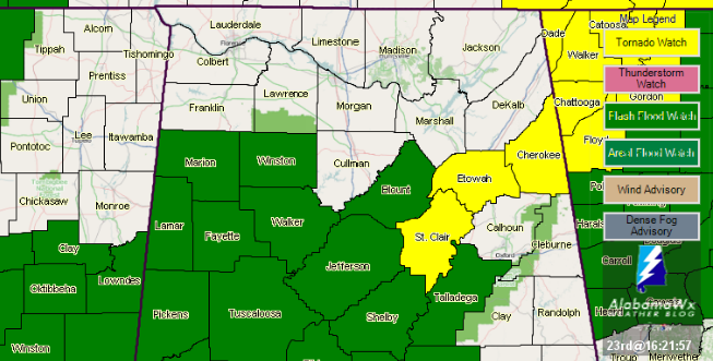
ALC019-055-115-240100-
/O.CON.KBMX.TO.A.0365.000000T0000Z-170624T0100Z/
TORNADO WATCH 365 REMAINS VALID UNTIL 8 PM CDT THIS EVENING FOR
THE FOLLOWING AREAS
IN ALABAMA THIS WATCH INCLUDES 3 COUNTIES
IN CENTRAL ALABAMA
ST. CLAIR
IN NORTHEAST ALABAMA
CHEROKEE ETOWAH
THIS INCLUDES THE CITIES OF CENTRE, GADSDEN, MOODY,
AND PELL CITY.
_______________________________________
WATCH COUNTY NOTIFICATION FOR WATCH 365
NATIONAL WEATHER SERVICE BIRMINGHAM AL
313 PM CDT FRI JUN 23 2017
ALC127-133-232115-
/O.CAN.KBMX.TO.A.0365.000000T0000Z-170624T0100Z/
THE NATIONAL WEATHER SERVICE HAS CANCELLED TORNADO WATCH 365 FOR
THE FOLLOWING AREAS
IN ALABAMA THIS CANCELS 2 COUNTIES
IN CENTRAL ALABAMA
WALKER
IN NORTHWEST ALABAMA
WINSTON
THIS INCLUDES THE CITIES OF HALEYVILLE AND JASPER.
$$
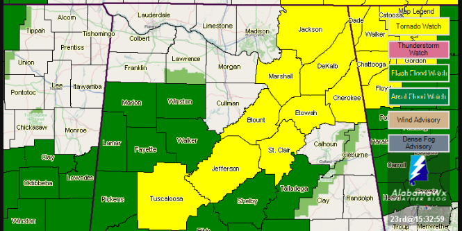
ALC009-019-055-073-115-125-240100-
/O.CON.KBMX.TO.A.0365.000000T0000Z-170624T0100Z/
TORNADO WATCH 365 REMAINS VALID UNTIL 8 PM CDT THIS EVENING FOR
THE FOLLOWING AREAS
IN ALABAMA THIS WATCH INCLUDES 6 COUNTIES
IN CENTRAL ALABAMA
BLOUNT JEFFERSON ST. CLAIR
IN NORTHEAST ALABAMA
CHEROKEE ETOWAH
IN WEST CENTRAL ALABAMA
TUSCALOOSA
THIS INCLUDES THE CITIES OF BIRMINGHAM, CENTRE, GADSDEN, HOOVER,
MOODY, ONEONTA, PELL CITY, AND TUSCALOOSA.
___________________________________________
WATCH COUNTY NOTIFICATION FOR WATCH 365
NATIONAL WEATHER SERVICE BIRMINGHAM AL
228 PM CDT FRI JUN 23 2017
ALC057-075-093-107-232030-
/O.CAN.KBMX.TO.A.0365.000000T0000Z-170624T0100Z/
THE NATIONAL WEATHER SERVICE HAS CANCELLED TORNADO WATCH 365 FOR
THE FOLLOWING AREAS
IN ALABAMA THIS CANCELS 4 COUNTIES
IN NORTHWEST ALABAMA
MARION
IN WEST CENTRAL ALABAMA
FAYETTE LAMAR PICKENS
THIS INCLUDES THE CITIES OF ALICEVILLE, CARROLLTON, FAYETTE,
HAMILTON, SULLIGENT, AND VERNON.
$$
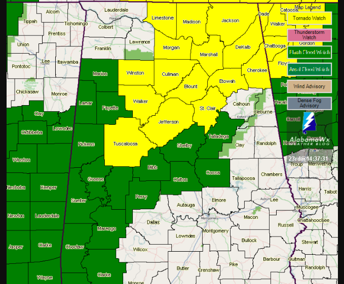
ALC009-019-055-073-115-125-127-133-240100-
/O.CON.KBMX.TO.A.0365.000000T0000Z-170624T0100Z/
TORNADO WATCH 365 REMAINS VALID UNTIL 8 PM CDT THIS EVENING FOR
THE FOLLOWING AREAS
IN ALABAMA THIS WATCH INCLUDES 8 COUNTIES
IN CENTRAL ALABAMA
BLOUNT JEFFERSON ST. CLAIR
WALKER
IN NORTHEAST ALABAMA
CHEROKEE ETOWAH
IN NORTHWEST ALABAMA
WINSTON
IN WEST CENTRAL ALABAMA
TUSCALOOSA
THIS INCLUDES THE CITIES OF BIRMINGHAM, CENTRE, GADSDEN,
HALEYVILLE, HOOVER, JASPER, MOODY, ONEONTA, PELL CITY,
AND TUSCALOOSA.
______________________________________
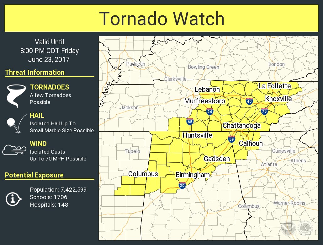
URGENT – IMMEDIATE BROADCAST REQUESTED
Tornado Watch Number 365
NWS Storm Prediction Center Norman OK
1215 PM CDT Fri Jun 23 2017
The NWS Storm Prediction Center has issued a
* Tornado Watch for portions of
Western and Northern Alabama
Northwest Georgia
Eastern Mississippi
Middle and Eastern Tennessee
* Effective this Friday afternoon and evening from 1215 PM until
800 PM CDT.
* Primary threats include…
A few tornadoes possible
Isolated damaging wind gusts to 70 mph possible
SUMMARY…Preceding the east/northeastward-moving remnants of Cindy,
a very air mass and strong low/mid-level winds will support both
organized bowing structures and some line-preceding or embedded
supercells capable of a few tornadoes and locally damaging winds
this afternoon into early evening.
The tornado watch area is approximately along and 80 statute miles
east and west of a line from 45 miles north northeast of Crossville
TN to 20 miles south southwest of Tuscaloosa AL. For a complete
depiction of the watch see the associated watch outline update
(WOUS64 KWNS WOU5).
PRECAUTIONARY/PREPAREDNESS ACTIONS…
REMEMBER…A Tornado Watch means conditions are favorable for
tornadoes and severe thunderstorms in and close to the watch
area. Persons in these areas should be on the lookout for
threatening weather conditions and listen for later statements
and possible warnings.
About the Author (Author Profile)
Scott Martin is an operational meteorologist, professional graphic artist, musician, husband, and father. Not only is Scott a member of the National Weather Association, but he is also the Central Alabama Chapter of the NWA president. Scott is also the co-founder of Racecast Weather, which provides forecasts for many racing series across the USA. He also supplies forecasts for the BassMaster Elite Series events including the BassMaster Classic.Subscribe
If you enjoyed this article, subscribe to receive more just like it.


