

Strong Storms About To Affect Blount, Etowah, St. Clair, & Cherokee Counties
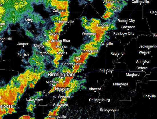
Expect some strong, gusty winds and torrential rainfall if you are in the path of these storms. There is a possibility of this storm spawning a brief spin-up tornado, so stay weather aware.
Special Weather Statement
National Weather Service Birmingham AL
259 PM CDT FRI JUN 23 2017
ALZ017-018-020-026-232100-
Etowah-St. Clair-Blount-Cherokee-
259 PM CDT FRI JUN 23 2017
…A STRONG THUNDERSTORM WILL AFFECT SOUTHEASTERN BLOUNT…ETOWAH…
NORTH CENTRAL ST. CLAIR AND SOUTHWESTERN CHEROKEE COUNTIES…
At 259 PM CDT, a strong thunderstorm was located near Oneonta, moving
northeast at 45 mph.
Winds in excess of 40 mph are possible with this storm.
Locations impacted include…
Gadsden, Rainbow City, Oneonta, Hokes Bluff, Attalla, Glencoe,
Ashville, Sardis City, Steele, Leesburg, Altoona, Walnut Grove, Reece
City, Tabor Road, Cherokee Rock Village, Aurora, Ballplay, Slackland,
Gadsden Mall and Noccalula Falls.
Torrential rainfall is also occurring with this storm, and may cause
localized flooding. Do not drive your vehicle through flooded
roadways.
Category: Archived Warnings
About the Author (Author Profile)
Scott Martin is an operational meteorologist, professional graphic artist, musician, husband, and father. Not only is Scott a member of the National Weather Association, but he is also the Central Alabama Chapter of the NWA president. Scott is also the co-founder of Racecast Weather, which provides forecasts for many racing series across the USA. He also supplies forecasts for the BassMaster Elite Series events including the BassMaster Classic.Subscribe
If you enjoyed this article, subscribe to receive more just like it.


