

Strong Storms Now Affecting The East-Central Parts of Central Alabama
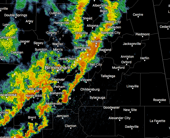
Strong storms are moving into the eastern parts of Central Alabama, and are putting down some impressive rainfall. Please stay weather aware as these storms can produce gusty winds that could knock down some trees with the saturated ground. Also, a brief spin-up tornado is possible.
Special Weather Statement
National Weather Service Birmingham AL
323 PM CDT FRI JUN 23 2017
ALZ017>019-024>027-232130-
Calhoun-Etowah-Jefferson-Shelby-Talladega-St. Clair-Blount-
323 PM CDT FRI JUN 23 2017
…A LINE OF STRONG THUNDERSTORMS WILL AFFECT TALLADEGA…
SOUTHEASTERN BLOUNT…CALHOUN…SHELBY…SOUTHERN ETOWAH…EAST
CENTRAL JEFFERSON AND ST. CLAIR COUNTIES…
At 323 PM CDT, radar indicated strong thunderstorms were located
along a line extending from near Steele to Calera. Movement was
northeast at 40 mph.
Winds in excess of 40 mph are possible with these storms.
Locations impacted include…
Birmingham, Hoover, Gadsden, Vestavia Hills, Alabaster, Anniston,
Pelham, Oxford, Trussville, Talladega, Sylacauga, Pell City,
Jacksonville, Irondale, Leeds, Moody, Calera, Chelsea, Rainbow City
and Montevallo.
Torrential rainfall is also occurring with these storms, and may
cause localized flooding. Do not drive your vehicle through flooded
roadways.
Frequent cloud to ground lightning is occurring with this storm.
Lightning can strike 10 miles away from a thunderstorm. Seek a safe
shelter inside a building or vehicle.
Category: Archived Warnings
About the Author (Author Profile)
Scott Martin is an operational meteorologist, professional graphic artist, musician, husband, and father. Not only is Scott a member of the National Weather Association, but he is also the Central Alabama Chapter of the NWA president. Scott is also the co-founder of Racecast Weather, which provides forecasts for many racing series across the USA. He also supplies forecasts for the BassMaster Elite Series events including the BassMaster Classic.Subscribe
If you enjoyed this article, subscribe to receive more just like it.


