

Storms Starting to Fire: A Little Weather Geekery for Lunch
UPDATE 1116AM
The NWS in Huntsville has issued a significant weather advisory for Jackson County for the storm southwest of Scottsboro. Winds of 50 mph, heavy rain and lightning will accompany the storm.
The storm over southern Lamar County near Millport has intensified. Tops are now approaching 50,000 feet on that storm. It will pass near or just south of Fayette and Belk.
ORIGINAL POST
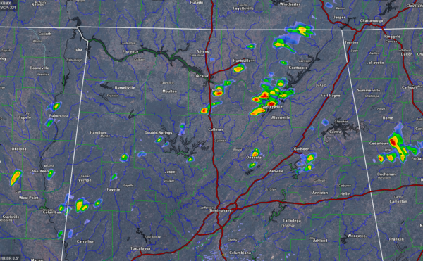
Showers have formed rapidly in the past few minutes over Northeast and are starting to fire from East Central Mississippi into parts of West Central Alabama. Lightning is beginning to show up in the storm near Nauvoo in northern Walker County.
There is already good lightning on the storms in Marshall County and southern Jackson County north of Albertville as well as the storms in Morgan County, southeast of Decatur.
This is a fulfillment of what the mesoscale models have been prophesying this morning, with fairly widespread showers and storms filling areas north and west of I-59 by 1 p.m. These storms should migrate into the I-59 Corridor between 2 and 3 p.m., then slowly go downhill as they advance into drier air further south and southeast.
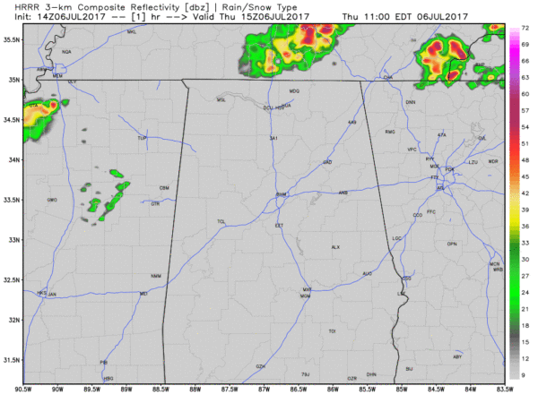
A couple of additional storms could bubble up during the late afternoon and evening across the northern half of Alabama. They should be isolated, but could pack a punch as well.
PARAMETER WATCH
Here is the mean sounding taken for a domain that includes much of North Central Alabama at 1 p.m. from Levi Cowan’s fabulous webiste www.tropical tidbits.com.
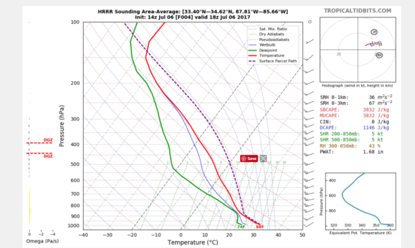
It’s a little bit of weather geekery, but it shows strong instability (CAPE = 3832 j/kg), very low shear (5 knots), no convective inhibition (0 j/kg). a very moist atmosphere (PWAT = 1.68 inches) and a strong downdraft CAPE of 1146 j/kg.
The strong instability should lead to vigorous thunderstorm updrafts. No convective inhibition means the storms should be able to fire with the daytime heating, assisted by numerous outflow boundaries approaching from the northwest.
We are near the convective temperatures already calculated from the morning balloon launch from the NWS Birmingham, which is 87F.
The low shear means the storms will be of the “pulse” variety, meaning they will quickly pulse up, then collapse about as quickly, while other cells pulse up nearby. There is good bit of dry air aloft, as evidenced by the green line on the sounding (dew point) shifting left to create a wide variance with the red line (temperature). That dry air can help downward momentum and create the potential for downbursts. These bursts of air sink rapidly and crash into the ground, spreading out as strong winds that can reach 60 mph or greater and cause damage. The high downdraft CAPE signals that potential.
The high precipitable water values mean that the downpours associated with storms will be be very heavy, perhaps dumping an inch of rain in 30 minutes. That could cause flooding.
We will be watching the storms all afternoon. We will have frequent updates and warnings will of course post to the blog within seconds of their issuance from the National Weather Service.
Category: Alabama's Weather, ALL POSTS
About the Author (Author Profile)
Bill Murray is the President of The Weather Factory. He is the site's official weather historian and a weekend forecaster. He also anchors the site's severe weather coverage. Bill Murray is the proud holder of National Weather Association Digital Seal #0001 @wxhistorianSubscribe
If you enjoyed this article, subscribe to receive more just like it.


