Severe Thunderstorm Warning Expired For Parts Of Dekalb County
…THE SEVERE THUNDERSTORM WARNING FOR EAST CENTRAL DEKALB COUNTY
WILL EXPIRE AT 1230 PM CDT…
The storm which prompted the warning has weakened below severe
limits, and no longer poses an immediate threat to life or property.
Therefore the warning will be allowed to expire. However gusty winds
are still possible with this thunderstorm.
Severe Thunderstorm Warning Continues For Parts Of Dekalb County Until 12:30PM
Jul 6th @ 11:53 am

…A SEVERE THUNDERSTORM WARNING REMAINS IN EFFECT UNTIL 1230 PM CDT FOR EAST CENTRAL DEKALB COUNTY… At 1213 PM CDT, a severe thunderstorm was located near Henagar, or 7 miles north of Fort Payne, moving east at 30 mph. Damaging winds have been reported in the Fyffe area.
HAZARD…60 mph wind gusts.
SOURCE…Radar indicated.
IMPACT…Expect damage to roofs, siding, and trees. Locations impacted include… Fort Payne, Rainsville, Henagar, Sylvania, Fyffe, Powell, Valley Head, Hammondville, Mentone and Pine Ridge.
Severe Thunderstorm Warning Issued For Parts Of Dekalb County Until 12:30PM
Jul 6th @ 11:53 am
We have our first warning of the day for an impressive storm near Rainsville in DeKalb County. It will be approacing Fort Payne.
Tops are over 50,000 feet and rainfall rates have been approaching one inch per hour. Radar indicates nearly 60 dbz of reflectivity at 28,000 feet meaning there is a large mass of precipitation at a very high altitude. All that has to come down at some point, and when it does, it could produce a significant downburst. Damaging winds could result.

The National Weather Service in Huntsville Alabama has issued a
* Severe Thunderstorm Warning for…
Central DeKalb County in northeastern Alabama…
* Until 1230 PM CDT
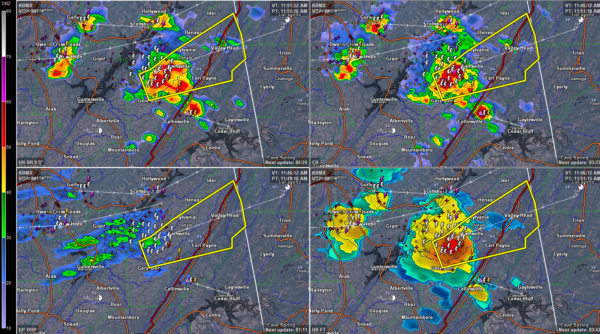
* At 1152 AM CDT, a severe thunderstorm was located over Rainsville, moving east at 30 mph.
HAZARD…60 mph wind gusts.
SOURCE…Radar indicated.
IMPACT…Expect damage to roofs, siding, and trees.
* Locations impacted include…
Fort Payne, Rainsville, Henagar, Sylvania, Fyffe, Powell, Geraldine, Valley Head, Hammondville and Mentone.
Category: ALL POSTS, Archived Warnings
About the Author (Author Profile)
Subscribe
If you enjoyed this article, subscribe to receive more just like it.


