

Flooding Is A Real Problem Across Parts of Jefferson County
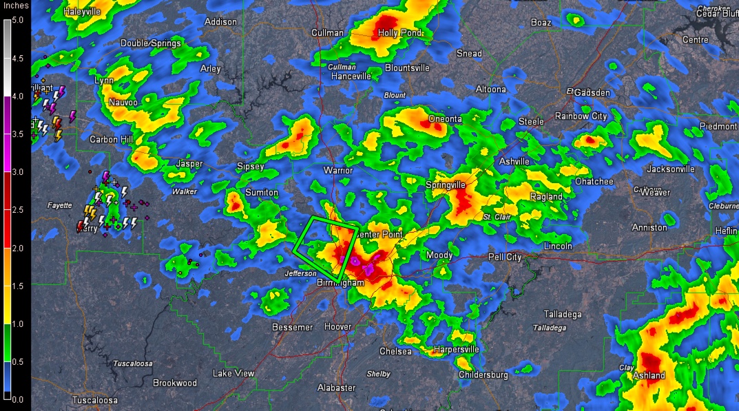
Doppler radar estimates of rainfall across the area this afternoon.
Flooding has been the problem this afternoon across Central Alabama.
There is major flooding in parts of the Birmingham Metro area and an Areal Flood WArning is in effect until 8:15 p.m. CDT for the northern and eastern parts of the County including places like Gardendale, Fultondale, Trussville, Mountain Brook and Homewood.
There is a flood warning for Village Creek in northwestern Birmingham, near Avenue W. Flood stage of 10 feet will be achieved.
There is tremendous flooding along Tallapoosa Street and AL-79 from I-20/59 northward through Tarrant City. Avoid this area. Water rescues had to be performed.
3.63 inches of rain had fallen through 5 p.m. at the BHM Airport. This is a new record for the date. An amazing 2.93 inches of that fell in one hour.
Water is high in parts of Mountain Brook, along Shades Creek. Flash flooding was reported earlier at the Mountain Brok Country Club.
Heavy thunderstorms continue this afternoon across parts of Northwest Alabama, over Colbert, Marion, Franklin, Lamar and Fayette Counties. Heavy rain, lightning, and gusty winds will be the threats. A child was injured by lightning near Liberty Park this afternoon.
Storms should intensify from Montevallo to Clanton to Alex City as an outflow boundary from the earlier storms fires up convection in those areas.
Elsewhere, the rain is light to moderate now as the atmosphere is stable in the rain cooled area.
Category: Alabama's Weather, ALL POSTS
About the Author (Author Profile)
Bill Murray is the President of The Weather Factory. He is the site's official weather historian and a weekend forecaster. He also anchors the site's severe weather coverage. Bill Murray is the proud holder of National Weather Association Digital Seal #0001 @wxhistorianSubscribe
If you enjoyed this article, subscribe to receive more just like it.


