

Wet/Stormy At Times Through Friday
RADAR CHECK: Heaviest rain at mid-afternoon is over West Alabama… showers and storms are moving east…
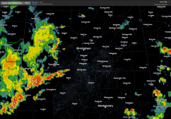
The sky is mostly cloudy across the northern half of the state with temperatures in the 80s. We will maintain a good chance of occasional showers and storms through tonight with potential for heavy rain in spots in this very moist environment.
We do note SPC has a “marginal risk” of severe storms defined through tonight for parts of North and Central Alabama; heavier storms could produce small hail and gusty winds.
REST OF THE WEEK: With a broad upper trough, copious amounts of moisture, and an unstable airmass, our weather will remain wet and stormy at times through Friday. Showers and storms are a good possibly each day; the rain won’t be continuous, but it will be heavy at times. I would not be surprised to see some flash flooding issues before the week is over… parts of Central Mississippi are already under a flash flood watch.
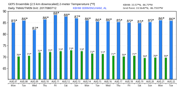
Daytime temperatures will remain below average with highs in the mid 80s most days.
THE ALABAMA WEEKEND: Not much change. A very moist, unstable airmass will cover Alabama both days with scattered to numerous showers and storms. There will be some breaks in the rain, and the sun could pop out at times, but be ready for showers and storms at just about any our Saturday and Sunday. Highs hold in the 80s.
NEXT WEEK: The unsettled pattern continues, at least for the first half of the week, with a good chance of showers and storms. No sign of any 90 degree heat through mid-month, which is pretty remarkable for August in Alabama.
FRANKLIN NEARING THE YUCATAN PENINSULA: Tropical Storm Franklin is packing sustained winds of 60 mph, and will move into Mexico’s Yucatan Peninsula tonight. It will then emerge into the Bay of Campeche, and make the a second landfall on the Mexican coast, well south of Brownsville, Texas, on Thursday. No impact on the northern Gulf of Mexico, or the Alabama/Northwest Florida Gulf Coasts.
The wave over the Central Atlantic is struggling with dry air and shear, and there is a pretty decent chance this one doesn’t develop. The rest of the Atlantic basin is quiet.
BEACH FORECAST: Click here to see the AlabamaWx Beach Forecast Center page. The Beach Forecast is partially underwritten by the support of Brett/Robinson Vacation Rentals in Gulf Shores and Orange Beach. Click here to see Brett/Robinson’s Own Your Summer specials now!
WEATHER BRAINS: Don’t forget you can listen to our weekly 90 minute netcast anytime on the web, or on iTunes. This is the show all about weather featuring many familiar voices, including our meteorologists here at ABC 33/40. We will produce this week’s show tonight at 8:30p CT… you can watch it live here.
CONNECT: You can find me on all of the major social networks…
Facebook
Twitter
Google Plus
Instagram
Pinterest
Snapchat: spannwx
Look for the next Weather Xtreme video here by 7:00 a.m. tomorrow…
Category: Alabama's Weather, ALL POSTS, Weather Xtreme Videos
About the Author (Author Profile)
James Spann is one of the most recognized and trusted television meteorologists in the industry. He holds the AMS CCM designation and television seals from the AMS and NWA. He is a past winner of the Broadcast Meteorologist of the Year from both professional organizations.Subscribe
If you enjoyed this article, subscribe to receive more just like it.


