

Flash Flood Watch Continues For Parts Of Central Alabama
URGENT – IMMEDIATE BROADCAST REQUESTED
Flood Watch
National Weather Service Birmingham AL
400 AM CDT Wed Aug 9 2017
Flash flooding across portions of Central Alabama will remain possible through today…
Most areas are experiencing a lull in the rain activity during the pre dawn hours. Showers and a few thunderstorms are expected to redevelop and the threat of localized heavy rainfall remains possible once again today.
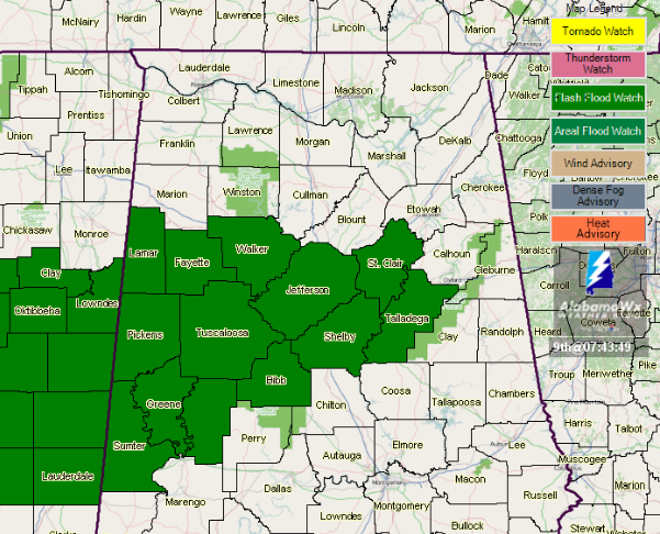
The Flash Flood Watch has been extended for
* Portions of Central Alabama, including the following areas, Bibb, Fayette, Greene, Hale, Jefferson, Lamar, Pickens, Shelby, St. Clair, Sumter, Talladega, Tuscaloosa and Walker counties.
* Through 7 PM CDT this evening.
* Saturated soils from previous rains and some flooding that occurred on Tuesday as well as additional isolated amounts of 2 plus inches of rain are possible today over the watch area. This potential for heavy rain may result in isolated areas of flash flooding across portions of Central Alabama.
PRECAUTIONARY/PREPAREDNESS ACTIONS…
A Flash Flood Watch means that conditions may develop that lead to flash flooding. Flash flooding is a very dangerous situation.
You should monitor later forecasts and be prepared to take action should Flash Flood Warnings be issued.
___________________________________________________________
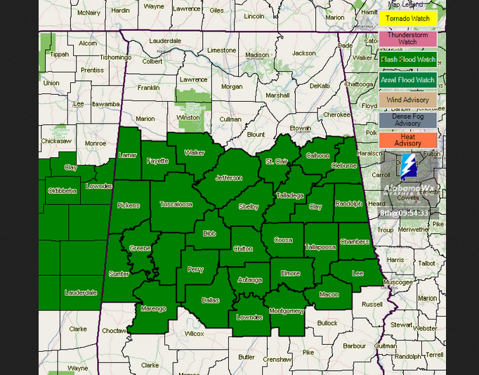
…FLASH FLOOD WATCH IN EFFECT THROUGH WEDNESDAY AFTERNOON…
Flash Flooding Across Central Alabama Possible through Wednesday
The National Weather Service in Birmingham has issued a Flash Flood Watch through Wednesday afternoon for portions of central Alabama including the following areas:
Autauga, Bibb, Chilton, Coosa, Dallas, Elmore, Jefferson, Lowndes, Montgomery, Perry, Shelby, St. Clair, Talladega, Walker, Calhoun, Chambers, Clay, Cleburne, Lee, Macon, Randolph, Tallapoosa, Fayette, Greene, Hale, Lamar, Marengo, Pickens, Sumter, and Tuscaloosa.
Ongoing isolated areas of flooding as well as an additional 2 to 3 inches of rain through Wednesday over the watch area. This heavy rain may result in isolated areas of flash flooding across portions of Central Alabama.
A Flash Flood Watch means that conditions may develop that lead to flash flooding. Flash flooding is a very dangerous situation. You should monitor later forecasts and be prepared to take action should Flash Flood Warnings be issued.
About the Author (Author Profile)
Scott Martin is an operational meteorologist, professional graphic artist, musician, husband, and father. Not only is Scott a member of the National Weather Association, but he is also the Central Alabama Chapter of the NWA president. Scott is also the co-founder of Racecast Weather, which provides forecasts for many racing series across the USA. He also supplies forecasts for the BassMaster Elite Series events including the BassMaster Classic.Subscribe
If you enjoyed this article, subscribe to receive more just like it.


