Summer Rain Continues
FLASH FLOOD WATCH: NWS Birmingham continues a flash flood watch for Central Alabama through at least tomorrow as a very wet weather pattern continues…
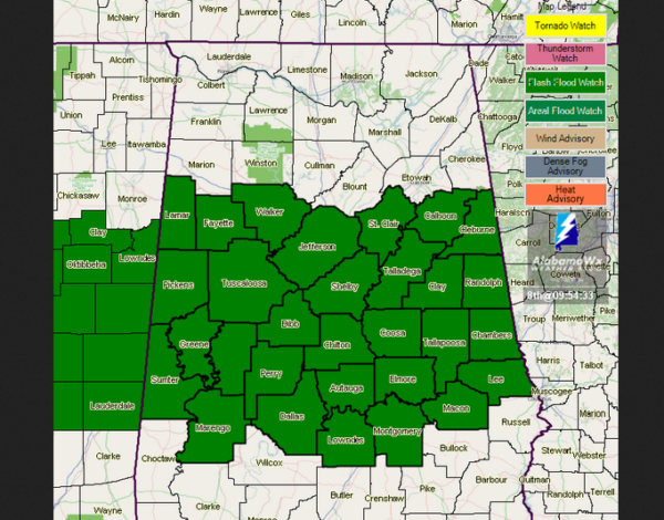
A large area of rain, with a few embedded thunderstorms, continues to move across North/Central Alabama this afternoon; heaviest rain as I write this at 3:15p CT was over Bibb and Perry Counties. Rain will continue at times tonight.
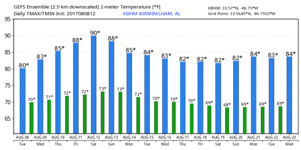
Birmingham reports 75 degrees at 3:00… that is almost 20 degrees below average for August 8.
REST OF THE WEEK: A surface front just to the north, near the Tennessee border, will drift northward and dissipate, leaving Alabama in a deep layer of tropical moisture. Occasional showers and storms are likely tomorrow through Friday, with potential for heavy rain at times. Of course, there will be breaks in the rain, and a few peeks of sun are possible. But the overall pattern remains wet. Additional rain amounts of 1-3 inches are likely, and some flooding issues are very possible.
Daytime temperatures will remain well below average for mid-August with highs only in the 80s.
THE ALABAMA WEEKEND: No real change. The sky will be generally cloudy Saturday and Sunday with scattered to numerous showers and thunderstorms both days; highs will hold in the 80s.
NEXT WEEK: The latest GFS run continues the idea of bringing drier air down into the northern half of Alabama Tuesday, suggesting a chance to dry out during the middle of the week. See the Weather Xtreme video for maps, graphics, and more details.
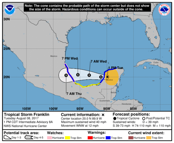
FRANKLIN: Tropical Storm Franklin is moving back over water this afternoon; it will cross the Bay of Campeche tonight and tomorrow, with the final landfall on the Mexican coast well south of Brownsville, Texas late tomorrow night or early Thursday morning. The latest NHC forecast suggests the system will remain below hurricane strength.
INVEST 99L: The disturbance in the Atlantic between the Lesser Antilles and the coast of Africa is still struggling due to dry air and shear; if anything survives models suggest it will recurve off the East Coast of the U.S.
There are no tropical systems threatening the northern Gulf of Mexico for at least the next 7 days.
BEACH FORECAST: Click here to see the AlabamaWx Beach Forecast Center page. The Beach Forecast is partially underwritten by the support of Brett/Robinson Vacation Rentals in Gulf Shores and Orange Beach. Click here to see Brett/Robinson’s Own Your Summer specials now!
WEATHER BRAINS: Don’t forget you can listen to our weekly 90 minute netcast anytime on the web, or on iTunes. This is the show all about weather featuring many familiar voices, including our meteorologists here at ABC 33/40.
CONNECT: You can find me on all of the major social networks…
Facebook
Twitter
Google Plus
Instagram
Pinterest
Snapchat: spannwx
I enjoyed seeing the big crowd today at Eden Westside Baptist Church in Pell City… look for the next Weather Xtreme video here by 7:00 a.m. tomorrow…
Category: Alabama's Weather, ALL POSTS, Weather Xtreme Videos
About the Author (Author Profile)
James Spann is one of the most recognized and trusted television meteorologists in the industry. He holds the AMS CCM designation and television seals from the AMS and NWA. He is a past winner of the Broadcast Meteorologist of the Year from both professional organizations.Subscribe
If you enjoyed this article, subscribe to receive more just like it.


