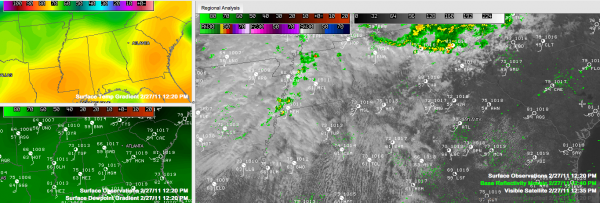
Clouds Breaking Up, Temperatures Climbing
Click the image above for a closer look.
Clouds were breaking up across Central Alabama on this Sunday, giving way to increasing sunshine as evidenced by the visible satellite image on the right side of this graphic. Some places, like Montgomery have had more sunshine, and have warmed faster. It was already 79F at noon in Alabama’s Capital City. It was 78F in Tuscaloosa and 72F at Birmingham Meanwhile, it was just 66F at Gadsden. Drill down to see more station observations from noon superimposed on the satellite image. We could have several 80F readings across Central Alabama, with most spots topping out in the middle 70s.
The top left panel of the graphic shows surface temperatures. The lower left shows dewpoints.
Winds were beginning to increase across Central Alabama as a 996 millibar surface low southeast of Denver begins to move out onto the Plains. It will continue to be breezy overnight and windy tomorrow.
Overnight lows tonight will only fall into the middle 60s. There could be a few showers and even a storm tonight, mainly after midnight, but the greatest chance of rain and thunderstorms will begin around daybreak over Northwest Alabama, progressing southeastward through the morning hours, and into areas south and southeast of Birmingham after lunch time.
Scroll down for a closer look at the severe weather threat for Monday.
Category: Alabama's Weather, Severe Weather


