Severe Weather
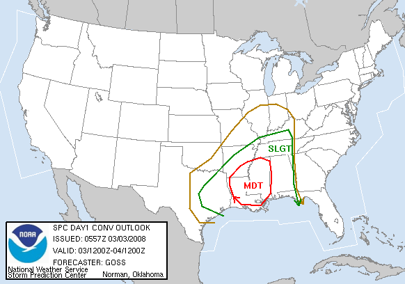
SPC has issued its severe weather outlook for Monday. To read it, click here.
00 UTC models have changed very little overall. The low may be a little stronger, and the dewpoints over Alabama a little higher, but the basic idea is still the same. An upper low will approach Alabama today. Out ahead of it warm, moist air will flow in from the Gulf of Mexico on strong southerly winds. Supercell storms with some tornadoes will likely develop in Mississippi during the afternoon, and some of these storms may move into Alabama by evening. A squall line will then move through, reaching BHM between 2 am and 6 am. There are some things we feel confident about with this event, and others that are still questionable. Some observations.
1. There will be very strong low-level winds. Winds will pick up out of the south tomorrow, bringing in warm, moist air. Winds may gust 20-30 mph during the day. By tomorrow evening, as the low-level jet moves in, winds at 850 mb (about 4,000 feet, shown in map below) will increase to near 65 mph at BHM. Even if we only get a squall line late tonight, these winds can be transported to the surface by a thunderstorm and cause serious wind damage.
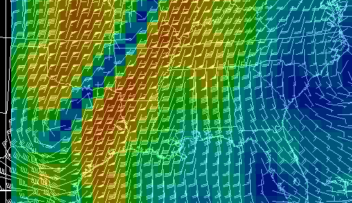
NAM 850 mb winds, 12 UTC Mon – 12 UTC Tue
2. It will be warm. Temperatures could easily reach 80 today with some sunshine, and the models may be underestimating that. It reached 75 at BHM Sunday, and low-level temperatures will be 4 or 5 degrees warmer today.
3. The instability is still questionable, at least as far as a tornado outbreak in Alabama. Models now show dewpoints in the lower 60s all the way to Huntsville. But, the instability depends on low-level warm, moist air, and upper-level cool air. If temperatures hold in the 70s tomorrow evening, which is possible with wind, and upper-level temperatures stay where they are now, it will be unstable enough for a few tornadoes to move into Alabama this evening. Models show warming aloft ahead of the big upper-level low. This is odd for a dynamic weather system, but possible given the circular nature of the low coming in. Even still, a surface temperature/dewpoint of 70/63, which seems quite reasonable for BHM in the evening, would be unstable. So, there a lot of variables that are hard to know right now with such a dynamic system, down to how much it cools off in the evening.
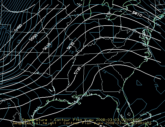
500 mb heights and temperature
4. The dewpoint is a factor. The air in the Gulf of Mexico is still adjusting from the Arctic front last week, and dewpoints even at the buoy way south of Panama City are only in the lower 60s. But, they are going up.

5. Wind shear will be high. 0-1 km storm-relative helicity will be over 300 m2/s2. Any discrete storms that form ahead of the main line may rotate, and some tornadoes are possible. The greatest risk for these storms is in the areas of greatest instability, over Mississippi and Louisiana. However, if the air stays unstable here, those storms may move into Alabama in the evening, with a tornado threat.
No matter what, we will see a line of intense storms with the possibility for large hail and damaging straight line winds, coming through after midnight. There could be some tornadoes along the line. If the air is unstable enough, we could see storms out ahead of the line, which would be more dangerous.
Watch the weather today, and don’t go to sleep tonight without a NOAA weather radio!
Category: Uncategorized
About the Author (Author Profile)
Subscribe
If you enjoyed this article, subscribe to receive more just like it.


