Five Years Ago Tonight: The Greensburg, KS EF5 Tornado
On the morning of May 4, 2007, it was evident that an outbreak of severe weather was imminent across the Plains states of the U.S. The Storm Prediction center realized the threat and posted a Moderate Risk outlook for the region from the Texas Panhandle and western Oklahoma into Kansas and Nebraska. A powerful upper level trough was over the West with strong low pressure over Colorado with very moist Gulf of Mexico air being drawn northward. Instability values were sky high, with CAPE values running as high as 5,500 j/kg! An approaching dry line triggered supercell thunderstorms during the evening from north Texas to southwestern Kansas. With plenty of wind shear, the storms quickly became severe.
One tremendous supercell storm formed about 5 p.m. in the Texas Panhandle and moved northeast. CAPE values were around 5,200 j/kg over Southwest Kanasas, and the 0-2 km helicity was 240 m2s2. This made the EHI 7.8! Readings over 2 are nearly always associated with big tornadoes. The storm that this environment produced would bear twenty tornadoes during its long life, including four massive tornadoes that were on the ground continuously for three hours.
The largest tornado in the family touched down in Comanche County, Kansas at 9:03 p.m. and crossed into Kiowa County a short time later. The first tornado warning for Comanche County was issued at 8:13 p.m. The first tornado warning for Kiowa County was issued at 8:55 p.m. Another warning was issued at 9:19 p.m. that specifically mentioned Greensburg and stated that it was a confirmed tornado. A call was placed to Kiowa County. Sirens started sounding.
Here is the NOAA Weather Radio message for that warning…
At 9:28, a powerful severe weather statement was issued and Kiowa County was called for the second time. At 9:37 p.m., spotters said the large and dangerous tornado was just five miles south of Greensburg. Meteorologist Mike Umscheid pulled the trigger on a chilling Tornado Emergency Message.
SEVERE WEATHER STATEMENT
NATIONAL WEATHER SERVICE DODGE CITY KS
941 PM CDT FRI MAY 4 2007
KSC097-050300-
/O.CON.KDDC.TO.W.0025.000000T0000Z-070505T0300Z/
KIOWA KS-
941 PM CDT FRI MAY 4 2007
A TORNADO WARNING REMAINS IN EFFECT UNTIL 1000 PM CDT FOR CENTRAL
KIOWA COUNTY
A TORNADO EMERGENCY FOR GREENSBURG.
AT 937 PM CDT…NATIONAL WEATHER SERVICE METEOROLOGISTS AND STORM
SPOTTERS WERE TRACKING A LARGE AND EXTREMELY DANGEROUS TORNADO. THIS
TORNADO WAS LOCATED 5 MILES SOUTH OF GREENSBURG…MOVING NORTH AT 20
MPH.
A VIOLENT TORNADO WAS ON A DIRECT PATH FOR PORTIONS OF GREENSBURG…
ESPECIALLY THE EASTERN PORTIONS OF TOWN. TAKE IMMEDIATE TORNADO
PRECATIONS…THIS IS AN EMERGENCY SITUATION FOR GREENSBURG!!
A TORNADO WATCH REMAINS IN EFFECT UNTIL 200 AM CDT SATURDAY MORNING
FOR SOUTHWESTERN KANSAS.
LAT…LON 3749 9936 3745 9929 3760 9901 3764 9936
$$
UMSCHEID
We were monitoring the storm right here in Birmingham. I posted several items on our blog before it happened. Here is a link to one of the messages…
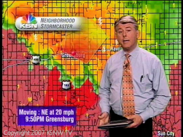
This is the radar from minutes before the horrible storm tore apart Greensburg.

The massive tornado entered the south side of the town of Greensburg at 9:45 p.m. It would plow directly through the heart of the town and it’s tree lined streets. It took several minutes for the giant lawnmower of a storm to roar through Greensburg, destroying ninety five percent of the town. When it was all over, virtually nothing was left standing in the 1.7 mile wide path.
The Greensburg tornado was the first to be rated as an EF5 on the new enhanced Fujita scale was implemented and the first tornado rated at the top of the scale since the Oklahoma City tornado in May 1999. Winds were estimated at 205 mph.
The warnings from the NWS, dissemination from the media and coordination with emergency management were superb and sirens sounded twenty minutes before the twister struck. Countless lives were spared by the advance warnings, but still eleven people died in the horrific destruction, some in basements. The disaster presented town officials and residents with a unique opportunity to rebuild, and leaders are choosing to do it in a green manner using environmentally friendly practices.
Here is a link to the NWS Dodge City’s web page on the tornado:
https://www.crh.noaa.gov/images/ddc/News/Greensburg/Greensburg_1year_later.pdf
Meteorologist Mike Umscheid was the forecaster that issued the warnings…he has an excellent presentation on the storm…be advised it is a 27 mb download…
https://www.crh.noaa.gov/images/ddc/News/Greensburg/GreensburgPresentation_web_Umscheid.ppt
Category: Met 101/Weather History


Comments (11)
Trackback URL | Comments RSS Feed
Sites That Link to this Post