

Monday’s Severe Weather Threat
The most recent Day 2 Convective Outlook shows much of Alabama has been outlined in the threat for severe weather for Monday. An intensifying area of low pressure over Texas this afternoon will continue to move across the Mississippi River Valley tonight and will be in the Ohio River Valley by tomorrow morning. The low will be tracking into Indiana and Ohio through the day tomorrow. The low will be swinging a cold front across the Southeast during the time and will be the focal for strong to severe thunderstorms tomorrow.
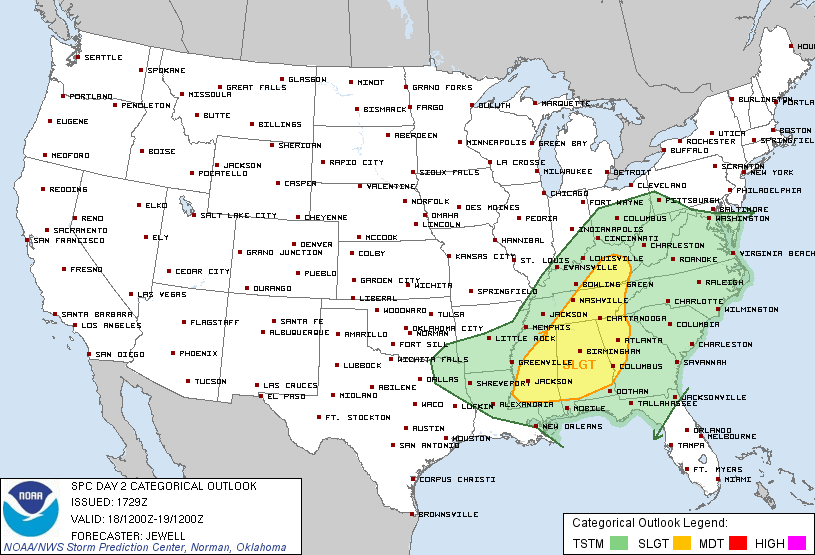
For widespread, organized severe weather events that impact many locations, our best set up is for a low pressure to be in Arkansas or Northern Mississippi. When this happens, veering winds will usually enhance the atmosphere and increase the threat for tornadoes. This low pressure will be much farther north, either in northern Kentucky or southern Illinois. Low pressures tend to move along gradients and there is a significant temperature gradient in the Ohio River Valley. Temperatures in the 70s and 80s in the Southeast today verses temperatures in the 30s and 40s north of the stalled frontal boundary. So with this in mind, that means the greater dynamics will be to our north. However, the very warm air and increasing dew points/moisture across the region, mean the greater instabilities will be in place over us. The front will be providing uplift and thunderstorms will develop. Some will be strong and severe weather is possible in some locations tomorrow. The main threats will be damaging winds and some hail will be possible as well.
Here is what we can expect across Central Alabama tomorrow. Starting the day off, don’t be surprise if there are ongoing showers and thunderstorms across Northern Mississippi and Alabama. Some of the storms could be strong to severe with the greatest threat being damaging winds, as dynamics will be interacting with the unstable atmosphere in place. As the low pressure continues to lift northeastward, the main forcing dynamics will begin moving away from the state. The low will send a front through the area and this is what we will have to watch heading into the afternoon and evening.
As we head into the afternoon and evening. The front will be moving in allowing for additional thunderstorms to develop. Daytime heating will allow for the atmosphere to destabilize and instabilities should increase in much of the area throughout the day. This additional convection could include more widespread strong to severe thunderstorms. Damaging winds and large hail will be the main threat from these storms. Very large hail could be possible with hail stones greater than two inches in diameter possible. There could be a chance for some isolated tornadoes tomorrow as well. The best shear and dynamics across the state later in the day should be across our southern counties. No matter what the case, tomorrow looks to be a fairly active weather day across the state. Make sure you pay carful attention to the changing weather conditions tomorrow.
Category: Alabama's Weather, Severe Weather
About the Author (Author Profile)
Macon, Georgia Television Chief Meteorologist, Birmingham native, and long time Contributor on AlabamaWX. Stormchaser. I did not choose Weather, it chose Me. College Football Fanatic. @Ryan_StinnetSubscribe
If you enjoyed this article, subscribe to receive more just like it.


