

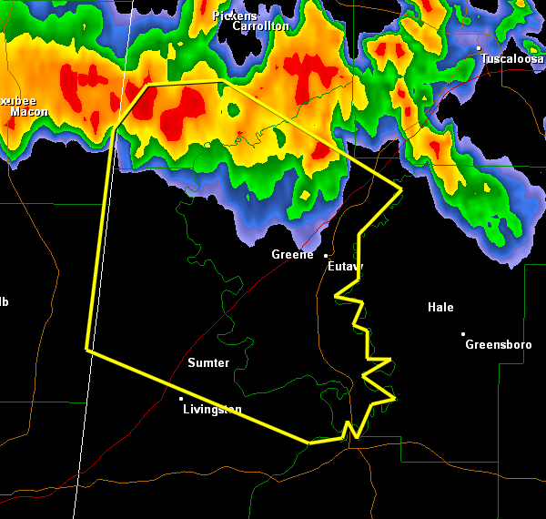
Severe Thunderstorm Warning Greene/Pickens/Sumter

UPDATE: A very intense velocity gradient and strong inflow are associated with these storms and some bowing segments are developing. Very intense winds are possible with these bowing segments, winds could be upwards of 70 mph. This is a very dangerous storm as lightning output as been over 300 strikes in 5 minutes.
A line of strong thunderstorms continues to drop south across West Alabama this evening. These storms are south of Highway 82 and will be impacting area around Eutaw, Boligee, Aliceville, Epes, Geiger, Gainesville and Forkland. Portions of Highways 11 and 43 as well as Interstate 20/59 could see large hail and damaging winds.
THE NATIONAL WEATHER SERVICE IN BIRMINGHAM HAS ISSUED A
* SEVERE THUNDERSTORM WARNING FOR…
GREENE COUNTY IN WEST CENTRAL ALABAMA…
SOUTHWESTERN PICKENS COUNTY IN WEST CENTRAL ALABAMA…
NORTHERN SUMTER COUNTY IN WEST CENTRAL ALABAMA…
* UNTIL 730 PM CDT
* AT 636 PM CDT…THE NATIONAL WEATHER SERVICE INDICATED A SEVERE
THUNDERSTORM CAPABLE OF PRODUCING QUARTER SIZE HAIL…AND
DESTRUCTIVE WINDS IN EXCESS OF 70 MPH. THIS STORM WAS LOCATED NEAR
PANOLA…OR 10 MILES SOUTHWEST OF ALICEVILLE…AND MOVING SOUTHEAST
AT 35 MPH.
* LOCATIONS IMPACTED INCLUDE…
EUTAW…PANOLA…NEW WEST GREENE…EMELLE…WEST GREENE…MANTUA…
GAINESVILLE AND UNION.
THIS INCLUDES…
INTERSTATE 20 EXIT NUMBERS 17 THROUGH 52…
PRECAUTIONARY/PREPAREDNESS ACTIONS…
FOR YOUR PROTECTION…MOVE TO AN INTERIOR ROOM ON THE LOWEST FLOOR OF
YOUR HOME OR BUSINESS.
Category: Alabama's Weather, Severe Weather
About the Author (Author Profile)
Subscribe
If you enjoyed this article, subscribe to receive more just like it.


