

Some Snow Sunday Night, Then Bitterly Cold
An all new edition of the ABC 33/40 Weather Xtreme video is available in the player on the right sidebar of the blog. You can subscribe to the Weather Xtreme video on iTunes by clicking here.
BRIEF WEEKEND WARM-UP: As expected, we have struggled to reach the mid 30s across North/Central Alabama today despite a sunny sky. Tonight will be cold again, and by early tomorrow morning will be in the 20 to 24 degree range.
The good news is that we warm into the upper 40s tomorrow afternoon with a sunny sky. Then, clouds return tomorrow night, and showers will move into Alabama Sunday ahead of the Arctic front. We will see a high in the mid to upper 50s Sunday… it will be our warmest day out of the next seven. Rain on Sunday should be fairly light, generally under 1/2 inch.
SNOW, THEN COLD: Let’s take it one period at a time….
SUNDAY NIGHT SNOW: As bitterly cold air rushes into Alabama (the coldest air in a decade), the rain will change to snow. The 12Z GFS model is a little slower with the cold air, and it now looks like the main window for snow will come from 6:00 p.m. Sunday through 3:00 a.m. Monday. We are now going to forecast about 1/2 inch of snow for that part of Alabama along and north of I-20, or along and north of a line from Tuscaloosa to Birmingham to Anniston. But, south of I-20, there could also be some light accumulation or a dusting perhaps as far south as Demopolis, Clanton, Ashland, and Roanoke.
This is not a major snow event, and for some there won’t be enough to measure, but it also could be enough in spots for icy travel problems Sunday night into Monday morning.
LONG DURATION COLD BLAST: We expect to be below freezing for about 62 consecutive hours from Sunday evening until midday Wednesday.
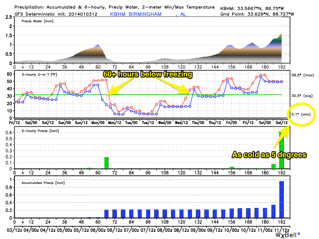
BRUTAL COLD MONDAY: We will be in the 10-13 degree range by early Monday morning, with a north wind of 15-25 mph, creating a wind chill index as low as ten below zero. We stay below freezing all day, and some of the latest guidance hints we won’t even get out of the teens. And, the wind chill index will stay below zero much of the day.
The last time we had a high under 25 degrees in Birmingham was February 4, 1996. We will forecast a high near 20 degrees Monday.
TUESDAY: We will now forecast a low between 5 and 10 degrees at daybreak Tuesday. This will be the coldest morning for us since January 24, 2003 when our low was 7 degrees. At least the wind will be calmer. Tuesday will be sunny, but the high will be in the 20s, and we stay below freezing.
WEDNESDAY: Another bitterly cold morning with temperatures in the 10 to 15 degree range at daybreak. Then, we finally rise above freezing by Wednesday afternoon with a high in the low 40s along with a sunny sky.
SCHOOL DELAYS: Many Alabama schools are delaying their openings next week… see the ABC 33/40 site for a list.
PLANNING: No need for the stupid “cold weather tips” but I would recommend checking on elderly people that might not have an adequate source of heat, and don’t forget to bring in the dogs and cats.
THURSDAY/FRIDAY: The 12Z GFS has backed off of the idea of ice over North Georgia and Northeast Alabama Thursday, so there is little confidence in a solution for these two days at this point. See the Weather Xtreme video for the maps, graphics, and details.
WEATHER BRAINS: Don’t forget you can listen to our weekly 90 minute netcast anytime on the web, or on iTunes. This is the show all about weather featuring many familiar voices, including our meteorologists here at ABC 33/40.
CONNECT: You can find me on all of the major social networks…
Facebook
Twitter
Google Plus
Instagram
Brian Peters will have the video updates here tomorrow and Sunday, and of course the blog will have frequent updates over the weekend as well. My next Weather Xtreme video will be posted bright and early Monday morning by 7:00 a.m. Enjoy the weekend!
Category: Alabama's Weather
About the Author (Author Profile)
James Spann is one of the most recognized and trusted television meteorologists in the industry. He holds the AMS CCM designation and television seals from the AMS and NWA. He is a past winner of the Broadcast Meteorologist of the Year from both professional organizations.Subscribe
If you enjoyed this article, subscribe to receive more just like it.


