

Messy Winter Storm Ahead
An all new edition of the ABC 33/40 Weather Xtreme video is available in the player on the right sidebar of the blog. You can subscribe to the Weather Xtreme video on iTunes by clicking here.
COMPLEX WINTER FORECAST: A challenging forecast for the northern half of Alabama through Wednesday. We have two distinct waves to deal with, so let’s take them one at a time. Concerning the first wave…
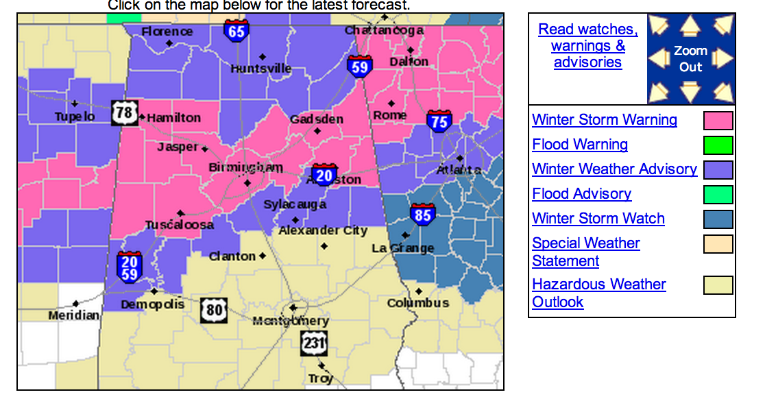
WINTER STORM WARNING: The NWS in Birmingham has issued a winter storm warning for counties generally along and north of I-20 within their County Warning Area (CWA)….
New model guidance confirms potential for snow and ice in this region.
Note the NWS has issued a “winter weather advisory” just below I-20 for Sumter, Greene, Hale, Bibb, Shelby, Talladega, Clay, and Randolph Counties.
Be sure and watch the afternoon Weather Xtreme video for the maps, graphics, and other details.
TIMING: We do not expect any travel problems before 10:00 tonight, and the issues really begin after midnight as a large “wintry mix” moves into Alabama from the west. Bridges, overpasses, and some black top roads will be icy and dangerous through late tomorrow morning. Some slow improvement is possible tomorrow afternoon, but not guaranteed.
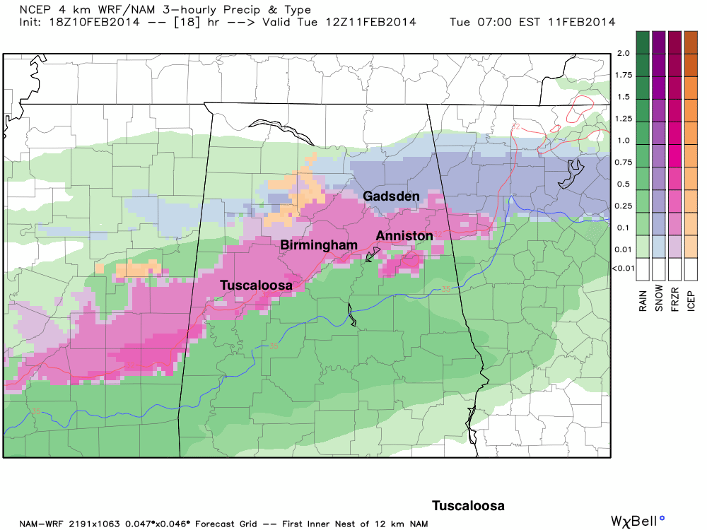
AMOUNTS: Ice accumulation to 1/4″ is possible along I-20 (Tuscaloosa to Birmingham to Anniston). Snow amounts of 1-2 inches possible near U.S. 278 (Hamilton to Cullman to Gadsden). A few spots might see three inches. A mix of sleet, freezing rain, and snow in between those two highways.
IMPACT: Bridges and overpasses will become icy and dangerous after midnight tonight and tomorrow morning. Some black top roads will become snow/ice covered as well. Travel is discouraged after midnight tonight and tomorrow morning.
Ice accumulation could be high enough along I-20 for scattered power outages due to tree limbs and branches falling from the weight of the accumulated ice.
FORECAST CONFIDENCE: There is high confidence in the overall storm system, however there will be a sharp cut-off somewhere around I-20 with a cold rain to the south, and ice and snow to the north. Trying to define this exact line is almost impossible, and we must remember that snow and ice accumulation won’t follow county lines, or lines drawn on weather maps.
ROUND TWO! A vigorous wave aloft will spin up a surface low in the Gulf of Mexico tomorrow night, and another wave of precipitation will move into Alabama tomorrow night and Wednesday. This second wave will bring a chance of more snow and ice to parts of Alabama.
The complicating factor in the second wave is cold air damming (CAD)… a pattern where cold air drains down the backbone of the Appalachian Mountains. This “wedge” of cold air can wind up in East Alabama, and computer models usually don’t do a good job with it.
I would say up front that there is high potential for freezing rain tomorrow night into Wednesday over the East Alabama counties of Cherokee, Etowah, Cleburne, Calhoun, Randolph, and Clay. Some snow is possible as well, especially east of I-65, and north of I-59 during this time frame. And, freezing rain could possibly extend as far west as Birmingham and the I-65 corridor.
This could be a high impact ice event for parts of East Alabama tomorrow night and Wednesday, and power outages are very possible in the counties mentioned above. And, to the east, this has the potential to be a crippling ice storm for Atlanta and much of North/Central Georgia.
Once we get the first wave out of here tomorrow morning, we can focus on the second round.
REMEMBER: This is a very complex winter weather pattern, and you need to expect forecast changes and keep up with our latest products. Expect surprises, and be ready for winter weather conditions if you live in any of the impacted areas mentioned for either wave.
LATE WEEK AND THE WEEKEND: The sky clears Thursday, and we will be dry Friday though the weekend with a nice warming trend. We could see low 60s by Sunday afternoon.
WEATHER BRAINS: Don’t forget you can listen to our weekly 90 minute netcast anytime on the web, or on iTunes. This is the show all about weather featuring many familiar voices, including our meteorologists here at ABC 33/40.
CONNECT: You can find me on all of the major social networks…
Facebook
Twitter
Google Plus
Instagram
I enjoyed seeing some of the students today at Clay-Chalkville Middle School… stay tuned to the blog tonight and through the week for frequent winter weather updates…
Category: Alabama's Weather
About the Author (Author Profile)
James Spann is one of the most recognized and trusted television meteorologists in the industry. He holds the AMS CCM designation and television seals from the AMS and NWA. He is a past winner of the Broadcast Meteorologist of the Year from both professional organizations.Subscribe
If you enjoyed this article, subscribe to receive more just like it.


