

One More Mild Day For Alabama
An all new edition of the ABC 33/40 Weather Xtreme video is available in the player on the right sidebar of the blog. You can subscribe to the Weather Xtreme video on iTunes by clicking here.
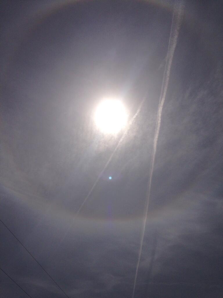
THIS AFTERNOON: A very comfortable afternoon; one of the warmest places in the state is Montgomery; they have reached 75 degrees; Birmingham reports 71 at 3:00p CT. High cirrus clouds have advanced into the state, but the low levels remain dry, and there is no rain on radar. The high clouds, which are ice crystals, have produced nice sky optics today; many have noticed a 22 degree halo around the sun…
WEEKEND CHANGES AHEAD: Tomorrow still looks relatively dry. We can’t rule out a shower, especially over the Tennessee Valley of far North Alabama, but a pretty decent part of the day should be rain-free. The sky will be generally cloudy, although we could see some filtered sunshine, and the high will be in the low to mid 70s.
The high resolution NAM model suggests the primary window for the widespread rain will come from about 12:00 midnight tomorrow night through 12:00 noon Sunday. Rain amounts of 1/2 inch are likely; no severe weather threat, and probably very little thunder.
Sunday will be considerably cooler with a high in the 50s. The sky should clear late Sunday afternoon or Sunday night as drier air works into the state, and Sunday night will be pretty chilly. The 12Z GFS is printing a low of 34 degrees for Birmingham at daybreak Monday, meaning some of the colder pockets around here could see a light freeze.
NEXT WEEK: Monday will be cool and dry with a mix of sun and clouds and a high around 60 degrees. A rapidly deepening low off the Atlantic coast Tuesday will pull down colder air; Tuesday will be breezy and colder with a partly sunny sky; not sure we get out of the 50s, and some communities near the Tennessee border could hold in the 40s all day. The last few global model runs have kept the rain shield with the Atlantic low east of Alabama.
A late season freeze is likely early Wednesday morning… we project a low between 25 and 29 degrees for most of North/Central Alabama. Growers need to be aware of this potential. We begin to warm up Thursday with a high back in the 60s, and some rain is possible by Friday or Saturday (March 28/29).
See the Weather Xtreme video for the maps, graphics, and more details.
AT THE BEACH: Tomorrow will be dry, but mostly cloudy on the Gulf Coast from Panama City west to Gulf Shores. Showers and thunderstorms are likely Sunday, with a few lingering showers possible into Monday. Then, the weather should be dry Tuesday through Thursday of next week with mostly sunny days and fair nights.
Highs on the immediate coast will be in the 60s, and nights next week will be pretty chilly with lows down in the 40s by Wednesday and Thursday morning. The sea water temperature at the Dauphin Island Sea Lab this afternoon is 63 degrees.
WEATHER BRAINS: Don’t forget you can listen to our weekly 90 minute netcast anytime on the web, or on iTunes. This is the show all about weather featuring many familiar voices, including our meteorologists here at ABC 33/40.
CONNECT: You can find me on all of the major social networks…
Facebook
Twitter
Google Plus
Instagram
I had a great time today visiting with the kids at Sycamore Elementary in Talladega County, and the third graders at Chelsea Park Elementary in Shelby County. Be looking for them on the Pepsi KIDCAM at 5:00 and 6:00 this evening on ABC 33/40 News! My next Weather Xtreme video will be posted bright and early Monday morning by 7:00 a.m…. Brian Peters will have the video updates here tomorrow and Sunday. Enjoy the weekend!
Category: Alabama's Weather
About the Author (Author Profile)
James Spann is one of the most recognized and trusted television meteorologists in the industry. He holds the AMS CCM designation and television seals from the AMS and NWA. He is a past winner of the Broadcast Meteorologist of the Year from both professional organizations.Subscribe
If you enjoyed this article, subscribe to receive more just like it.


