

Dry Tomorrow; More Rain By Sunday
**No afternoon Weather Xtreme video today**
CLEARING TONIGHT: The lingering rain over Alabama will end very soon, and the sky will clear this evening as the upper trough axis moves to the east of the state.
Tomorrow promises to be a cool, dry day with a good supply of sunshine and a high in the mid 60s. It will be the time to get outdoors, because clouds and rain will come back quickly later in the weekend.
SUNDAY: The sky becomes cloudy tomorrow night, and it now looks like rain will begin Sunday morning. A long duration, soaking rain event is ahead through Monday morning.
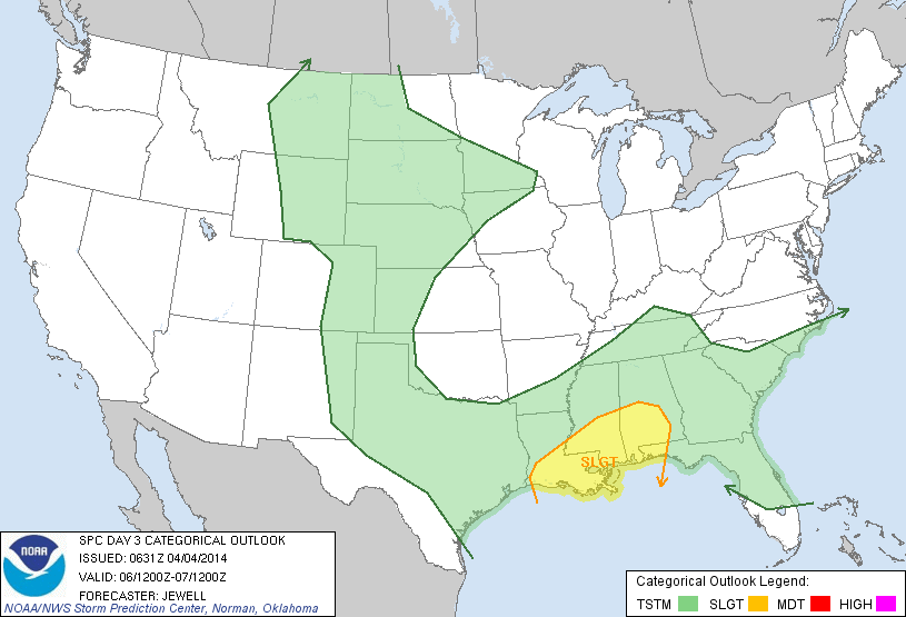
SEVERE WEATHER: SPC has identified a “slight risk” of severe weather over the southern half of Alabama for Sunday night and very early monday morning…
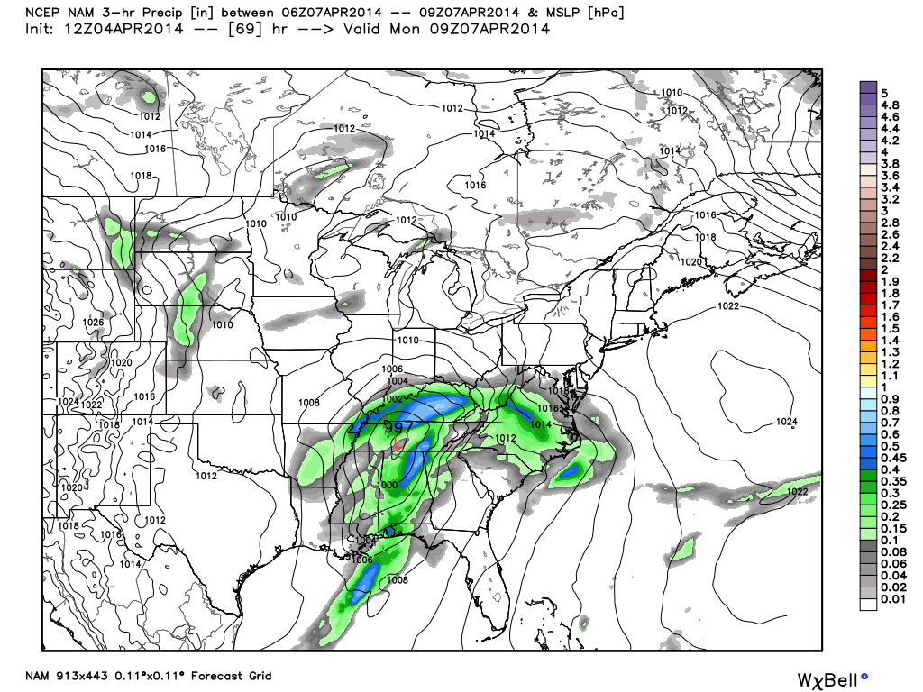
SEVERE STORMS LATE SUNDAY NIGHT? Below is the NAM output, valid at 4am CT Monday…
The placement and intensity of the surface low will be one of the main determining factors for the severe weather threat. Dynamics look strong, but thermodynamics are marginal. Not sure surface based instability can move up into North Alabama, which is the main reason SPC has tagged only the southern counties of the state for a severe weather risk. But, understand sometimes models underestimate instability a few days in advance, and we will need to watch forecast CAPE values closely for North Alabama as well.
For South Alabama, all modes of severe weather will be possible late Sunday night and early Monday morning, including tornadoes. The main window for severe weather will come from about 10:00 p.m. Sunday through 10:00 a.m. Monday.
The rain will be heavy at times statewide Sunday night into Monday morning… rain amounts of 2 to 3 inches are likely, and some flooding issues are possible.
TUESDAY: This will be a mostly cloudy and cool day with some scattered light rain possible as the upper trough swings through.
LATE SEASON FROST: Still concerned we will see some frost early Wednesday or Thursday morning, with lows down in the mid 30s. We will be able to much more specific about this threat to growers over the weekend. Keep an eye on forecast temperatures.
WEATHER BRAINS: Don’t forget you can listen to our weekly 90 minute netcast anytime on the web, or on iTunes. This is the show all about weather featuring many familiar voices, including our meteorologists here at ABC 33/40.
CONNECT: You can find me on all of the major social networks…
Facebook
Twitter
Google Plus
Instagram
I had a great time today visiting with the 3rd graders at Erwin Intermediate School in Center Point… be looking for them on the Pepsi KIDCAM today at 5:00 on ABC 33/40 News! My next Weather Xtreme video will be posted bright and early Monday morning by 7:00 a.m… Brian Peters will have the video updates tomorrow and Sunday. Enjoy the weekend!
Category: Alabama's Weather
About the Author (Author Profile)
James Spann is one of the most recognized and trusted television meteorologists in the industry. He holds the AMS CCM designation and television seals from the AMS and NWA. He is a past winner of the Broadcast Meteorologist of the Year from both professional organizations.Subscribe
If you enjoyed this article, subscribe to receive more just like it.


