

Showers/Storms Increase Tomorrow, Then Cooler
An all new edition of the ABC 33/40 Weather Xtreme video is available in the player on the right sidebar of the blog. You can subscribe to the Weather Xtreme video on iTunes by clicking here.
SUMMER-LIKE WEATHER AGAIN TODAY: Very warm, very humid weather conditions will continue across the great state of Alabama today with a mix of sun and clouds along with a high in the upper 80s. Like recent days, a handful of widely scattered showers and storms will most likely form during the peak of the daytime heating process. Some of them could linger into the night as a cold front approaches from the west.
TOMORROW: Showers and storms become likely statewide. It won’t rain all day, but it could rain at any time during the day, and a few strong thunderstorms are possible, if not likely. SPC keeps the standard “slight risk” of severe weather up for parts of North and West Alabama…
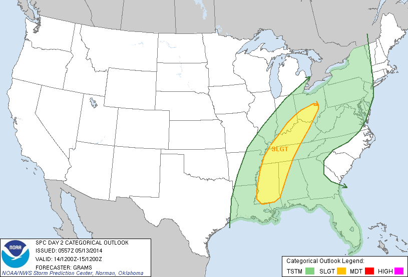
The 06Z NAM shows surface based CAPE values of 1,000-1,200 j/kg, certainly adequate for strong storms, but the shear and wind field values look pretty marginal. If we do have a severe storm around tomorrow afternoon, the main threat would be from hail and strong, gusty winds. The tornado threat is very low.
Rain amounts of 1/2 to 1 inch look likely tomorrow and tomorrow night.
THURSDAY: The weather turns much cooler; we won’t get out of the 60s with a north breeze developing in the wake of the cold front. Rain will end from west to east Thursday morning, and I think the clouds stick around most of the day, although some clearing is possible over West Alabama Thursday afternoon.
FRIDAY AND THE WEEKEND: For North/Central Alabama, the weather looks generally dry and very pleasant. We drop into the 40s early Friday morning, and highs will be in the 70s on these three days with very low humidity levels.
Lobes of energy rotating around the big upper trough over the eastern third of the nation will bring the risk of a little scattered light rain to far North Alabama and Tennessee Friday or Saturday, but I think the air down our way is simply too dry for any significant rain over the weekend.
We stay dry early next week with a warming trend. See the Weather Xtreme video for the maps, graphics, and details.
HANGOUT MUSIC FESTIVAL: This is one of the biggest weekends of the year on the Alabama Gulf Coast at Gulf Shores. Scattered showers and storms are possible today through Thursday, but the weather looks excellent Friday through Sunday with sunny days and fair nights. Highs on the immediate coast will be in the upper 70s, and sea water temperatures are now in the mid to upper 70s.
WEATHER RADIO PROGRAMMING: This week we will be at the Publix on Highway 150 in Hoover Wednesday from 3:30 until 6:30. If you need help with your weather radio, come see us.
WEATHER BRAINS: Don’t forget you can listen to our weekly 90 minute netcast anytime on the web, or on iTunes. This is the show all about weather featuring many familiar voices, including our meteorologists here at ABC 33/40. Scroll down for the show notes on the new episode we recorded last night.
CONNECT: You can find me on all of the major social networks…
Facebook
Twitter
Google Plus
Instagram
I will be doing weather safety program this morning at Alabama Power HQ in downtown Birmingham… look for the next Weather Xtreme video here by 4:00 or so this afternoon. Enjoy the day!
Category: Alabama's Weather
About the Author (Author Profile)
James Spann is one of the most recognized and trusted television meteorologists in the industry. He holds the AMS CCM designation and television seals from the AMS and NWA. He is a past winner of the Broadcast Meteorologist of the Year from both professional organizations.Subscribe
If you enjoyed this article, subscribe to receive more just like it.


