

Life Threatening Situation W Tenn, E Ark, N Miss
Scroll down for Brian’s usual excellent morning weather discussion, but there is serious flooding ongoing to our northwest this morning.
From the NWS Memphis: “This is turning into a life threatening situation. We went with emergency wording on the last FFW”
…FLASH FLOOD EMERGENCY FOR SHELBY…DESOTO AND TUNICA COUNTIES…
THE NATIONAL WEATHER SERVICE IN MEMPHIS HAS EXTENDED THE
* FLASH FLOOD WARNING FOR…
DESOTO COUNTY IN NORTHWEST MISSISSIPPI…
NORTHERN TUNICA COUNTY IN NORTHWEST MISSISSIPPI…
SHELBY COUNTY IN SOUTHWEST TENNESSEE…
* UNTIL 1030 AM CDT
THIS IS A FLASH FLOOD EMERGENCY FOR SHELBY…DESOTO AND TUNICA
COUNTIES.
* AT 709 AM CDT…DOPPLER RADAR ESTIMATES 4 TO 6 INCHES OF RAINFALL
HAS OCCURRED OVER THE PAST 6 HOURS. SHOWERS AND THUNDERSTORMS WILL
PRODUCE AN ADDITIONAL 2 TO 3 INCHES OF RAIN OVER THE NEXT 2 HOURS.
* LOCATIONS IN THE WARNING INCLUDE BUT ARE NOT LIMITED TO BARTLETT…
GERMANTOWN…MILLINGTON…HERNANDO…HORN LAKE…OLIVE BRANCH…
SOUTHAVEN…CORDOVA…MEEMAN SHELBY FOREST STATE PARK AND T O
FULLER STATE PARK.
THIS WARNING ALSO INCLUDES AREAS NEAR CORONEE LAKE…HORN LAKE…
HORSESHOE LAKE…LAKE MCKELLAR AND ROBCO LAKE.
PRECAUTIONARY/PREPAREDNESS ACTIONS…
.FLOOD WATERS ARE MOVING DOWN THE NONCONNAH CREEK AND THE WOLF
RIVER. THE FLOOD CREST IS EXPECTED TO REACH 32.0 FEET BY 9 AM ON THE
NONCONNAH…AND 21.5 FEET ON THE WOLF RIVER BY NOON.
.MOST FLOOD DEATHS OCCUR IN AUTOMOBILES. NEVER DRIVE YOUR VEHICLE
INTO AREAS WHERE THE WATER COVERS THE ROADWAY. FLOOD WATERS ARE
USUALLY DEEPER THAN THEY APPEAR. JUST ONE FOOT OF FLOWING WATER IS
POWERFUL ENOUGH TO SWEEP VEHICLES OFF THE ROAD. WHEN ENCOUNTERING
FLOODED ROADS MAKE THE SMART CHOICE…TURN AROUND…DONT DROWN.
.DO NOT UNDERESTIMATE THE POWER OF FLOOD WATERS. ONLY A FEW INCHES OF
RAPIDLY FLOWING WATER CAN QUICKLY CARRY AWAY YOUR VEHICLE.
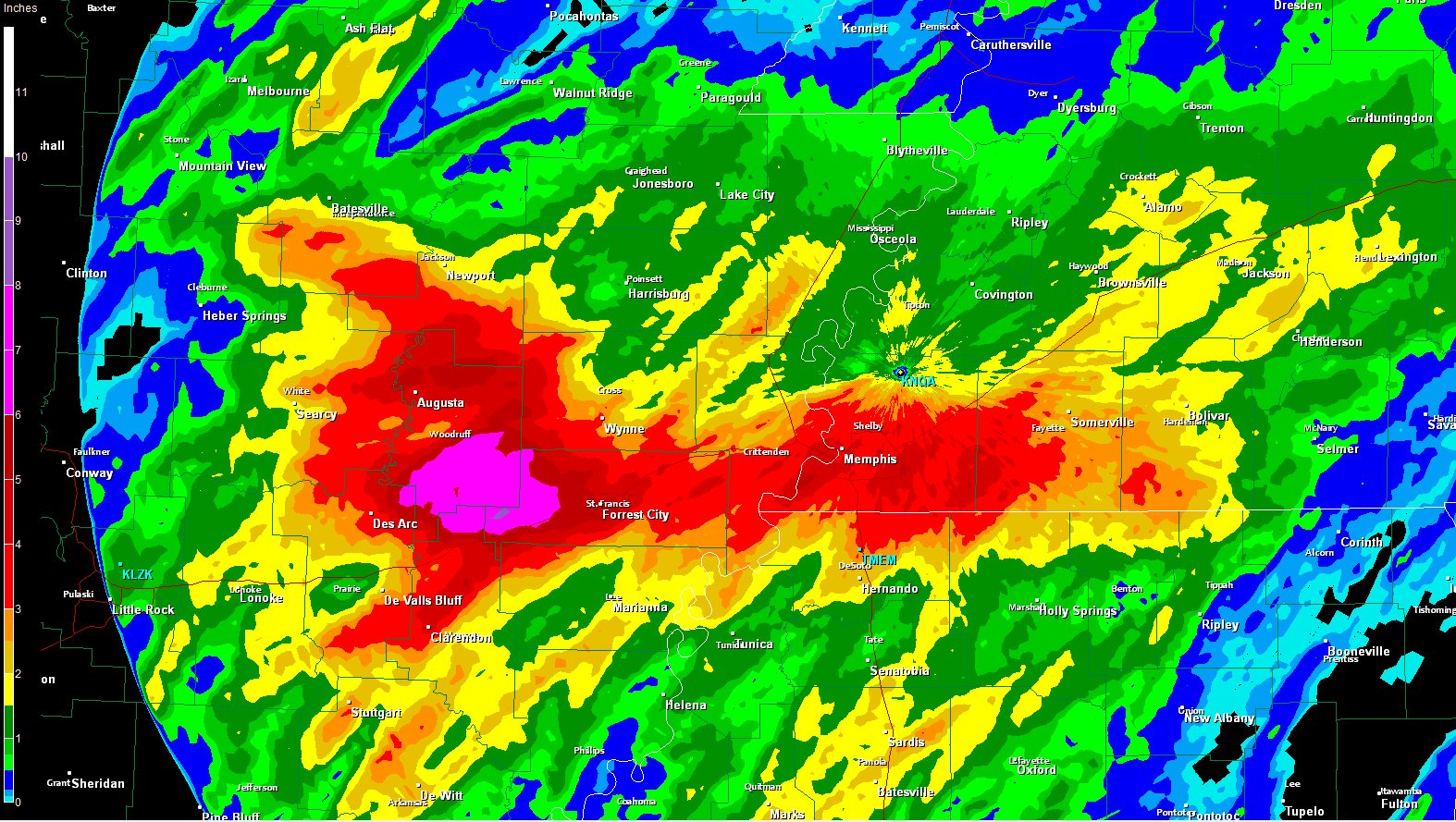
The above graphic shows the radar estimated rainfall amounts overnight and early this morning.
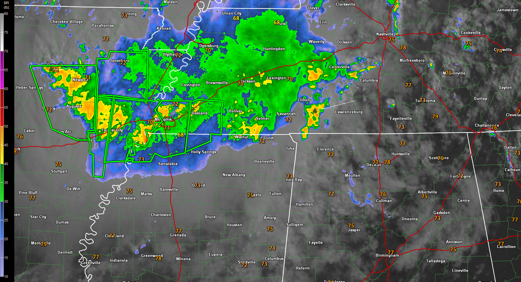
THE SITUATION
They are referring to heavy rain and flash flooding event that is ongoing this morning in eastern Arkansas and western Tennessee.
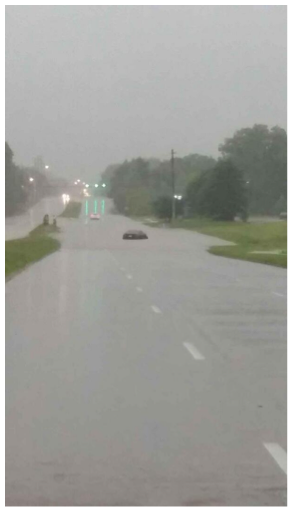
The image is on Winchester in Germantown.
Heavy rain began during the early morning hours in this area as a moist flow (2.1 inch precipitable water values) across an old stalled outflow boundary and an upper level disturbance has led to prodigious rainfall amounts from showers and storms that have been lined up like trains along a track and moving over the same areas for hours.
3-6 inches of rain has fallen across eastern Arkansas from Newport to Des Arc and Clarendon, with a band of 3-5 inches rains extending through the Memphis area.
And more heavy rain is pointed at the Memphis area.
The first warnings came just before 4 a.m. and now flash flood warnings cover an unbroken area from near Batesville AR to Holly Springs MS.
REPORTS
4:55…Quince and White Station area of East Memphis: “prob 4 to 6 inches of water covering the whole street. Flowing very rapidly. Never seen like this here” – A stalled car was reported with the river trapped in that area.
6:00…”Park and Ridgeway, Poplar eastbound before Kirby and Macon at Houston Levee at the Kroger entrance flooded. Multiple cars stranded in high water”
7:24…Here’s info from a tweet by the Memphis FD: ” Winchester/Tchulahoma. Multiple vehicles submerged in water w parties trapped”
7:42…4.02″ in 24 hours in CoCoRaHS gauge at 7:35am 3 miles N of Bartlett TN.
So needless to say, travel in parts of eastern Arkansas and western Tennessee is a problem this morning.
FOR US IN ALABAMA
This activity will spread eastward into Northwest Alabama later this morning as the upper level disturbance lifts northeastward. The heavy rains will continue and flooding will be possible across the rest of northern Mississippi into Northwest Alabama as the moist flow continue and the storms propagate southeastward.
So expect another round of rain and storms later today across North and Northeast Alabama for areas mainly along and north of US-278. Rain chances are high in places like Florence, Huntsville, Arab and Fort Payne.
South of there, showers and storms will be fewer in number.
SIGNIFICANT SEVERE WEATHER AGAIN TODAY IN THE NORTHERN PLAINS
Explosive thunderstorms this afternoon are expected to bring very large hail to the northern Plains again. A moderate risk has been posted for parts of Nebraska, Kansas, Missouri and Iowa. Places like Des Moines, Cedar Rapids, Ames and Iowa City are under the gun for very large hail and the threat of a few tornadoes.
Category: Headlines, Severe Weather
About the Author (Author Profile)
Bill Murray is the President of The Weather Factory. He is the site's official weather historian and a weekend forecaster. He also anchors the site's severe weather coverage. Bill Murray is the proud holder of National Weather Association Digital Seal #0001 @wxhistorianSubscribe
If you enjoyed this article, subscribe to receive more just like it.


