

Storms Starting to Form over Alabama, More to the Northwest
The upper level disturbance that was the trigger behind the tremendous flooding rains in eastern Arkansas, western Tennessee and northern Mississippi is tracking up I-40 between Memphis and Nashville early this afternoon. The precipitation has diminished, because the low level jet that was pouring high moisture content air into a boundary the disturbance had created has weakened.
But that disturbance is still there and it is producing showers and storms on its southeastern and southern flank. Those showers and storms are lined up from Corinth to New Albany to Batesville and Clarksdale across northern Mississippi.
Across North Central Alabama, an unstable air mass is awaiting the wave of forcing along the front edge of the disturbance’s flank. Instability values are running 2,500-3,500 joules/kg, which is high of course. There is little convective inhibition, so showers and storms are bound to form. The convective temperature on the 12z sounding from BMX was 84F, and with temperatures above that all across the area now, showers are forming.
There is a very healthy cumulus field in place across the area as well, as look to the sky indication of the unstable nature of the airmass. Take a gander at this visible satellite/radar depiction with surface temperatures.
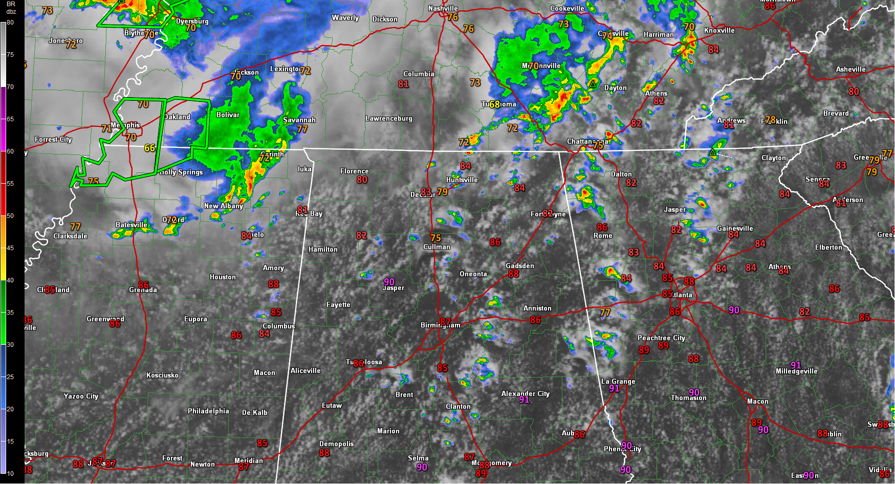
You can see the swirl of the disturbance northeast of Memphis.
You can see fairly numerous showers starting to form over the northern two thirds of Alabama.
Showers will grown into storms across Alabama this afternoon. Rain chances look to be higher than we thought earlier. Storms over northern Mississippi should start to intensify as they push into the more unstable air across Alabama. They will mainly stay near and north of US-278 from Hamilton to Cullman to Gasden, but areas from Fayette to Birmingham to Anniston may get brushed by these storms.
Elsewhere, scattered storms will continue to develop through the afternoon. All of the storms will produce very heavy rain, frequent lightning and gusty winds. Can’t rule out a few severe thunderstorms, with some damaging winds being the threat. We will be watching.
Category: Alabama's Weather, Severe Weather
About the Author (Author Profile)
Bill Murray is the President of The Weather Factory. He is the site's official weather historian and a weekend forecaster. He also anchors the site's severe weather coverage. Bill Murray is the proud holder of National Weather Association Digital Seal #0001 @wxhistorianSubscribe
If you enjoyed this article, subscribe to receive more just like it.


