

Blanket of Moist Air Hangs Around
An all new edition of the ABC 33/40 Weather Xtreme video is available in the player on the right sidebar of the blog. You can subscribe to the Weather Xtreme video on iTunes by clicking here.
ON THE MAPS: An upper low is over South Alabama this morning, and drifting westward. The position of this feature should bring an increase in the number of showers and thunderstorms to the northern half of the state this afternoon and early tonight. It won’t rain everywhere, but any one spot stands about a 50/50 chance of getting wet. Like recent days, a few heavy downpours are possible. Otherwise, the sky will be occasionally cloudy with a high in the mid to upper 80s.
Interesting to note that Birmingham has gone seven consecutive days with a high below 90 degrees.
TOMORROW AND THURSDAY: The upper low will continue to drift west and dissipate, so we expect rather routine summer weather tomorrow. Partly sunny and the risk of scattered, mostly afternoon and evening showers and thunderstorms. The high tomorrow will be in the 87 to 90 degree range.
Then, on Thursday, an approaching surface front from the north should bring an increase in the number of showers and thunderstorms during the afternoon and nighttime hours. A few strong storms are possible, but organized severe weather is not likely.
FRIDAY/SATURDAY: The GFS continues to suggest that drier air will cover the northern half of Alabama on these two days, meaning most places will be rain-free, and humidity levels/dewpoints will be a tad lower. The afternoon high should be around 90 on both days.
SUNDAY AND EARLY NEXT WEEK: Moist air returns Sunday with a chance of scattered showers and thunderstorms, and another “cold front” will push in here late Monday, so the day Monday could be relatively wet with a good chance of showers and storms.
A high amplitude upper air pattern sets up next week with a deep, long wave upper trough over the eastern U.S., and this should set up another refreshing airmass for summer by Tuesday and Wednesday, with lower humidity levels and cooler nights. See the Weather Xtreme video for the maps, graphics, and details.
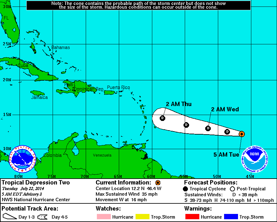
TROPICAL DEPRESSION TWO: TD 2 out in the Atlantic between the Lesser Antilles and the coast of Africa will struggle today due to dry air surrounding the system, and harsh winds aloft. NHC expects the system to weaken to a remnant low before it reaches the islands, and it is not expected to reach tropical storm strength.
Elsewhere, the Atlantic basin is quiet.
GULF COAST WEATHER: About 2 to 4 hours of sunshine today from Panama City to Gulf Shores with scattered showers and storms. Then, for the rest of the week and the weekend, brighter weather with 6 to 8 hours of sun each day with showers and storms being more widely scattered. Highs will hold in the mid to upper 80s along the immediate coast, and the sea water temperature this morning at the Dauphin Island Sea Lab is 84 degrees.
WEATHER BRAINS: Don’t forget you can listen to our weekly 90 minute netcast anytime on the web, or on iTunes. This is the show all about weather featuring many familiar voices, including our meteorologists here at ABC 33/40. Scroll down for the show notes on the new episode we recorded last night with Gary England of Oklahoma City.
CONNECT: You can find me on all of the major social networks…
Facebook
Twitter
Google Plus
Instagram
I will be speaking today at St. Martin’s in the Pines in Birmingham… look for the next Weather Xtreme video here by 4:00 this afternoon. Enjoy the day!
Category: Alabama's Weather
About the Author (Author Profile)
James Spann is one of the most recognized and trusted television meteorologists in the industry. He holds the AMS CCM designation and television seals from the AMS and NWA. He is a past winner of the Broadcast Meteorologist of the Year from both professional organizations.Subscribe
If you enjoyed this article, subscribe to receive more just like it.


