

Rain By Late Tomorrow Afternoon
An all new edition of the ABC 33/40 Weather Xtreme video is available in the player on the right sidebar of the blog. You can subscribe to the Weather Xtreme video on iTunes by clicking here.
RADAR CHECK: The sky is generally cloudy across the great state of Alabama this afternoon, and there is very little action on radar… just a few sprinkles over the eastern counties. Temperatures are generally in the low 50s.
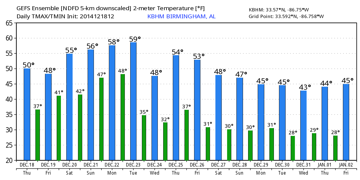
Clouds will linger tonight and tomorrow, and with short wave energy approaching from the west, rain will advance into Alabama from the southwest during the afternoon. The rain will be most widespread tomorrow night; the latest model guidance suggests the higher rain totals will come over South Alabama, where one inch is likely. Up our way, places like Birmingham, Tuscaloosa, Anniston, and Gadsden can expect around 1/2 inch of rain. The prime window for the wet weather will come from about 3:00 p.m. tomorrow through 9:00 a.m. Saturday.
The air will be cool and stable, and there is no risk of severe weather, and we probably won’t have much thunder. We expect a high in the low 50s tomorrow, and mid to upper 50s Saturday.
Sunday looks like a dry day with a comfortable afternoon; the GFS is printing a high of 63 degrees with a little sun through the clouds. A wave in the Gulf will bring the potential for a little light rain to East Alabama late Sunday night and Monday morning; best chance of rain will be along and east of U.S. 431.
CHRISTMAS WEEK: Monday and Tuesday will feature very pleasant afternoons with highs up in the low to mid 60s. But, a cold front will move into Alabama with rain and thunderstorms likely late Tuesday into Tuesday night. A surface low over Tennessee Tuesday evening will deepen rapidly as it moves northeast, and with good upper support we could very well see a few strong thunderstorms around here, but at this point the chance of organized severe weather looks low with very limited instability values.
Wednesday (Christmas Eve) will be colder; clouds linger much of the day with cool north breeze and a high in the upper 40s. A little wrap around moisture could bring a few sprinkles or flurries to far North Alabama Wednesday morning, but for now it looks very insignificant (sorry, snow fans).
Christmas Day on Thursday looks very nice with a good supply of sunshine. We start the day near the freezing mark, down in the low 30s, but rise into the mid 50s by afternoon. Take some time to watch the Weather Xtreme video for maps, graphics, and more details.
WEATHER BRAINS: Don’t forget you can listen to our weekly 90 minute netcast anytime on the web, or on iTunes. This is the show all about weather featuring many familiar voices, including our meteorologists here at ABC 33/40.
CONNECT: You can find me on all of the major social networks…
Facebook
Twitter
Google Plus
Instagram
Had a great time today visiting with the third graders at Cherokee Bend Elementary School in Mountain Brook… be looking for them on the Pepsi KIDCAM today at 5:00 on ABC 33/40 News! The next Weather Xtreme video will be posted here by 7:00 a.m. tomorrow…
Category: Alabama's Weather
About the Author (Author Profile)
James Spann is one of the most recognized and trusted television meteorologists in the industry. He holds the AMS CCM designation and television seals from the AMS and NWA. He is a past winner of the Broadcast Meteorologist of the Year from both professional organizations.Subscribe
If you enjoyed this article, subscribe to receive more just like it.


