

Wet and Colder Weather Returns Late This Week
An all new edition of the ABC 33/40 Weather Xtreme video is available in the player on the right sidebar of the blog. You can subscribe to the Weather Xtreme video on iTunes by clicking here.
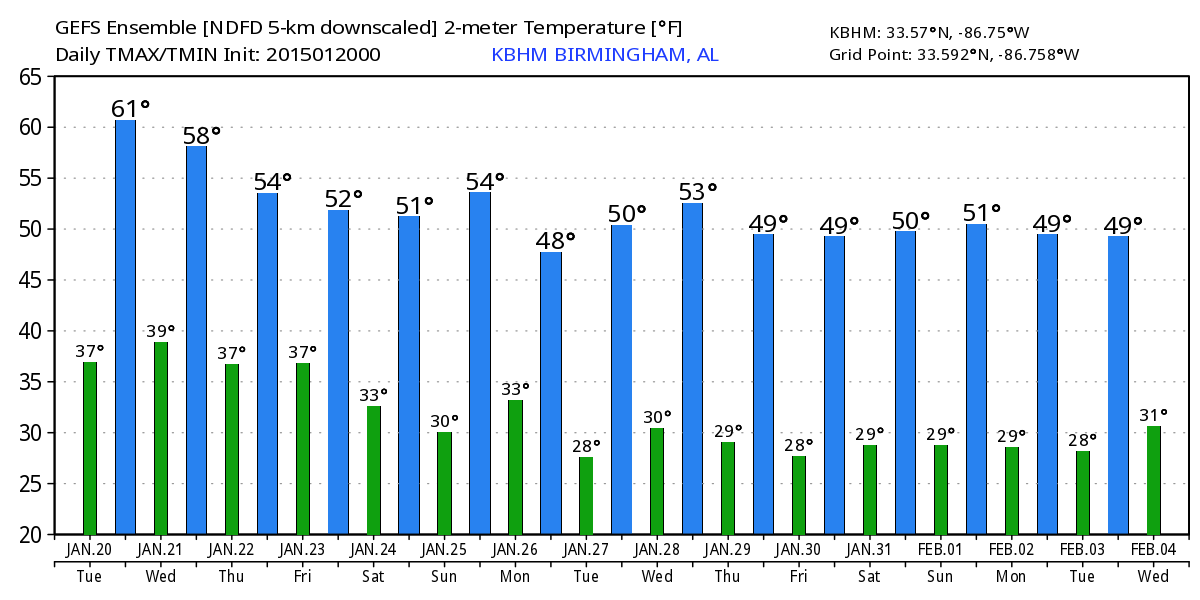
STILL MILD TODAY: Looks like most North/Central Alabama communities will enjoy a high in the 62-65 degree range today, about ten degrees above average for January 20, but still well below the record high of 78 degrees set way back in 1928. We expect a good supply of sunshine through scattered clouds, much like yesterday.
Not much change tomorrow; the high will be close to 60 degrees with a mix of sun and clouds.
RAIN RETURNS: A strong wave in the southern branch of the jet stream will spin up a surface low in the northern Gulf of Mexico later this week; clouds increase across Alabama Thursday, and rain will begin at some point Thursday night. Models have trended stronger, and further north with the precipitation shield in recent runs. Friday looks like a cool and wet day, with occasional rain along with temperatures in the 40s. The heaviest rain will be over the southern quarter of the state, where one inch is possible… amounts up this way (North/Central Alabama) will be in the 1/4 to 1/2 inch range.
THE ALABAMA WEEKEND: We will also have to adjust the forecast to keep some risk of light rain going through Friday night and Saturday morning as the surface low moves northeast… the latest GFS hints the rain will be over by 9:00 a.m. to 12:00 noon Saturday, and we might see some clearing late in the day. Saturday will remain cool with a high in the mid to upper 40s.
Sunday for now looks cool and dry, with a partly sunny sky and a high in the low 50s.
NEXT WEEK: An Alberta Clipper will bring clouds and some risk of light rain to the state early next week on Monday. These features don’t have much moisture to work with, so precipitation amounts should be light. Might even be some risk of a snow flake or two around the Tennessee Valley Monday night, but it sure doesn’t look like a big deal. Then, cool and dry weather is the story for mid-week.
No sign of any seriously cold air for Alabama through the end of the month, with the Arctic Oscillation and the North Atlantic Oscillation remaining generally positive. See the Weather Xtreme video for maps, graphics, and more long range ideas.
WEATHER BRAINS: Don’t forget you can listen to our weekly 90 minute netcast anytime on the web, or on iTunes. This is the show all about weather featuring many familiar voices, including our meteorologists here at ABC 33/40. Scroll down for the show notes on the new episode we recorded last night.
CONNECT: You can find me on all of the major social networks…
Facebook
Twitter
Google Plus
Instagram
I have a weather program today at Weaver Elementary School in Calhoun County… be looking for the next Weather Xtreme video here by 4:00 or so this afternoon. Enjoy the day!
Category: Alabama's Weather
About the Author (Author Profile)
James Spann is one of the most recognized and trusted television meteorologists in the industry. He holds the AMS CCM designation and television seals from the AMS and NWA. He is a past winner of the Broadcast Meteorologist of the Year from both professional organizations.Subscribe
If you enjoyed this article, subscribe to receive more just like it.


