

Clear Tonight; Storms Late Tomorrow
An all new edition of the ABC 33/40 Weather Xtreme video is available in the player on the right sidebar of the blog. You can subscribe to the Weather Xtreme video on iTunes by clicking here.
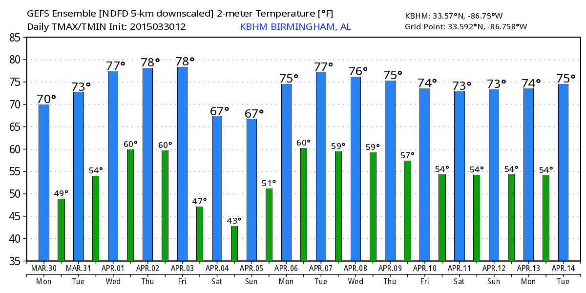
SUNNY SPRING AFTERNOON: As expected, the sky has become sunny this afternoon following the round of early morning thunderstorms. Temperatures are mostly in the 70-75 degree range, about where we should be for the end of March in Alabama.
The sky will stay clear tonight; most spots will will drop into the 48-52 degree range early tomorrow.
STORMS RETURN: SPC has much of Alabama in a “marginal” severe weather risk tomorrow afternoon and evening; moisture will return during the day, and scattered showers and storms should develop during the afternoon. Model guidance is suggesting some decent surface based instability, with CAPE values approaching 2,000 j/kg in spots by late afternoon. Some of the storms that develop late tomorrow could produce small hail and gusty winds… they will settle down later tomorrow night. The high tomorrow will be in the mid 70s.
WEDNESDAY/THURSDAY: While we certainly could see a few showers or storms on these two days, they should be widely spaced, and we should see a decent amount of sunshine through scattered clouds. Afternoon highs will rise to near 80 degrees.
FRIDAY: Looks like a decent part of the day Friday will be dry, but showers could develop by mid to late afternoon. An organized band of showers and storms will likely pass through Friday night ahead of a cold front… at this point the severe weather risk looks low with only a very limited amount of surface based instability.
EASTER WEEKEND: The sky becomes mostly sunny Saturday, but the day will be cooler with a high between 60 and 65 degrees. Sunday morning will be chilly; most places will see a low in the 40-45 degree range, but colder valleys and protected areas across North and Central Alabama could visit the mid to upper 30s. Then, during the day Sunday, it will be sunny and pleasant with a high in the mid to upper 60s.
NEXT WEEK: Moisture returns Monday (April 6), and we will bring back the risk of showers and thunderstorms. The weather looks somewhat unsettled through mid-week… see the Weather Xtreme video for maps, graphics, and more details.
GULF COAST WEATHER: About 7 to 9 hours of sunshine each day through Friday on the Gulf Coast with only widely scattered showers; showers and storms are more likely late Friday night into Saturday morning, then the rest of the Easter weekend will be dry from Panama City over to Gulf Shores. Highs will be mostly in the 70s, with lows in the 60s. The sea water temperature this afternoon at the Dauphin Island Sea Lab is a cool 65 degrees.
WEATHER BRAINS: Don’t forget you can listen to our weekly 90 minute netcast anytime on the web, or on iTunes. This is the show all about weather featuring many familiar voices, including our meteorologists here at ABC 33/40. We will produce this week’s show tonight at 8:30 CT… you can watch it on “James Spann 24/7” on cable systems around the state, or on the web here.
CONNECT: You can find me on all of the major social networks…
Facebook
Twitter
Google Plus
Instagram
Look for the next Weather Xtreme video here by 7:00 a.m. tomorrow….
Category: Alabama's Weather
About the Author (Author Profile)
James Spann is one of the most recognized and trusted television meteorologists in the industry. He holds the AMS CCM designation and television seals from the AMS and NWA. He is a past winner of the Broadcast Meteorologist of the Year from both professional organizations.Subscribe
If you enjoyed this article, subscribe to receive more just like it.


