

Some Weather Changes Ahead
LONG DRY SPELL ABOUT TO END: We have gone eleven consecutive days with no rain across North/Central Alabama; the last measurable rain was back on April 29 when 0.14″ was measured. The upper pattern across the nation has been blocked, with multiple days of severe weather across the southern part of the Great Plains and dry weather here under an upper ridge.
We should note Birmingham officially reached 90 degrees yesterday for the first time since September 21 of last year.
TODAY: We will project a high in the 87 to 90 degree range again today with a partly sunny sky; we will mention the chance of a few isolated afternoon showers or thunderstorms, mainly in the western side of the state.
TONIGHT: With the approach of a surface front, an organized band of showers and storms should move into the northwest part of the state after 10:00 p.m…. and the storms could be strong. SPC has the standard “slight” risk of severe weather outlooked down to I-59 (Tuscaloosa, Birmingham, Gadsden) late tonight and early tomorrow morning.
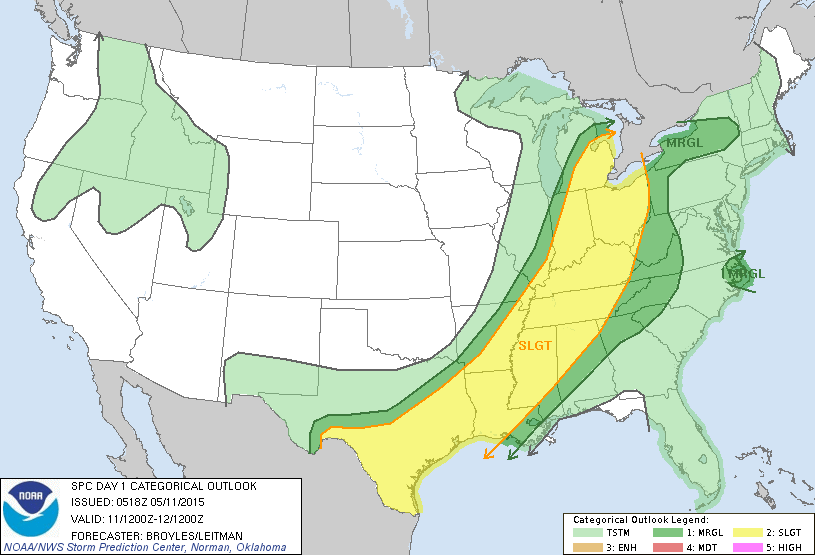
However, severe weather parameters are less than impressive. The primary surface low will be far to the north, over the Great Lakes, along with the better upper dynamics. Instability values aren’t very high (generally under 1,000 j/kg), and shear is low as well.
NWS Birmingham is not going to mention severe weather in their products, and I seriously doubt if we have any serious severe weather issues. However, this system has certainly as had a history of severe weather problems, and when it comes to thunderstorms, expect the unexpected. We will watch radar trends overnight just in case.
TOMORROW: Showers should end pretty early in the day, and the sky becomes partly sunny by afternoon as drier air works into the state. The high tomorrow will be in the low to mid 80s with dewpoints and humidity levels dropping through the day.
WEDNESDAY: This should be the nicest day of the week, with ample sunshine, low humidity, and a high around 80 degrees. Might be the the last time we see dewpoints in the 40s until late September.
THURSDAY/FRIDAY: Moisture comes back Thursday, and we will introduce the chance of a few scattered afternoon showers or thunderstorms. Then, a pool of deep moisture will arrive Friday, when the sky will be generally cloudy along with a good chance of showers and storms. It won’t rain all day Friday, but the rain could come at any time. We will have a hard time getting out of the 70s Friday due to clouds and showers.
THE WEEKEND: A moist, unstable airmass will linger, so there will be a continued risk of showers and storms both Saturday and Sunday. Not a wash-out by any means, but just understand you will have to dodge showers, and maybe a thunderstorm, from time to time over the weekend. Highs will be in the low to mid 80s with high humidity values. The sun might peek out at times, but we will have more clouds than sun both days.
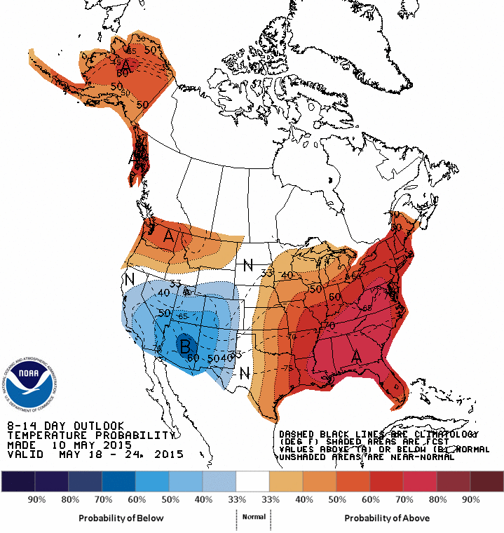
The muggy conditions will linger into next week; see the Weather Xtreme video for maps, graphics, and more details. And, it looks like temperatures will be above average here for the latter part of May as the upper ridge hangs on.
TROPICS: Tropical Storm Ana made landfall over the weekend near Myrtle Beach, SC… it is dissipating today, but still producing breezy and showery weather over the mid-Atlantic coast region.
AT THE BEACH: Expect a sunny sky today from Panama City west to Gulf Shores with a high close to 80 on the immediate coast, with upper 80s inland. Then, for the rest of the week and the weekend, about 6 to 8 hours of sunshine daily with some risk of scattered showers or storms. Not too bad for the Hangout Music Festival at Gulf Shores this weekend. The sea water temperature at the Dauphin Island Sea Lab this morning is 79 degrees.
WEATHER BRAINS: Don’t forget you can listen to our weekly 90 minute netcast anytime on the web, or on iTunes. This is the show all about weather featuring many familiar voices, including our meteorologists here at ABC 33/40. We will produce this week’s show tonight at 8:30 CT… you can watch it on “James Spann 24/7” on cable systems around the state, or on the web here.
CONNECT: You can find me on all of the major social networks…
Facebook
Twitter
Google Plus
Instagram
Look for the next Weather Xtreme video here by 4:00 this afternoon… enjoy the day…
Category: Alabama's Weather
About the Author (Author Profile)
James Spann is one of the most recognized and trusted television meteorologists in the industry. He holds the AMS CCM designation and television seals from the AMS and NWA. He is a past winner of the Broadcast Meteorologist of the Year from both professional organizations.Subscribe
If you enjoyed this article, subscribe to receive more just like it.


