

Heat Staying Up
Our weather pattern for Central Alabama remains stuck on the large surface and upper ridge that remain in place over the Southeast US giving us some of the hottest days so far for 2015. Heat advisories have also been posted for parts of Southeast Alabama as well as parts of South Georgia and North Florida. Look for highs to again be in the middle 90s with showers remaining scarce.
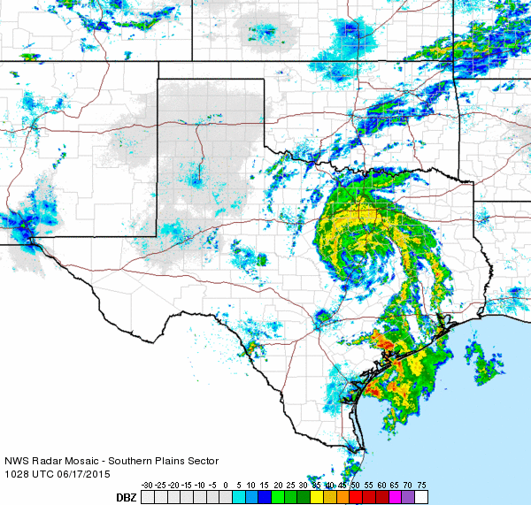
The remnants of Tropical Storm Bill are moving generally northward across North Central Texas this morning. The remnants of Bill will continue to produce heavy rainfall for parts of the Central Plains and the Ohio River Valley over the next several days with much of that area covered by flash flood watches. While the upper reflection of Bill will move by North Alabama on Saturday, we are not likely to see much of an impact on our weather with perhaps a few more clouds taking a couple of degrees off the highs and slightly better rain chances especially north of Interstate 20.
With Bill moving further inland, high surf has diminished along the beaches of Alabama and Northwest Florida, reducing the rip current threat too. Fairly typical June weather will prevail this week, with temps at the beach in the mid to upper 80s and lows in the mid-70s, and expect mid-90s just inland. Showers and storms will form right along the immediate coast during the late morning and move inland with the sea breeze. Rain chances along the immediate coast will very low, less than 20 percent. Water temperature yesterday afternoon at the Dauphin Island Sea Lab was 84 degrees.
The upper level feature that once was Bill will move out of the picture Sunday as it is replaced by a strong upper ridge building into the Lower Mississippi Valley from the southwest. This should bring the temperatures back up into the middle and upper 90s for start of next week with only small chances for an isolated shower or two.
Conditions across the Tropical Atlantic are quiet after Bills departure from the Northwest Gulf. Carlos continues to dissipate on the west coast of Mexico.
Looking out into Week 2 or voodoo country, the GFS is not as bullish this morning on the development of the trough over the eastern US, so does not look as hopeful for a big break in the heat.
I expect to post the next Weather Xtreme Video here on Thursday morning. Stay cool and Godspeed.
-Brian-
Category: Alabama's Weather
About the Author (Author Profile)
Brian Peters is one of the television meteorologists at ABC3340 in Birmingham and a retired NWS Warning Coordination Meteorologist. He handles the weekend Weather Xtreme Videos and forecast discussion and is the Webmaster for the popular WeatherBrains podcast.Subscribe
If you enjoyed this article, subscribe to receive more just like it.


