

Update on the Storms
Four areas of storms to worry about tonight:
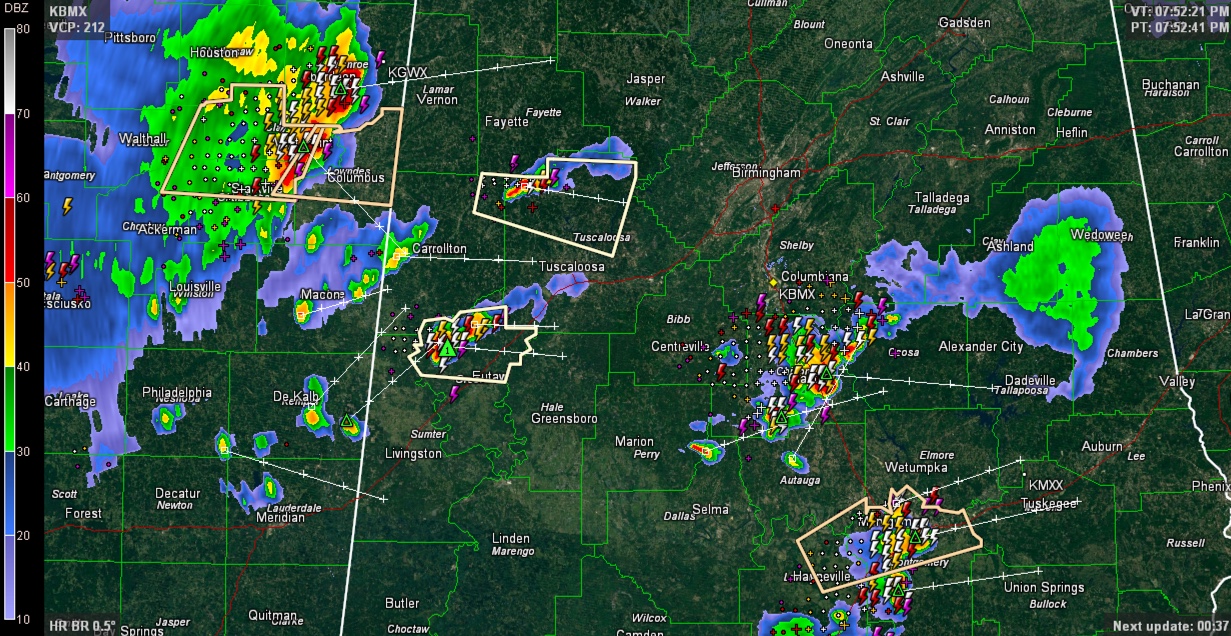
1. Chilton County storms are quite strong, but not severe. Lots of lightning and heavy rain as well as gusty winds. They are straddling I-65 around Lomax and Clanton. They will be approaching Lake Mitchell shortly.
2. Montgomery Area: strong storms with lots of lightning in the Montgomery area.
3. West Central Alabama: A couple of isolated strong storms are over northwestern Tuscaloosa County and northwestern Greene County. The Tuscaloosa storm will affect areas well north of the City of Tuscaloosa, the University of Alabama and Northport, mainly affecting rural areas near and around Moores Bridge Samanatha as it moves east southeast. This storm will stay just north of Lake Tuscaloosa. The Greene County storm will cross I-59 around Eutaw and Knoxille before 8:15.
4. Approaching Pickens and Lamar Counties: Strong to severe storms in eastern Mississippi from Amory to Aberdeen to West Point will be reaching West Alabama’s Lamar and northern Pickens Counties starting around 815 p.m. The storms should reach Vernon before 8:30 and Millport before 8:45.
The storms are not severe at this time, but have the potential to become severe thanks do some fairly significant wind shear for summer. All of the storms will be capable of deadly lightning, very heavy rain and strong gusty winds.
The polygons in peach are Significant Weather Alerts from the NWS.
Category: Alabama's Weather
About the Author (Author Profile)
Bill Murray is the President of The Weather Factory. He is the site's official weather historian and a weekend forecaster. He also anchors the site's severe weather coverage. Bill Murray is the proud holder of National Weather Association Digital Seal #0001 @wxhistorianSubscribe
If you enjoyed this article, subscribe to receive more just like it.


