

Severe Thunderstorm Watch in Our Future?
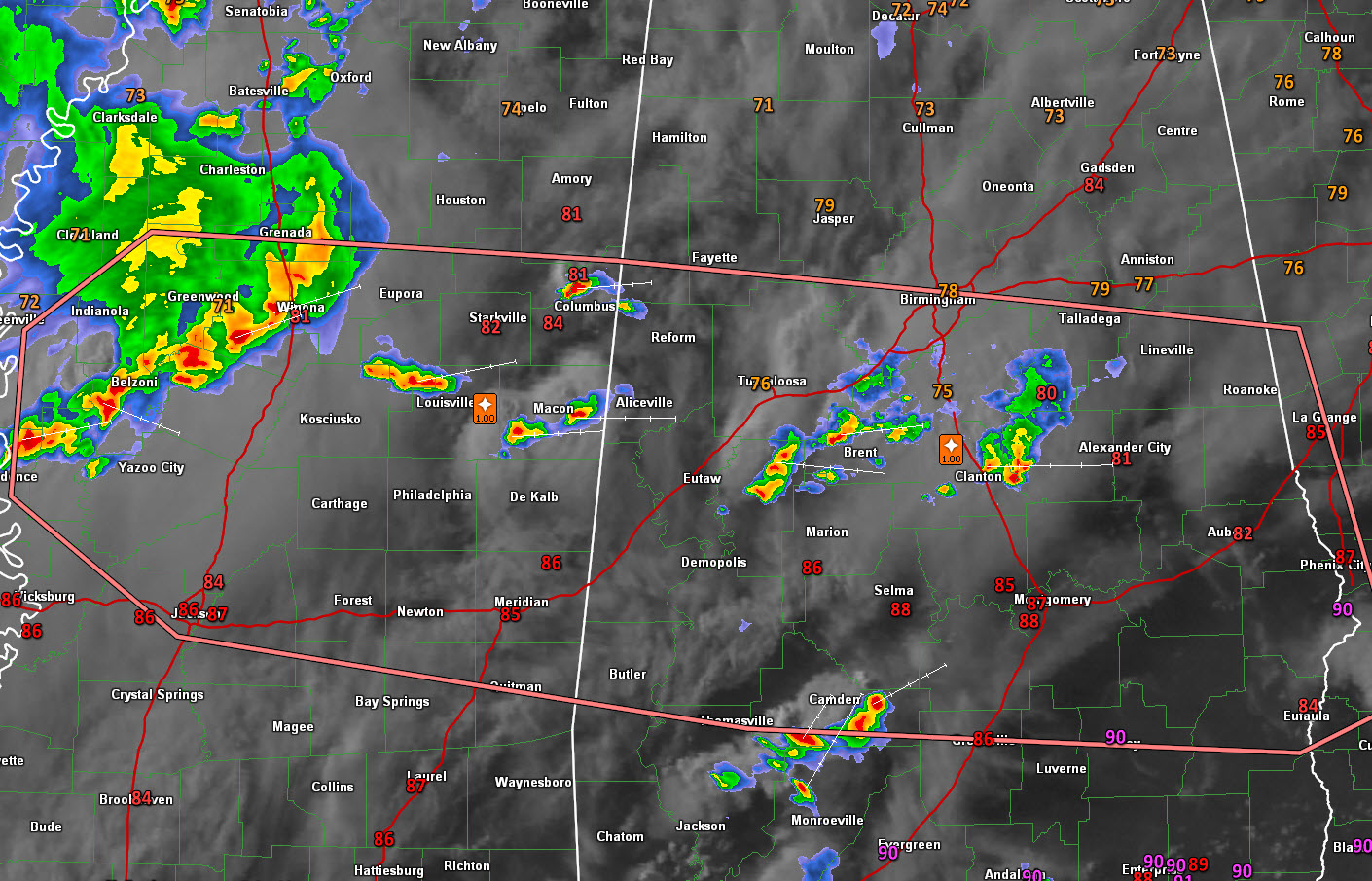
Strong thunderstorms have developed afternoon across Central Alabama. One storm that has moved out of Chilton County and is now crossing Coosa County around Lake Mitchell has produced hail to 1.5 inches in diameter, including numerous reports of large hail back in Bibb County and in the Jemison area. Numerous reports of 1 inch hail were received from around Jemison. Some trees were also reported down in Bibb County.
0.72 inches of rain was reported in Thorsby in 20 mins according to @nightnurse24 (Tracy McDaniel). Justin Gentry reported 0.71 inches in Jemison. Back in Tuscaloosa County, Wallace Williams reported 0.72 inches at Cottondale.
This storm is a little weaker now, but a trailing storm is catching up to the first storm and the two are about to merge over Coosa County west of Rockford.
Other storms are over northern Hale and much of Bibb County at this hour. They will be moving across much of Shelby County over the next couple of hours. These storms are not as strong as the Chilton/Coosa County storms for now.
The storms are tapping an instability-rich airmass to the south of an outflow boundary that settled into North Central Alabama this morning. South of I-20, CAPE values are over 2,000 j/kg. The storms should continue to be strong for the next few hours thanks to decent winds aloft at about 18,000 that are blowing across Central Mississippi and Central Alabama. These winds of up to 50 mph are producing a decent amount of speed shear that is allowing our storms to lean over and not choke on their own updrafts like garden variety summer storms do.
This speed max will be shifting eastward across Alabama this evening. As it does, it will allow storms to continue strong. A complex of thunderstorms back in western Mississippi and additional strong to severe storms over eastern Mississippi will track west to east across the state through the evening and overnight.
A severe thunderstorm watch may be issued for Central Alabama a little later.
Damaging winds and some hail will be the severe threats, along with very heavy rain and intense lightning.
Stay weather aware tonight, especially if you have outdoor holiday plans.
Category: Severe Weather
About the Author (Author Profile)
Bill Murray is the President of The Weather Factory. He is the site's official weather historian and a weekend forecaster. He also anchors the site's severe weather coverage. Bill Murray is the proud holder of National Weather Association Digital Seal #0001 @wxhistorianSubscribe
If you enjoyed this article, subscribe to receive more just like it.


