

Tuesday’s Severe Weather Threat
Here are a few quick notes concerning the severe weather potential in Alabama Tuesday.
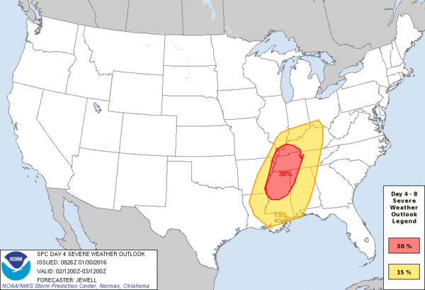
Our friends at the Storm Prediction Center have shifted the higher risk a little westward, but it still includes the northwest corner of Alabama…
The good news is that global models (American and European) have trended farther north with the surface low, and the associated upper support, in recent runs. Below is the GFS (06Z run) valid at 6pm CT Tuesday…
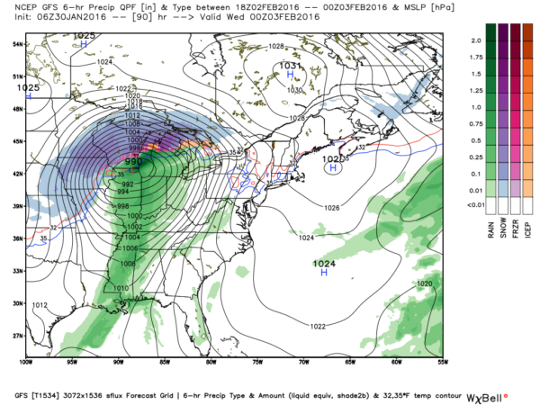
Note how the surface low is near Chicago; earlier runs had it closer to St. Louis.
Based on these trends… here is what I am thinking now…
TIMING: The main window for severe storms across North/Central Alabama will come from 4:00 p.m. Tuesday through 2:00 a.m. Wednesday.
THREATS: The tornado threat for Alabama has lessened somewhat, but is still there. Highest risk of a tornado with this event will be in places like Memphis; in our state higher tornado probabilities will be up around Muscle Shoals, in the northwest corner of the state. Storms will evolve into a long line Tuesday night with potential for damaging straight line winds, and some hail.
RAIN: Amounts of 1/2 to 1 inch are likely, and flooding is not expected.
This system will get into the American upper air network over the next 48 hours, and forecast confidence will continue to grow. Enjoy this fine weekend, and just understand severe storms will be possible in Alabama late Tuesday and Tuesday night. You might want to check your weather radio sometime this weekend, and put in a fresh backup battery. Be sure you know where are you are going if you do get into a tornado warning polygon, and have a readiness kit in that safe place including helmets, airhorns and whistles, and hard sole shoes.
We will keep you updated through the weekend.
Category: Alabama's Weather
About the Author (Author Profile)
James Spann is one of the most recognized and trusted television meteorologists in the industry. He holds the AMS CCM designation and television seals from the AMS and NWA. He is a past winner of the Broadcast Meteorologist of the Year from both professional organizations.Subscribe
If you enjoyed this article, subscribe to receive more just like it.


