

Severe Weather Threat Begins Tomorrow Afternoon
LIKE SPRING: Temperatures have soared into the low 70s across most of Central Alabama this afternoon with intervals of sunshine. We do have showers on radar, but they are scattered, and mostly over far North Alabama, and across the southeast part of the state. A few showers are possible tonight, but they will be widely spaced.
ACTIVE WEATHER AHEAD: A deepening surface low will move across the Great Plains tomorrow, with heavy snow in the cold air just north of the low track. But, needless to say, we are in the warm sector, and temperatures tomorrow will again push toward the low 70s, with dewpoints rising into the mid 60s. The air will become unstable by afternoon, with surface based CAPE values between 500 and 1000 j/kg.
With the approaching upper dynamics, it looks like strong to severe storms will begin to form by late afternoon across North Alabama, and severe weather still looks likely.
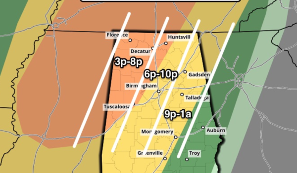
PLACEMENT: The highest severe weather probabilities are in the “enhanced” severe weather outlook region, which is generally along and west of a line from Huntsville to Tuscaloosa. But, understand severe storms are possible into parts of East Alabama as well tomorrow night.
MODES: Storms that fire late tomorrow afternoon and tomorrow evening will be cellular in nature, and those could produce a few tornadoes, especially over Northwest Alabama. Storms are also capable of producing large hail and damaging straight line winds. Activity should evolve into a long line of storms tomorrow night after 9:00 p.m.
TIMING: Storms should begin to form soon after 3:00 p.m. over West Alabama… highest tornado threat will come from 3:00 until 8:00 p.m… after that the risk will be more from damaging straight line winds as the line forms.
RAIN: Rain amounts around one inch are likely, but the line will slow down over East Alabama after midnight tomorrow night, and some spots could see up to 2 inches there, which could mean some risk of flooding.
CALL TO ACTION: As always, be sure you are in a position to hear warnings if they are needed, have a plan of action, and a readiness kit in your safe place. See this post I wrote before Christmas on specific things to do.
WEDNESDAY: Rain will end early in the day, followed by gradual clearing with a high at or just over 60 degrees.
THURSDAY/FRIDAY: These two days will be cool and dry with highs in the 50s; coldest morning will come early Friday, when upper 20s are possible.
THE ALABAMA WEEKEND: Saturday will be mostly sunny and cool with a high in the mid 50s; clouds will slowly increase Sunday, and some light rain could arrive Sunday night. Heaviest rain will come over the southern half of the state Sunday.
NEXT WEEK: Still seeing signals of a shot of pretty cold air down into the eastern half of the U.S. toward the middle of next week; see the Weather Xtreme video for maps, graphics, and more details…
WEATHER BRAINS: Don’t forget you can listen to our weekly 90 minute netcast anytime on the web, or on iTunes. This is the show all about weather featuring many familiar voices, including our meteorologists here at ABC 33/40. We will produce this week’s show tonight at 8:30 CT… you can watch it here.
CONNECT: You can find me on all of the major social networks…
Facebook
Twitter
Google Plus
Instagram
I had a great time today visiting with 1st graders at Vestavia Hills Cahaba Heights Elementary… and Calera Elementary… be looking for them on the Pepsi KIDCAM today at 5:00 and 6:00 on ABC 33/40 News! The next Weather Xtreme video will be posted here by 7:00 a.m. tomorrow…
Category: Alabama's Weather
About the Author (Author Profile)
James Spann is one of the most recognized and trusted television meteorologists in the industry. He holds the AMS CCM designation and television seals from the AMS and NWA. He is a past winner of the Broadcast Meteorologist of the Year from both professional organizations.Subscribe
If you enjoyed this article, subscribe to receive more just like it.


